TopoQuest Logo
Do you find TopoQuest useful?
Help keep TopoQuest running and adding new maps/features by donating!
Bitcoin:  19c7KJd3qBynnjoSw5npx9KScwjBe4ifkT
Litecoin:  LXs6TkuXGGXo1vDsWCkWVdjQX94eUKd6ui
Home View Maps Find Maps Find Places Resources & Links


Waynesburg, Pennsylvania Topographic Map

USGS Map Title: Waynesburg, PA
USGS Map MRC: 39080H2
DRG (GeoTIFF) Download: o39080h2.tif


Neighboring USGS Topographic Map Quads:


  Prosperity, PA  
40080A3
 

  Amity, PA  
40080A2
 

  Ellsworth, PA  
40080A1
 

  Rogersville, PA  
39080H3
 

  Waynesburg, PA  
39080H2
 

  Mather, PA  
39080H1
 

  Holbrook, PA  
39080G3
 

  Oak Forest, PA  
39080G2
 

  Garards Fort, PA  
39080G1


Map MRC Location:

N40°
W81°
N40°
W80°
H8 H7 H6 H5 H4 H3 H2 H1
G8 G7 G6 G5 G4 G3 G2 G1
F8 F7 F6 F5 F4 F3 F2 F1
E8 E7 E6 E5 E4 E3 E2 E1
D8 D7 D6 D5 D4 D3 D2 D1
C8 C7 C6 C5 C4 C3 C2 C1
B8 B7 B6 B5 B4 B3 B2 B1
A8 A7 A6 A5 A4 A3 A2 A1
N39°
W81°
N39°
W80°

Waynesburg, PA USGS 1:24K Topographic Map Preview:
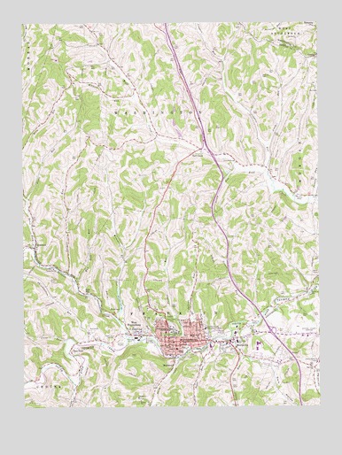
Waynesburg, PA USGS Topographic Map
Click on map above to begin viewing in our Map Viewer.

This topographic map contains these locations and features:
Feature Name Type Latitude Longitude GNIS ID View Map
Alumni Conference BuildingBuildingN39.8997°W80.1883°2115441View Map
Bates ForkStreamN39.9265°W80.2453°1168801View Map
Behl Humanites BuildingBuildingN39.8994°W80.1853°2115442View Map
BlairtownPopulated PlaceN39.8890°W80.1865°1169803View Map
Borough of WaynesburgCivilN39.8983°W80.1856°1215263View Map
Boyd RunStreamN39.9576°W80.1731°1170082View Map
Browns CreekStreamN39.8973°W80.2053°1170386View Map
Burns HallBuildingN39.9014°W80.1878°2115444View Map
Carl D Johnson CommonsLocaleN39.9000°W80.1872°2115445View Map
CastilePopulated PlaceN39.9887°W80.1262°1203230View Map
Clear RunStreamN39.8965°W80.2317°1171968View Map
Coal Lick ChurchChurchN39.8876°W80.1270°1172058View Map
College FieldParkN39.8931°W80.1817°1172204View Map
Craig RunStreamN39.9595°W80.1467°1172600View Map
Craynes RunStreamN39.9515°W80.1459°1198054View Map
Curry Memorial HomeBuildingN39.8892°W80.1259°1172844View Map
Dark HollowValleyN39.8875°W80.1445°1172938View Map
Denny HallBuildingN39.9008°W80.1878°2115446View Map
East ViewPopulated PlaceN39.8937°W80.2298°1173896View Map
East Ward Elementary SchoolSchoolN39.8984°W80.1790°1213836View Map
Eberty LibraryBuildingN39.9000°W80.1853°2115448View Map
Emerald Ball ParkParkN39.8965°W80.1990°1174215View Map
Emergency Medical Services Southwest WaynesburgBuildingN39.8897°W80.1426°2719667View Map
Garners RunStreamN39.9181°W80.2312°1175459View Map
Goodwin HouseBuildingN39.8981°W80.1850°2115450View Map
Green Mount CemeteryCemeteryN39.9019°W80.1873°1176092View Map
Greene County AirportAirportN39.8992°W80.1327°1193767View Map
Greene County Sheriff's OfficeBuildingN39.8961°W80.1866°2780305View Map
Greene PlazaLocaleN39.8976°W80.1465°1211689View Map
Grimes PortalMineN39.9431°W80.1342°1176236View Map
Grimes RunStreamN39.9040°W80.1492°1176237View Map
Jackson RunStreamN39.8940°W80.1753°1177928View Map
Jersey RunStreamN39.9534°W80.1589°1178059View Map
Johnson CemeteryCemeteryN39.9826°W80.1484°1178109View Map
Laurel RunStreamN39.9029°W80.1570°1178999View Map
Marisa FieldhouseBuildingN39.8981°W80.1875°2115452View Map
MorrisvillePopulated PlaceN39.8948°W80.1617°1181588View Map
Morrisville Census Designated PlaceCensusN39.9007°W80.1678°2389508View Map
Mud Lick RunStreamN39.9159°W80.2281°1182007View Map
North Ward SchoolSchoolN39.8995°W80.1862°1214086View Map
Oakmont CemeteryCemeteryN39.9123°W80.1986°1182844View Map
Paul R Stewart MuseumBuildingN39.8994°W80.1875°2115456View Map
Paul R Stewart Science CenterBuildingN39.8981°W80.1867°2115457View Map
Pennsylvania State Police Troop B Waynesburg StationBuildingN39.8962°W80.1464°2777325View Map
Pettit RunStreamN39.9429°W80.2478°1183646View Map
Pollock HallBuildingN39.8992°W80.1850°2115459View Map
Poverty RunStreamN39.9434°W80.1262°1184355View Map
President's Home - Waynesburg CollegeBuildingN39.8992°W80.1889°2115460View Map
Purman RunStreamN39.8931°W80.1803°1184501View Map
Pursley CreekStreamN39.8823°W80.2278°1184504View Map
Ray HallBuildingN39.9011°W80.1864°2115461View Map
Rees MillPopulated PlaceN39.9120°W80.2231°1204479View Map
Ruff CreekPopulated PlaceN39.9590°W80.1745°1185600View Map
Rush RunStreamN39.8834°W80.2478°1185645View Map
Smith CreekStreamN39.8906°W80.1842°1187867View Map
South Ward SchoolSchoolN39.8945°W80.1881°1214102View Map
Southwest Regional Medical CenterHospitalN39.9005°W80.1729°1176148View Map
State Correctional Institution GreeneBuildingN39.9052°W80.1378°2757213View Map
Stover Campus CenterBuildingN39.9000°W80.1864°2115463View Map
Sugar RunStreamN39.8951°W80.1723°1188967View Map
SycamorePopulated PlaceN39.9267°W80.2448°1189206View Map
Sycamore Post OfficePost OfficeN39.9283°W80.2444°2773268View Map
Throckmorton RunStreamN39.8954°W80.2237°1189558View Map
Toll Gate RunStreamN39.8959°W80.1937°1189626View Map
Township of FranklinCivilN39.8865°W80.1807°1216487View Map
Township of WashingtonCivilN39.9674°W80.1980°1215261View Map
Veterans Memorial PlazaParkN39.9000°W80.1858°2115466View Map
Walkers RunStreamN39.9756°W80.2023°1190507View Map
WaynesburgPopulated PlaceN39.8965°W80.1792°1190723View Map
Waynesburg Borough Police DepartmentBuildingN39.8963°W80.1856°2780158View Map
Waynesburg CollegeSchoolN39.9004°W80.1881°1190724View Map
Waynesburg Franklin Township Volunteer Fire CompanyBuildingN39.8904°W80.1420°2645445View Map
Waynesburg Franklin Township Volunteer Fire Department Company 61BuildingN39.8949°W80.1849°2645469View Map
Waynesburg Post OfficePost OfficeN39.8951°W80.1883°2773023View Map
Waynesburg Water Company DamDamN39.9067°W80.2131°1194417View Map
Waynesburg Water Company ReservoirReservoirN39.9067°W80.2131°1194416View Map
WCYJ-FM (Waynesburg)TowerN39.8998°W80.1851°1200151View Map
West WaynesburgPopulated PlaceN39.9004°W80.2034°1191132View Map
West Waynesburg Census Designated PlaceCensusN39.9000°W80.2008°2630048View Map
Wisecarver RunStreamN39.9040°W80.2101°1191621View Map

Note: Coordinates in the location and feature list above are referenced to NAD83 datum.


Copyright (C) 2008-2024 Ryan Niemi / Sunset Dynamics ... All Rights Reserved