TopoQuest Logo
Do you find TopoQuest useful?
Help keep TopoQuest running and adding new maps/features by donating!
Bitcoin:  19c7KJd3qBynnjoSw5npx9KScwjBe4ifkT
Litecoin:  LXs6TkuXGGXo1vDsWCkWVdjQX94eUKd6ui
Home View Maps Find Maps Find Places Resources & Links


Fosters Falls, Virginia Topographic Map

USGS Map Title: Fosters Falls, VA
USGS Map MRC: 36080H7
DRG (GeoTIFF) Download: o36080h7.tif


Neighboring USGS Topographic Map Quads:


  Long Spur, VA  
37080A8
 

  Pulaski, VA  
37080A7
 

  Dublin, VA  
37080A6
 

  Max Meadows, VA  
36080H8
 

  Fosters Falls, VA  
36080H7
 

  Hiwassee, VA  
36080H6
 

  Austinville, VA  
36080G8
 

  Sylvatus, VA  
36080G7
 

  Hillsville, VA  
36080G6


Map MRC Location:

N37°
W81°
N37°
W80°
H8 H7 H6 H5 H4 H3 H2 H1
G8 G7 G6 G5 G4 G3 G2 G1
F8 F7 F6 F5 F4 F3 F2 F1
E8 E7 E6 E5 E4 E3 E2 E1
D8 D7 D6 D5 D4 D3 D2 D1
C8 C7 C6 C5 C4 C3 C2 C1
B8 B7 B6 B5 B4 B3 B2 B1
A8 A7 A6 A5 A4 A3 A2 A1
N36°
W81°
N36°
W80°

Fosters Falls, VA USGS 1:24K Topographic Map Preview:
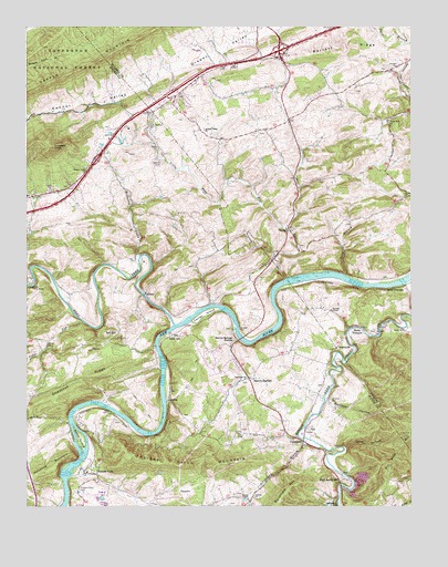
Fosters Falls, VA USGS Topographic Map
Click on map above to begin viewing in our Map Viewer.

This topographic map contains these locations and features:
Feature Name Type Latitude Longitude GNIS ID View Map
AllisonPopulated PlaceN36.9307°W80.8362°1494810View Map
Alum HollowValleyN36.8901°W80.7715°1481299View Map
Baker IslandIslandN36.8929°W80.8570°1481415View Map
Barren SpringsPopulated PlaceN36.9082°W80.8006°1494823View Map
Barren Springs Post OfficePost OfficeN36.9070°W80.8020°2766440View Map
Barren Springs StationLocaleN36.9187°W80.8067°1481474View Map
Barren Springs Volunteer Fire DepartmentBuildingN36.8985°W80.7928°2085842View Map
Barrett RidgeRidgeN36.9948°W80.7706°1481475View Map
BerthaPopulated PlaceN36.9023°W80.8284°1494838View Map
Boom FurnacePopulated PlaceN36.9207°W80.7692°1494845View Map
Brick ChurchChurchN36.8982°W80.8740°1481981View Map
Buckeye HollowValleyN36.9029°W80.7771°1482127View Map
BuddlePopulated PlaceN36.9182°W80.8481°1501276View Map
Camp Carry BrookLocaleN36.9332°W80.8729°1482250View Map
Carter Ferry (historical)CrossingN36.9162°W80.8323°1501277View Map
Carter IslandIslandN36.9254°W80.8170°1482351View Map
Cedar RunStreamN36.9229°W80.8562°1482414View Map
Charity ChurchChurchN36.8773°W80.8009°1482453View Map
Chestnut RidgeRidgeN36.9060°W80.8598°1482495View Map
Chestnut Ridge School (historical)SchoolN36.9051°W80.8715°1501281View Map
Clarks Mill ChurchChurchN36.9748°W80.7573°1482550View Map
Connor ValleyValleyN36.9827°W80.8452°1482684View Map
Crockett KnobSummitN36.9685°W80.8662°1482844View Map
Draper ValleyBasinN36.9937°W80.8117°1483085View Map
Draper Valley ChurchChurchN36.9632°W80.8548°1483086View Map
Draper Valley ChurchChurchN36.9732°W80.8167°1483087View Map
Drapers Valley CemeteryCemeteryN36.9634°W80.8559°1501291View Map
Dry Pond MountainSummitN36.8860°W80.7567°1494902View Map
Foster Falls United Methodist ChurchChurchN36.8837°W80.8531°1501304View Map
Fosters FallsPopulated PlaceN36.8835°W80.8523°1494939View Map
Fosters Falls CemeteryCemeteryN36.8798°W80.8579°1483508View Map
Fosters Falls MountainSummitN36.8857°W80.8117°1483509View Map
GlenwoodPopulated PlaceN36.9085°W80.8029°1501309View Map
Glenwood ChurchChurchN36.9076°W80.8026°1483674View Map
Graham CemeteryCemeteryN36.9171°W80.8690°1483736View Map
Graham School (historical)SchoolN36.9762°W80.7895°1501435View Map
Hematite MountainSummitN36.8837°W80.8704°1484026View Map
High Rocks ChurchChurchN36.8754°W80.7742°1484092View Map
High Rocks MillPopulated PlaceN36.8812°W80.7729°1484093View Map
Interchange 86CrossingN36.9654°W80.8520°1501328View Map
Interchange 89CrossingN36.9937°W80.7926°1501442View Map
JettPopulated PlaceN36.8951°W80.7840°1484446View Map
Johnson CemeteryCemeteryN36.9893°W80.7540°1484478View Map
Johnson ChapelChurchN36.9260°W80.7759°1484479View Map
KayoulahPopulated PlaceN36.9165°W80.7740°1495011View Map
Leander Sanders Calfee Memorial BridgeBridgeN36.9190°W80.8051°1501337View Map
Little Pine RunStreamN36.9473°W80.7892°1484956View Map
Lone AshPopulated PlaceN36.9193°W80.8279°1485033View Map
Low Gap School (historical)SchoolN36.8779°W80.7562°1501342View Map
McGavock CreekStreamN36.9390°W80.8384°1485295View Map
Oglesby CemeteryCemeteryN36.9646°W80.8301°1485953View Map
Oglesby School (historical)SchoolN36.9776°W80.8334°1501461View Map
PattersonPopulated PlaceN36.8907°W80.7851°1495085View Map
Periwinkle BranchStreamN36.8926°W80.7848°1486142View Map
Periwinkle MountainSummitN36.8790°W80.7901°1495089View Map
Pickett ChapelChurchN36.8771°W80.8029°1486185View Map
Pine RunStreamN36.9346°W80.7904°1486226View Map
Pine Run ChurchChurchN36.9476°W80.7904°1486229View Map
Red HillPopulated PlaceN36.9210°W80.8476°1495105View Map
Reed CreekStreamN36.9223°W80.8265°1486554View Map
Reed JunctionPopulated PlaceN36.9315°W80.7520°1495107View Map
Sayer School (historical)SchoolN36.9257°W80.8281°1501366View Map
Smith ChurchChurchN36.9210°W80.7526°1487338View Map
Star CavePopulated PlaceN36.9154°W80.7892°1501369View Map
Swan BranchStreamN36.9348°W80.7712°1487747View Map
Sylvatus QuarryMineN36.8825°W80.7656°2724865View Map

Note: Coordinates in the location and feature list above are referenced to NAD83 datum.


Copyright (C) 2008-2025 Ryan Niemi / Sunset Dynamics ... All Rights Reserved