TopoQuest Logo
Do you find TopoQuest useful?
Help keep TopoQuest running and adding new maps/features by donating!
Bitcoin:  19c7KJd3qBynnjoSw5npx9KScwjBe4ifkT
Litecoin:  LXs6TkuXGGXo1vDsWCkWVdjQX94eUKd6ui
Home View Maps Find Maps Find Places Resources & Links


McAdams, Mississippi Topographic Map

USGS Map Title: McAdams, MS
USGS Map MRC: 33089A6
DRG (GeoTIFF) Download: o33089a6.tif


Neighboring USGS Topographic Map Quads:


  West, MS  
33089B7
 

  Hesterville, MS  
33089B6
 

  Kosciusko NE, MS  
33089B5
 

  Durant, MS  
33089A7
 

  McAdams, MS  
33089A6
 

  Kosciusko, MS  
33089A5
 

  Newport, MS  
32089H7
 

  Joseph, MS  
32089H6
 

  Singleton, MS  
32089H5


Map MRC Location:

N34°
W90°
N34°
W89°
H8 H7 H6 H5 H4 H3 H2 H1
G8 G7 G6 G5 G4 G3 G2 G1
F8 F7 F6 F5 F4 F3 F2 F1
E8 E7 E6 E5 E4 E3 E2 E1
D8 D7 D6 D5 D4 D3 D2 D1
C8 C7 C6 C5 C4 C3 C2 C1
B8 B7 B6 B5 B4 B3 B2 B1
A8 A7 A6 A5 A4 A3 A2 A1
N33°
W90°
N33°
W89°

McAdams, MS USGS 1:24K Topographic Map Preview:
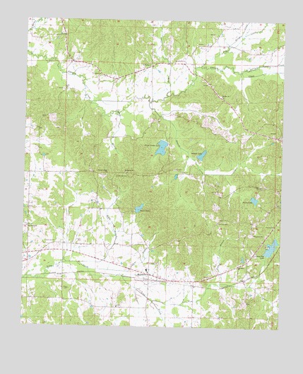
McAdams, MS USGS Topographic Map
Click on map above to begin viewing in our Map Viewer.

This topographic map contains these locations and features:
Feature Name Type Latitude Longitude GNIS ID View Map
Atwood CreekStreamN33.0918°W89.6901°666421View Map
Atwood LakeReservoirN33.0704°W89.6641°666422View Map
Baddie CreekStreamN33.0940°W89.6812°666447View Map
Bailey Atwood Lake DamDamN33.0651°W89.6584°681823View Map
Bailey LakeReservoirN33.0523°W89.6380°666462View Map
Bailey Lake DamDamN33.0535°W89.6401°681818View Map
Bethlehem CemeteryCemeteryN33.0612°W89.7054°666980View Map
Bethlehem ChurchChurchN33.0632°W89.7012°667004View Map
Black BranchStreamN33.0874°W89.7056°667205View Map
Bluff Springs (historical)Populated PlaceN33.0335°W89.7348°710839View Map
Brown CemeteryCemeteryN33.0154°W89.7276°667619View Map
Burrel LakeReservoirN33.0485°W89.6937°667836View Map
Burrell Lake DamDamN33.0468°W89.6951°681810View Map
Center Point (historical)Populated PlaceN33.0849°W89.6459°710858View Map
Center Point School (historical)SchoolN33.0860°W89.6465°710859View Map
Clear BranchStreamN33.0235°W89.7179°668544View Map
Coleman CemeteryCemeteryN33.0262°W89.6837°668674View Map
Country Club LakeReservoirN33.0334°W89.6292°668861View Map
Country Club Lake DamDamN33.0301°W89.6317°681793View Map
Cummings CemeteryCemeteryN33.0346°W89.7342°690911View Map
EarlyvillePopulated PlaceN33.0771°W89.7098°711185View Map
Hosspen CreekStreamN33.1143°W89.6520°671512View Map
HurricanePopulated PlaceN33.0251°W89.6451°710898View Map
Hurricane Baptist ChurchChurchN33.0246°W89.6454°671607View Map
Hurricane CemeteryCemeteryN33.0423°W89.6554°671606View Map
J Steed Lake DamDamN33.0301°W89.6867°681794View Map
Kenneth Love Lake DamDamN33.1118°W89.6384°681859View Map
Kosciusko Country ClubLocaleN33.0346°W89.6323°690023View Map
Little Apookta CreekStreamN33.1040°W89.6454°672529View Map
Long Creek Structure 11 DamDamN33.0135°W89.6334°681785View Map
Long Creek Structure Number 7 DamDamN33.0518°W89.7051°681815View Map
Long Creek Watershed Structure 14 DamDamN33.0201°W89.7217°681788View Map
McAdamsPopulated PlaceN33.0212°W89.6884°673282View Map
McAdams Baptist ChurchChurchN33.0224°W89.6890°710923View Map
McAdams High SchoolSchoolN33.0232°W89.6898°710924View Map
McAdams Methodist ChurchChurchN33.0235°W89.6884°710925View Map
Mississippi No Name 6 DamDamN33.0751°W89.6817°681831View Map
Mississippi No Name 7 DamDamN33.0685°W89.6651°681825View Map
Mount Zion CemeteryCemeteryN33.0940°W89.6542°710937View Map
Mount Zion ChurchChurchN33.0943°W89.6545°674372View Map
Musselwhite CemeteryCemeteryN33.1090°W89.6773°674490View Map
New Bethel CemeteryCemeteryN33.0410°W89.7429°710944View Map
New Bethel ChurchChurchN33.0407°W89.7481°674580View Map
Pleasant Ridge (historical)Populated PlaceN33.0626°W89.7167°710979View Map
Pleasant Ridge Baptist ChurchChurchN33.0624°W89.7098°676114View Map
Pleasant Ridge CemeteryCemeteryN33.0621°W89.7123°710980View Map
Pleasant Ridge School (historical)SchoolN33.0626°W89.7104°710981View Map
Pony BranchStreamN33.0104°W89.6862°676200View Map
Silas Grove CemeteryCemeteryN33.0376°W89.6379°711006View Map
Silas Grove ChurchChurchN33.0379°W89.6379°677774View Map
SpringdalePopulated PlaceN33.1074°W89.6876°711014View Map
Springdale Baptist ChurchChurchN33.1068°W89.6895°678165View Map
Springdale CemeteryCemeteryN33.1026°W89.7142°678164View Map
Springdale Methodist Church (historical)ChurchN33.1029°W89.7137°711015View Map
Springdale School (historical)SchoolN33.1071°W89.6892°711016View Map
Sugar CreekStreamN33.1062°W89.6651°678385View Map
Teague CemeteryCemeteryN33.0346°W89.7217°678610View Map
Thweatt (historical)Populated PlaceN33.0196°W89.6429°711027View Map
Ward BranchStreamN33.0260°W89.7234°679331View Map
Weeks Post Office (historical)Post OfficeN33.0724°W89.7434°712972View Map
Youth Center LakeReservoirN33.0732°W89.6836°679976View Map

Note: Coordinates in the location and feature list above are referenced to NAD83 datum.


Copyright (C) 2008-2025 Ryan Niemi / Sunset Dynamics ... All Rights Reserved