TopoQuest Logo
Do you find TopoQuest useful?
Help keep TopoQuest running and adding new maps/features by donating!
Bitcoin:  19c7KJd3qBynnjoSw5npx9KScwjBe4ifkT
Litecoin:  LXs6TkuXGGXo1vDsWCkWVdjQX94eUKd6ui
Home View Maps Find Maps Find Places Resources & Links


Newport, Mississippi Topographic Map

USGS Map Title: Newport, MS
USGS Map MRC: 32089H7
DRG (GeoTIFF) Download: o32089h7.tif


Neighboring USGS Topographic Map Quads:


  Owens Wells, MS  
33089A8
 

  Durant, MS  
33089A7
 

  McAdams, MS  
33089A6
 

  Goodman, MS  
32089H8
 

  Newport, MS  
32089H7
 

  Joseph, MS  
32089H6
 

  Cameron, MS  
32089G8
 

  Camden, MS  
32089G7
 

  Thomastown, MS  
32089G6


Map MRC Location:

N33°
W90°
N33°
W89°
H8 H7 H6 H5 H4 H3 H2 H1
G8 G7 G6 G5 G4 G3 G2 G1
F8 F7 F6 F5 F4 F3 F2 F1
E8 E7 E6 E5 E4 E3 E2 E1
D8 D7 D6 D5 D4 D3 D2 D1
C8 C7 C6 C5 C4 C3 C2 C1
B8 B7 B6 B5 B4 B3 B2 B1
A8 A7 A6 A5 A4 A3 A2 A1
N32°
W90°
N32°
W89°

Newport, MS USGS 1:24K Topographic Map Preview:
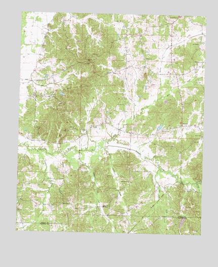
Newport, MS USGS Topographic Map
Click on map above to begin viewing in our Map Viewer.

This topographic map contains these locations and features:
Feature Name Type Latitude Longitude GNIS ID View Map
Ables CemeteryCemeteryN32.9732°W89.8498°690902View Map
Big Black School (historical)SchoolN32.9460°W89.8459°710837View Map
Black Jack CemeteryCemeteryN32.9007°W89.8131°690905View Map
Bolatusha CreekStreamN32.9040°W89.7537°667402View Map
Branchville (historical)Populated PlaceN32.9321°W89.8306°710845View Map
Center Ridge ChurchChurchN32.9662°W89.7845°668257View Map
Crooked CreekStreamN32.9210°W89.8620°668957View Map
Deer Lake CreekStreamN32.9124°W89.7790°669201View Map
Dickerson CemeteryCemeteryN32.9660°W89.8176°669256View Map
Francis Lake DamDamN32.9551°W89.8467°681758View Map
Harmonia CemeteryCemeteryN32.9748°W89.7904°710891View Map
Harmonia Methodist ChurchChurchN32.9749°W89.7909°670923View Map
Hopewell CemeteryCemeteryN32.9043°W89.7973°710897View Map
Hopewell ChurchChurchN32.9046°W89.8012°671427View Map
Horton CreekStreamN32.9507°W89.7845°671508View Map
Lutheran CemeteryCemeteryN32.9732°W89.8306°672965View Map
May CreekStreamN32.9507°W89.7845°673257View Map
McClain CemeteryCemeteryN32.9321°W89.7512°673298View Map
McDaniel Lake DamDamN32.9551°W89.7767°681757View Map
Midway School (historical)SchoolN32.8882°W89.8298°710929View Map
New Banyon CemeteryCemeteryN32.9618°W89.8581°710943View Map
New Banyon ChurchChurchN32.9610°W89.8642°674565View Map
New Hope (historical)Populated PlaceN32.9849°W89.7542°710947View Map
New Hope Baptist ChurchChurchN32.9843°W89.7548°674705View Map
New Hope CemeteryCemeteryN32.9846°W89.7551°710948View Map
New Roby CemeteryCemeteryN32.9346°W89.7784°674823View Map
NewportPopulated PlaceN32.9371°W89.7645°674907View Map
Old Roby CemeteryCemeteryN32.9490°W89.8056°675242View Map
Ousley CreekStreamN32.9040°W89.7537°675335View Map
Parker CreekStreamN32.9237°W89.8181°675462View Map
Pisgah CemeteryCemeteryN32.9768°W89.8240°675933View Map
Pole Pen CemeteryCemeteryN32.9343°W89.8601°676178View Map
Roby CemeteryCemeteryN32.9351°W89.8248°676737View Map
Roby CreekStreamN32.9237°W89.8181°676738View Map
Roy Barrett Lake DamDamN32.8835°W89.7634°681723View Map
Saint Mark CemeteryCemeteryN32.9343°W89.8379°710991View Map
Saint Mark ChurchChurchN32.9346°W89.8381°677123View Map
Salem CemeteryCemeteryN32.9282°W89.7567°677264View Map
Sallis Lookout TowerTowerN32.9718°W89.8290°711307View Map
Sandy Ridge CemeteryCemeteryN32.8912°W89.8434°710997View Map
Sandy Ridge ChurchChurchN32.8910°W89.8434°677392View Map
Seneasha CemeteryCemeteryN32.9340°W89.8315°710998View Map
Seneasha ChurchChurchN32.9337°W89.8329°677515View Map
Seneasha School (historical)SchoolN32.9337°W89.8323°710999View Map
Shrock (historical)Populated PlaceN32.8876°W89.8748°711004View Map
Shrock Methodist ChurchChurchN32.8868°W89.8748°677754View Map
Shrock School (historical)SchoolN32.8865°W89.8745°711005View Map
Smithson Lake DamDamN32.9351°W89.7801°681746View Map
Spring Grove CemeteryCemeteryN32.8887°W89.8170°711012View Map
Spring Grove Methodist ChurchChurchN32.8901°W89.8165°678094View Map
Spring Ridge CemeteryCemeteryN32.9987°W89.7695°678156View Map
Steward CreekStreamN32.9212°W89.8351°678278View Map
Supervisor District 4CivilN32.9808°W89.7699°711777View Map
Unger DitchCanalN32.9590°W89.8645°679030View Map
Union CemeteryCemeteryN32.8979°W89.8459°690940View Map
Waugh Post Office (historical)Post OfficeN32.9101°W89.7834°712971View Map
Wyatt CemeteryCemeteryN32.9076°W89.8112°679898View Map
Wyse CemeteryCemeteryN32.9740°W89.7537°679907View Map

Note: Coordinates in the location and feature list above are referenced to NAD83 datum.


Copyright (C) 2008-2025 Ryan Niemi / Sunset Dynamics ... All Rights Reserved