TopoQuest Logo
Do you find TopoQuest useful?
Help keep TopoQuest running and adding new maps/features by donating!
Bitcoin:  19c7KJd3qBynnjoSw5npx9KScwjBe4ifkT
Litecoin:  LXs6TkuXGGXo1vDsWCkWVdjQX94eUKd6ui
Home View Maps Find Maps Find Places Resources & Links


McBride, Mississippi Topographic Map

USGS Map Title: McBride, MS
USGS Map MRC: 31090G7
DRG (GeoTIFF) Download: o31090g7.tif


Neighboring USGS Topographic Map Quads:


  Port Gibson, MS  
31090H8
 

  Hermanville, MS  
31090H7
 

  Dentville NW, MS  
31090H6
 

  Red Lick, MS  
31090G8
 

  McBride, MS  
31090G7
 

  Barlow, MS  
31090G6
 

  Gin Branch, MS  
31090F8
 

  Union Church, MS  
31090F7
 

  Caseyville, MS  
31090F6


Map MRC Location:

N32°
W91°
N32°
W90°
H8 H7 H6 H5 H4 H3 H2 H1
G8 G7 G6 G5 G4 G3 G2 G1
F8 F7 F6 F5 F4 F3 F2 F1
E8 E7 E6 E5 E4 E3 E2 E1
D8 D7 D6 D5 D4 D3 D2 D1
C8 C7 C6 C5 C4 C3 C2 C1
B8 B7 B6 B5 B4 B3 B2 B1
A8 A7 A6 A5 A4 A3 A2 A1
N31°
W91°
N31°
W90°

McBride, MS USGS 1:24K Topographic Map Preview:
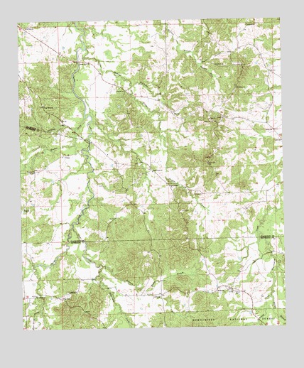
McBride, MS USGS Topographic Map
Click on map above to begin viewing in our Map Viewer.

This topographic map contains these locations and features:
Feature Name Type Latitude Longitude GNIS ID View Map
Antioch CemeteryCemeteryN31.7646°W90.7734°692403View Map
Antioch ChurchChurchN31.7646°W90.7748°692406View Map
Beech Grove Baptist ChurchChurchN31.8138°W90.8118°692526View Map
Beech Grove School (historical)SchoolN31.8066°W90.8034°705263View Map
Blue Goose CreekStreamN31.7577°W90.8668°692642View Map
Blue HillPopulated PlaceN31.7629°W90.8576°692643View Map
Blue Hill ChurchChurchN31.7632°W90.8682°692644View Map
Buckins CreekStreamN31.8638°W90.8426°692746View Map
Clarks Creek ChurchChurchN31.8585°W90.8412°692919View Map
Clarks Creek School (historical)SchoolN31.8585°W90.8423°705264View Map
Crow CreekStreamN31.7916°W90.8504°693020View Map
Forest Grove ChurchChurchN31.8407°W90.8632°693244View Map
Forest Grove School (historical)SchoolN31.8413°W90.8640°705265View Map
Foster CreekStreamN31.7621°W90.7568°693253View Map
Griffing BranchStreamN31.8310°W90.8484°693375View Map
Hedrich CemeteryCemeteryN31.8465°W90.8282°693444View Map
Herlong CemeteryCemeteryN31.8043°W90.7884°693452View Map
Hervey (historical)Populated PlaceN31.8640°W90.7612°705266View Map
Hughes CreekStreamN31.8357°W90.8434°693557View Map
Johnson CreekStreamN31.7757°W90.8370°693627View Map
Martinsville School (historical)SchoolN31.8646°W90.7637°705267View Map
Mason BranchStreamN31.7646°W90.8165°693887View Map
McBridePopulated PlaceN31.7657°W90.7823°692054View Map
Middleton Lake DamDamN31.8635°W90.8534°695411View Map
Mount Pleasant Baptist ChurchChurchN31.8477°W90.7712°694096View Map
Old Sarepta Baptist ChurchChurchN31.8724°W90.7654°694717View Map
Owens BranchStreamN31.8571°W90.7890°694287View Map
PeytonPopulated PlaceN31.8377°W90.8023°694352View Map
Peyton Lookout TowerTowerN31.8332°W90.7812°711289View Map
Philadelphia Baptist ChurchChurchN31.8079°W90.8037°694355View Map
Pierce BranchStreamN31.7621°W90.7568°694365View Map
Pine Ridge School (historical)SchoolN31.8354°W90.8043°705268View Map
Saint Johns ChurchChurchN31.8143°W90.8682°694647View Map
Saint Marks ChurchChurchN31.7652°W90.8532°694655View Map
Saint Peters Baptist ChurchChurchN31.8727°W90.8712°694674View Map
Salem ChurchChurchN31.8299°W90.7551°694679View Map
Sanders BranchStreamN31.8571°W90.7890°694700View Map
Sanders CemeteryCemeteryN31.8568°W90.7812°694701View Map
Sarepta (historical)Populated PlaceN31.8732°W90.7668°708099View Map
Sarepta CemeteryCemeteryN31.8727°W90.7662°708100View Map
Segrest CemeteryCemeteryN31.8257°W90.7501°694741View Map
Serepta School (historical)SchoolN31.8721°W90.7659°705269View Map
Singletary CreekStreamN31.7721°W90.8376°692369View Map
Supervisor District 5CivilN31.8573°W90.8303°711812View Map
Trevillion CemeteryCemeteryN31.8154°W90.8126°708107View Map
Unity ChurchChurchN31.7991°W90.8734°695059View Map
Vaughn Lake DamDamN31.8585°W90.7584°695410View Map
VioletPopulated PlaceN31.8207°W90.8529°695072View Map
Williams BranchStreamN31.8485°W90.8207°695182View Map

Note: Coordinates in the location and feature list above are referenced to NAD83 datum.


Copyright (C) 2008-2024 Ryan Niemi / Sunset Dynamics ... All Rights Reserved