TopoQuest Logo
Do you find TopoQuest useful?
Help keep TopoQuest running and adding new maps/features by donating!
Bitcoin:  19c7KJd3qBynnjoSw5npx9KScwjBe4ifkT
Litecoin:  LXs6TkuXGGXo1vDsWCkWVdjQX94eUKd6ui
Home View Maps Find Maps Find Places Resources & Links


Cape Girardeau, Missouri Topographic Map

USGS Map Title: Cape Girardeau, MO
USGS Map MRC: 37089C5
DRG (GeoTIFF) Download: o37089c5.tif


Neighboring USGS Topographic Map Quads:


  Jackson, MO  
37089D6
 

  Cape Girardeau NE, MO  
37089D5
 

  Ware, IL  
37089D4
 

  Gordonville, MO  
37089C6
 

  Cape Girardeau, MO  
37089C5
 

  McClure, IL  
37089C4
 

  Chaffee, MO  
37089B6
 

  Scott City, MO  
37089B5
 

  Thebes, IL  
37089B4


Map MRC Location:

N38°
W90°
N38°
W89°
H8 H7 H6 H5 H4 H3 H2 H1
G8 G7 G6 G5 G4 G3 G2 G1
F8 F7 F6 F5 F4 F3 F2 F1
E8 E7 E6 E5 E4 E3 E2 E1
D8 D7 D6 D5 D4 D3 D2 D1
C8 C7 C6 C5 C4 C3 C2 C1
B8 B7 B6 B5 B4 B3 B2 B1
A8 A7 A6 A5 A4 A3 A2 A1
N37°
W90°
N37°
W89°

Cape Girardeau, MO USGS 1:24K Topographic Map Preview:
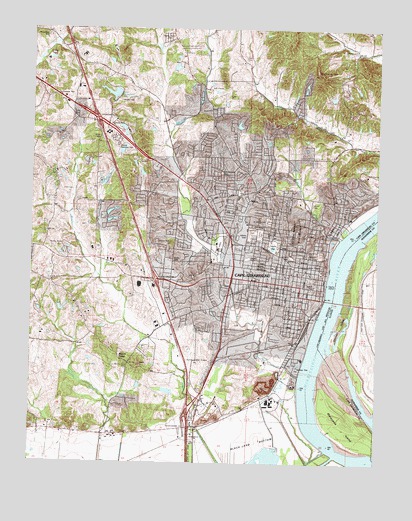
Cape Girardeau, MO USGS Topographic Map
Click on map above to begin viewing in our Map Viewer.

This topographic map contains these locations and features:
Feature Name Type Latitude Longitude GNIS ID View Map
Arena ParkParkN37.3120°W89.5570°713378View Map
Big BendBendN37.2653°W89.5243°730552View Map
Big SwampSwampN37.2514°W89.5381°730561View Map
Black Land BottomFlatN37.2578°W89.5425°714295View Map
Brown LakeReservoirN37.3552°W89.5166°765031View Map
Brown Lake DamDamN37.3551°W89.5151°765030View Map
Campster School (historical)SchoolN37.2839°W89.5856°748131View Map
Capaha ParkParkN37.3126°W89.5370°715377View Map
Cape ChapelChurchN37.3451°W89.5140°715378View Map
Cape GirardeauPopulated PlaceN37.3059°W89.5181°731549View Map
Cape Girardeau Country ClubLocaleN37.3328°W89.5037°755024View Map
Cape Girardeau Fire Department Station 1BuildingN37.3038°W89.5274°2621204View Map
Cape Girardeau Fire Department Station 2BuildingN37.2925°W89.5719°2621778View Map
Cape Girardeau Fire Department Station 3BuildingN37.3330°W89.5233°2621782View Map
Cape Girardeau Fire Department Station 4BuildingN37.3302°W89.5647°2621781View Map
Cape Girardeau Police DepartmentBuildingN37.3031°W89.5269°2752386View Map
Cape Girardeau Post OfficePost OfficeN37.3086°W89.5245°2783204View Map
Cape La Croix CreekStreamN37.2751°W89.5276°731550View Map
Cape LaCrus (historical)LocaleN37.3476°W89.5748°740318View Map
Central High SchoolSchoolN37.3078°W89.5462°715675View Map
Central Junior High SchoolSchoolN37.3103°W89.5454°715679View Map
City of Cape GirardeauCivilN37.3107°W89.5595°2393737View Map
County Memorial ParkCemeteryN37.3429°W89.5942°716386View Map
DecaturPopulated PlaceN37.2948°W89.5223°730551View Map
East County Fire Protection District Station 3 Hanover StationBuildingN37.3730°W89.5622°2620846View Map
Elmwood (historical)Populated PlaceN37.2528°W89.5815°740319View Map
Ervin CemeteryCemeteryN37.3662°W89.5481°717625View Map
Fairmon CemeteryCemeteryN37.3167°W89.5454°717739View Map
Fort A (historical)MilitaryN37.3081°W89.5175°754198View Map
Fort B (historical)MilitaryN37.3175°W89.5269°754197View Map
Franklin SchoolSchoolN37.3076°W89.5387°718169View Map
Garms LakeReservoirN37.3651°W89.5968°765026View Map
Garms Lake DamDamN37.3651°W89.5968°765025View Map
Giboney IslandIslandN37.2892°W89.5137°408987View Map
Greene SchoolSchoolN37.2898°W89.5273°718820View Map
Gulf JunctionLocaleN37.2709°W89.5376°735968View Map
Hanover ChurchChurchN37.3528°W89.5598°719059View Map
Hawthorn SchoolSchoolN37.3226°W89.5665°719244View Map
Hitt CemeteryCemeteryN37.3287°W89.6137°719640View Map
Hitt CemeteryCemeteryN37.3303°W89.6062°719641View Map
Houck StadiumParkN37.3095°W89.5309°730550View Map
Indian ParkParkN37.3006°W89.5220°720140View Map
Jefferson SchoolSchoolN37.2981°W89.5409°720280View Map
Juden DamDamN37.2851°W89.5734°765515View Map
Juden School (historical)SchoolN37.3445°W89.5140°748133View Map
Kage School (historical)SchoolN37.3303°W89.5790°731508View Map
KAPE-AM (Cape Girardeau)TowerN37.2792°W89.5579°759273View Map
KGMO-FM (Cape Girardeau)TowerN37.3712°W89.5312°754240View Map
Klaus ParkParkN37.3437°W89.6004°720660View Map
KRCU-FM (Cape Girardeau)TowerN37.3131°W89.5309°759035View Map
Lake HollenbeckReservoirN37.3551°W89.5934°758291View Map
Lake Hollenbeck DamDamN37.3551°W89.5934°765555View Map
Lake Tanglewood NorthReservoirN37.3591°W89.5261°765035View Map
Lake Tanglewood North DamDamN37.3584°W89.5268°765034View Map
Lake Tanglewood SouthReservoirN37.3574°W89.5266°765033View Map
Lake Tanglewood South DamDamN37.3567°W89.5268°765032View Map
Landmark Hospital of Cape GirardeauHospitalN37.3079°W89.5759°2655120View Map
Little Bear Lake DamDamN37.3467°W89.5501°764358View Map
Little Ponderosa LakeReservoirN37.3317°W89.5851°765029View Map
Little Ponderosa Lake DamDamN37.3317°W89.5851°765028View Map
Lorimer SchoolSchoolN37.3034°W89.5229°721572View Map
Marquette Cement Quarry and PlantMineN37.2731°W89.5390°740072View Map
Marquette IslandIslandN37.2614°W89.5140°721892View Map
Marquette SchoolSchoolN37.2653°W89.5493°721894View Map
McKendree CemeteryCemeteryN37.3723°W89.6201°722126View Map
Minton CemeteryCemeteryN37.3687°W89.5087°722453View Map
Missouri Department of Conservation Forestry Southeast Regional Field Fire Office Cape GirardeauBuildingN37.3455°W89.5901°2621783View Map
Missouri ParkParkN37.3098°W89.5206°722477View Map
Mount Auburn CemeteryCemeteryN37.3128°W89.5740°722710View Map
Mount TaborSummitN37.2792°W89.5904°755332View Map
Mount Tabor ParkParkN37.2773°W89.5893°722903View Map
New Lorimier CemeteryCemeteryN37.3162°W89.5423°721573View Map
North Twin LakeReservoirN37.3221°W89.5968°765024View Map
North Twin Lakes DamDamN37.3217°W89.5984°765023View Map
Notre Dame High SchoolSchoolN37.3153°W89.5448°723528View Map
Nunn CemeteryCemeteryN37.3081°W89.5715°723544View Map
Old Hanover CemeteryCemeteryN37.3337°W89.5568°723753View Map
Pecan Grove SchoolSchoolN37.2601°W89.6209°724163View Map
Pleasant Valley School (historical)SchoolN37.2764°W89.5826°748132View Map
Ranney CreekStreamN37.2501°W89.5995°725104View Map
Rock LeveeLocaleN37.2637°W89.5668°735983View Map
Rock LeveeLocaleN37.2656°W89.5475°730553View Map
Rock Levee School (historical)SchoolN37.2678°W89.5443°748134View Map
Rush Hudson Limbaugh Sr., United States CourthouseBuildingN37.3036°W89.5248°2111038View Map
Saint Francis Hospital HeliportAirportN37.3028°W89.5709°758623View Map
Saint Francis Medical CenterHospitalN37.3034°W89.5713°2655070View Map
Saint Mary's CemeteryCemeteryN37.3198°W89.5393°725831View Map
Saint Marys SchoolSchoolN37.3006°W89.5273°725847View Map
Saint Vincents ChurchChurchN37.3006°W89.5195°730549View Map
Saint Vincents CollegeSchoolN37.2962°W89.5212°725912View Map
Salem CemeteryCemeteryN37.3234°W89.6173°725920View Map
Schrader SchoolSchoolN37.3281°W89.5540°726118View Map
Schultz SchoolSchoolN37.3034°W89.5309°726124View Map
Sloan CreekStreamN37.3148°W89.5134°726556View Map
Southeast HospitalHospitalN37.3107°W89.5403°2655082View Map
Southeast Missouri Hospital HeliportAirportN37.3109°W89.5404°758624View Map
Southeast Missouri State UniversitySchoolN37.3126°W89.5309°726803View Map
State Training SchoolSchoolN37.3453°W89.5906°727040View Map
Town PlazaLocaleN37.3039°W89.5498°736104View Map
Township of Cape GirardeauCivilN37.2938°W89.5779°766397View Map
Trinity SchoolSchoolN37.3056°W89.5306°727793View Map
Upper Whitewater CreekStreamN37.2519°W89.5147°756905View Map
Washington SchoolSchoolN37.3126°W89.5218°728377View Map
West Park MallLocaleN37.3042°W89.5779°736103View Map

Note: Coordinates in the location and feature list above are referenced to NAD83 datum.


Copyright (C) 2008-2024 Ryan Niemi / Sunset Dynamics ... All Rights Reserved