TopoQuest Logo
Do you find TopoQuest useful?
Help keep TopoQuest running and adding new maps/features by donating!
Bitcoin:  19c7KJd3qBynnjoSw5npx9KScwjBe4ifkT
Litecoin:  LXs6TkuXGGXo1vDsWCkWVdjQX94eUKd6ui
Home View Maps Find Maps Find Places Resources & Links


Sturdivant, Missouri Topographic Map

USGS Map Title: Sturdivant, MO
USGS Map MRC: 37090A1
DRG (GeoTIFF) Download: o37090a1.tif


Neighboring USGS Topographic Map Quads:


  Gipsy, MO  
37090B2
 

  Zalma, MO  
37090B1
 

  Dongola, MO  
37089B8
 

  McGee, MO  
37090A2
 

  Sturdivant, MO  
37090A1
 

  Advance, MO  
37089A8
 

  Puxico, MO  
36090H2
 

  Acorn Ridge, MO  
36090H1
 

  Bloomfield, MO  
36089H8


Map MRC Location:

N38°
W91°
N38°
W90°
H8 H7 H6 H5 H4 H3 H2 H1
G8 G7 G6 G5 G4 G3 G2 G1
F8 F7 F6 F5 F4 F3 F2 F1
E8 E7 E6 E5 E4 E3 E2 E1
D8 D7 D6 D5 D4 D3 D2 D1
C8 C7 C6 C5 C4 C3 C2 C1
B8 B7 B6 B5 B4 B3 B2 B1
A8 A7 A6 A5 A4 A3 A2 A1
N37°
W91°
N37°
W90°

Sturdivant, MO USGS 1:24K Topographic Map Preview:
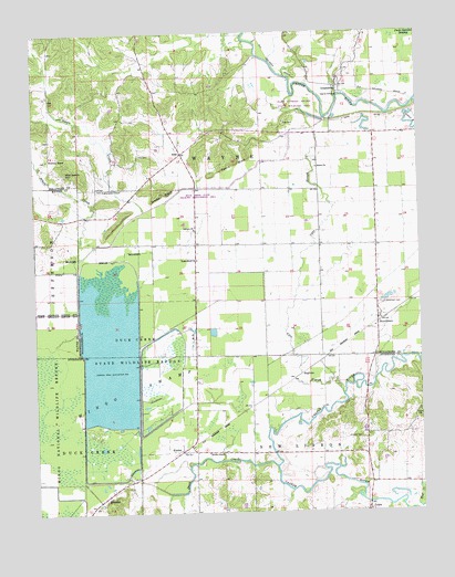
Sturdivant, MO USGS Topographic Map
Click on map above to begin viewing in our Map Viewer.

This topographic map contains these locations and features:
Feature Name Type Latitude Longitude GNIS ID View Map
Abernathy ChapelChurchN37.0842°W90.1020°713125View Map
Acuff and Ayers LakeReservoirN37.1201°W90.1201°764472View Map
Acuff and Ayers Lake DamDamN37.1201°W90.1201°764471View Map
ArabPopulated PlaceN37.0709°W90.1195°739922View Map
ArabPopulated PlaceN37.0937°W90.0768°740630View Map
Bethel ChurchChurchN37.0898°W90.0329°714046View Map
Brush CreekStreamN37.0703°W90.1109°714862View Map
Brush Creek ChurchChurchN37.0887°W90.1140°714869View Map
Calvary ChurchChurchN37.0739°W90.0729°715218View Map
Cato CemeteryCemeteryN37.1017°W90.0431°715500View Map
Cato SloughStreamN37.0306°W90.0254°715502View Map
Cato SloughSwampN37.1042°W90.0390°730536View Map
Cox CemeteryCemeteryN37.0931°W90.0906°716422View Map
Cox Chapel (historical)ChurchN37.0931°W90.0915°748031View Map
Dark Cypress Swamp State Wildlife AreaParkN37.1042°W90.0387°743194View Map
Ditch Number 1CanalN37.0126°W90.1104°755054View Map
Duck CreekStreamN37.0120°W90.0473°717140View Map
Duck Creek Conservation AreaParkN37.0423°W90.0965°717144View Map
Duck Creek State Wildlife Management AreaParkN37.0826°W90.0782°743193View Map
Duck Creek State Wildlife Refuge Number 1 DamDamN37.0217°W90.1018°765570View Map
Duck Creek State Wildlife Refuge Number 2 DamDamN37.0201°W90.0901°765593View Map
Duck Creek State Wildlife Refuge Number 3 DamDamN37.0084°W90.1101°765594View Map
EaglettePopulated PlaceN37.0356°W90.0395°740821View Map
Eastern Ozark BorderAreaN37.1206°W90.0334°760178View Map
Ellison LakeReservoirN37.0101°W90.0318°765533View Map
Fears BluffCliffN37.0909°W90.0590°717870View Map
Foleys (historical)LocaleN37.0309°W90.0490°740567View Map
Grapevine RidgeRidgeN37.0470°W90.0762°739923View Map
GreenbrierPopulated PlaceN37.1106°W90.0257°718819View Map
Greenbrier SchoolSchoolN37.1242°W90.0162°748034View Map
Headquarters (historical)LocaleN37.0112°W90.0865°748033View Map
IdlewildPopulated PlaceN37.0037°W90.1040°720071View Map
Kimbrel CemeteryCemeteryN37.0195°W90.0198°720585View Map
KinderPopulated PlaceN37.0159°W90.0782°739996View Map
Kinder ChapelChurchN37.0156°W90.0693°720598View Map
LeoraPopulated PlaceN37.0003°W90.0182°720916View Map
Mononame 468 DamDamN37.0934°W90.1184°764466View Map
Pool EightSwampN37.0309°W90.1245°738121View Map
RichardsonLocaleN37.1064°W90.0168°736184View Map
Slagle CreekStreamN37.0662°W90.1107°726526View Map
Slagle SchoolSchoolN37.1098°W90.0859°748030View Map
Snake BluffCliffN37.0828°W90.0829°726653View Map
Snake Bluff ChurchChurchN37.0659°W90.0723°726654View Map
Snake Bluff SchoolSchoolN37.0848°W90.0862°748032View Map
Stepp School (historical)SchoolN37.0951°W90.0334°755532View Map
Stratman ChapelChurchN37.0926°W90.1207°727172View Map
Strobel Lake DamDamN37.0101°W90.0318°765532View Map
SturdivantPopulated PlaceN37.0495°W90.0140°727203View Map
Sturdivant CemeteryCemeteryN37.0542°W90.0118°727204View Map
Sturdivant Post OfficePost OfficeN37.0506°W90.0128°2782991View Map
Township of WayneCivilN37.1165°W90.0882°766327View Map
Ward DamDamN37.1234°W90.0834°764462View Map
Ward LakeReservoirN37.1234°W90.0834°764463View Map

Note: Coordinates in the location and feature list above are referenced to NAD83 datum.


Copyright (C) 2008-2024 Ryan Niemi / Sunset Dynamics ... All Rights Reserved