TopoQuest Logo
Do you find TopoQuest useful?
Help keep TopoQuest running and adding new maps/features by donating!
Bitcoin:  19c7KJd3qBynnjoSw5npx9KScwjBe4ifkT
Litecoin:  LXs6TkuXGGXo1vDsWCkWVdjQX94eUKd6ui
Home View Maps Find Maps Find Places Resources & Links


Zalma, Missouri Topographic Map

USGS Map Title: Zalma, MO
USGS Map MRC: 37090B1
DRG (GeoTIFF) Download: o37090b1.tif


Neighboring USGS Topographic Map Quads:


  Allbright, MO  
37090C2
 

  Glenallen, MO  
37090C1
 

  Marble Hill, MO  
37089C8
 

  Gipsy, MO  
37090B2
 

  Zalma, MO  
37090B1
 

  Dongola, MO  
37089B8
 

  McGee, MO  
37090A2
 

  Sturdivant, MO  
37090A1
 

  Advance, MO  
37089A8


Map MRC Location:

N38°
W91°
N38°
W90°
H8 H7 H6 H5 H4 H3 H2 H1
G8 G7 G6 G5 G4 G3 G2 G1
F8 F7 F6 F5 F4 F3 F2 F1
E8 E7 E6 E5 E4 E3 E2 E1
D8 D7 D6 D5 D4 D3 D2 D1
C8 C7 C6 C5 C4 C3 C2 C1
B8 B7 B6 B5 B4 B3 B2 B1
A8 A7 A6 A5 A4 A3 A2 A1
N37°
W91°
N37°
W90°

Zalma, MO USGS 1:24K Topographic Map Preview:
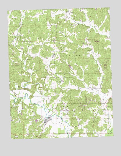
Zalma, MO USGS Topographic Map
Click on map above to begin viewing in our Map Viewer.

This topographic map contains these locations and features:
Feature Name Type Latitude Longitude GNIS ID View Map
Antioch ChurchChurchN37.2192°W90.1054°713327View Map
Balch ChurchChurchN37.1545°W90.0143°713583View Map
Barks LakeReservoirN37.2134°W90.1084°764461View Map
Barks Lake DamDamN37.2134°W90.1084°764460View Map
Cane Creek CemeteryCemeteryN37.2470°W90.0487°715344View Map
Cane Creek SchoolSchoolN37.2403°W90.0295°748082View Map
Castor Bridge (historical)BridgeN37.1323°W90.0540°748087View Map
Club Creek State ForestForestN37.1642°W90.0287°742803View Map
Clubb CreekStreamN37.1681°W90.0170°716019View Map
Clubb Creek ChurchChurchN37.2089°W90.0237°716020View Map
Clubb Creek SchoolSchoolN37.2098°W90.0229°748083View Map
Crites CemeteryCemeteryN37.2320°W90.0165°716504View Map
Cypress PondSwampN37.1755°W90.1166°716626View Map
Eaker School (historical)SchoolN37.1928°W90.0779°748079View Map
Eakers CemeteryCemeteryN37.1939°W90.0737°717237View Map
Greenwood SchoolSchoolN37.1745°W90.0284°748084View Map
Hable DamDamN37.2467°W90.0701°764687View Map
HahnPopulated PlaceN37.2053°W90.0698°718976View Map
Hall ChurchChurchN37.1464°W90.1220°719005View Map
Hall School (historical)SchoolN37.1473°W90.1232°748081View Map
James School (historical)SchoolN37.1609°W90.0612°748085View Map
Ladd ChapelChurchN37.1537°W90.0076°720729View Map
Ladd School (historical)SchoolN37.1470°W90.0115°748086View Map
Mitz BranchStreamN37.1603°W90.1193°722501View Map
Myers School (historical)SchoolN37.1728°W90.1015°748080View Map
Patterson CemeteryCemeteryN37.2228°W90.1145°724084View Map
Patterson SchoolSchoolN37.2231°W90.1037°748078View Map
Perkins CreekStreamN37.1584°W90.0923°724228View Map
Point Pleasant ChurchChurchN37.2462°W90.0490°731634View Map
SankPopulated PlaceN37.1717°W90.0137°741240View Map
Sank State Wildlife AreaParkN37.1601°W90.0034°742802View Map
Sherman Lake DamDamN37.1434°W90.0918°764683View Map
Shoal HillSummitN37.1626°W90.1134°726396View Map
Speer CemeteryCemeteryN37.1692°W90.0551°726841View Map
Sweetgum Public Access AreaLocaleN37.1681°W90.1184°742804View Map
Talley BranchStreamN37.1642°W90.1082°727442View Map
Taylor Bayless DamDamN37.1934°W90.0501°764923View Map
Union Hill ChurchChurchN37.1795°W90.0643°728021View Map
Village of Zalma (historical)CivilN37.1432°W90.0804°2399756View Map
Virgin CreekStreamN37.1712°W90.0270°728213View Map
Virgin Creek LakeReservoirN37.1940°W90.0508°764924View Map
White CemeteryCemeteryN37.1784°W90.0920°728716View Map
Wonder Lake - Field Visit 1979ReservoirN37.1423°W90.0937°764684View Map
ZalmaPopulated PlaceN37.1448°W90.0762°729220View Map
Zalma Census Designated PlaceCensusN37.1419°W90.0822°2786553View Map
Zalma Rural Volunteer Fire DepartmentBuildingN37.1447°W90.0790°2621772View Map

Note: Coordinates in the location and feature list above are referenced to NAD83 datum.


Copyright (C) 2008-2025 Ryan Niemi / Sunset Dynamics ... All Rights Reserved