TopoQuest Logo
Do you find TopoQuest useful?
Help keep TopoQuest running and adding new maps/features by donating!
Bitcoin:  19c7KJd3qBynnjoSw5npx9KScwjBe4ifkT
Litecoin:  LXs6TkuXGGXo1vDsWCkWVdjQX94eUKd6ui
Home View Maps Find Maps Find Places Resources & Links


McVeytown, Pennsylvania Topographic Map

USGS Map Title: McVeytown, PA
USGS Map MRC: 40077D6
DRG (GeoTIFF) Download: o40077d6.tif


Neighboring USGS Topographic Map Quads:


  Allensville, PA  
40077E7
 

  Belleville, PA  
40077E6
 

  Lewistown, PA  
40077E5
 

  Newton Hamilton, PA  
40077D7
 

  McVeytown, PA  
40077D6
 

  McCoysville, PA  
40077D5
 

  Aughwick, PA  
40077C7
 

  Blairs Mills, PA  
40077C6
 

  Blain, PA  
40077C5


Map MRC Location:

N41°
W78°
N41°
W77°
H8 H7 H6 H5 H4 H3 H2 H1
G8 G7 G6 G5 G4 G3 G2 G1
F8 F7 F6 F5 F4 F3 F2 F1
E8 E7 E6 E5 E4 E3 E2 E1
D8 D7 D6 D5 D4 D3 D2 D1
C8 C7 C6 C5 C4 C3 C2 C1
B8 B7 B6 B5 B4 B3 B2 B1
A8 A7 A6 A5 A4 A3 A2 A1
N40°
W78°
N40°
W77°

McVeytown, PA USGS 1:24K Topographic Map Preview:
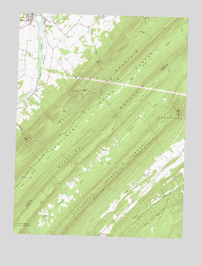
McVeytown, PA USGS Topographic Map
Click on map above to begin viewing in our Map Viewer.

This topographic map contains these locations and features:
Feature Name Type Latitude Longitude GNIS ID View Map
BlacklogPopulated PlaceN40.4240°W77.6808°1203113View Map
Blacklog MountainRangeN40.3892°W77.7422°1192155View Map
Borough of McVeytownCivilN40.4980°W77.7414°1215458View Map
Bratton GapGapN40.4295°W77.7408°1170176View Map
Byron ChurchChurchN40.3976°W77.7139°1197155View Map
Carlisle GapGapN40.4742°W77.6878°1171213View Map
Carlisle Gap TrailTrailN40.4612°W77.6839°1171214View Map
Flat TrailTrailN40.4976°W77.6497°1205694View Map
Hartzler CemeteryCemeteryN40.4976°W77.7255°1176627View Map
Hesser GapGapN40.4572°W77.7017°1176917View Map
Huffman SchoolSchoolN40.4506°W77.7408°1197153View Map
Johnson GapGapN40.4981°W77.6575°1178115View Map
KrausePopulated PlaceN40.3848°W77.7253°1178669View Map
Longfellow TrailTrailN40.4942°W77.6544°1192848View Map
MattawanaPopulated PlaceN40.4962°W77.7294°1180552View Map
Mattawana Census Designated PlaceCensusN40.4968°W77.7283°2584485View Map
Mattawana Post OfficePost OfficeN40.4959°W77.7300°2772813View Map
McVeytownPopulated PlaceN40.4992°W77.7414°1180807View Map
McVeytown AmbulanceBuildingN40.4975°W77.7403°2719629View Map
McVeytown Post OfficePost OfficeN40.4981°W77.7413°2773200View Map
McVeytown Volunteer Fire Company Station 18BuildingN40.4970°W77.7403°2645080View Map
Miller GapGapN40.4456°W77.7161°1181216View Map
Mount Pleasant CemeteryCemeteryN40.4873°W77.7150°1181803View Map
Mount Pleasant SchoolSchoolN40.3842°W77.7255°1197154View Map
Musser RunStreamN40.4915°W77.7358°1182118View Map
Peru MillsPopulated PlaceN40.3765°W77.6850°1204383View Map
Pine Glen ChurchChurchN40.4987°W77.6878°1183792View Map
Pleasant View SchoolSchoolN40.4815°W77.7205°1197152View Map
Reeds GapGapN40.4465°W77.6311°1184831View Map
Renninger GapGapN40.4904°W77.6569°1184901View Map
Spruce RunStreamN40.4956°W77.6292°1188353View Map
State Game Lands Number 215ParkN40.3951°W77.6347°1188491View Map
Sugar Springs TrailTrailN40.4204°W77.6625°1206504View Map
Township of BrattonCivilN40.4758°W77.6878°1216826View Map
Willow Run RidgeRidgeN40.3867°W77.6433°1191508View Map

Note: Coordinates in the location and feature list above are referenced to NAD83 datum.


Copyright (C) 2008-2025 Ryan Niemi / Sunset Dynamics ... All Rights Reserved