TopoQuest Logo
Do you find TopoQuest useful?
Help keep TopoQuest running and adding new maps/features by donating!
Bitcoin:  19c7KJd3qBynnjoSw5npx9KScwjBe4ifkT
Litecoin:  LXs6TkuXGGXo1vDsWCkWVdjQX94eUKd6ui
Home View Maps Find Maps Find Places Resources & Links


Melrose, Wisconsin Topographic Map

USGS Map Title: Melrose, WI
USGS Map MRC: 44090B8
DRG (GeoTIFF) Download: o44090b8.tif


Neighboring USGS Topographic Map Quads:


  Taylor, WI  
44091C1
 

  Stenulson Coulee, WI  
44090C8
 

  Black River Falls, WI  
44090C7
 

  North Bend NE, WI  
44091B1
 

  Melrose, WI  
44090B8
 

  Shamrock, WI  
44090B7
 

  North Bend, WI  
44091A1
 

  Four Corners, WI  
44090A8
 

  Cataract, WI  
44090A7


Map MRC Location:

N45°
W91°
N45°
W90°
H8 H7 H6 H5 H4 H3 H2 H1
G8 G7 G6 G5 G4 G3 G2 G1
F8 F7 F6 F5 F4 F3 F2 F1
E8 E7 E6 E5 E4 E3 E2 E1
D8 D7 D6 D5 D4 D3 D2 D1
C8 C7 C6 C5 C4 C3 C2 C1
B8 B7 B6 B5 B4 B3 B2 B1
A8 A7 A6 A5 A4 A3 A2 A1
N44°
W91°
N44°
W90°

Melrose, WI USGS 1:24K Topographic Map Preview:
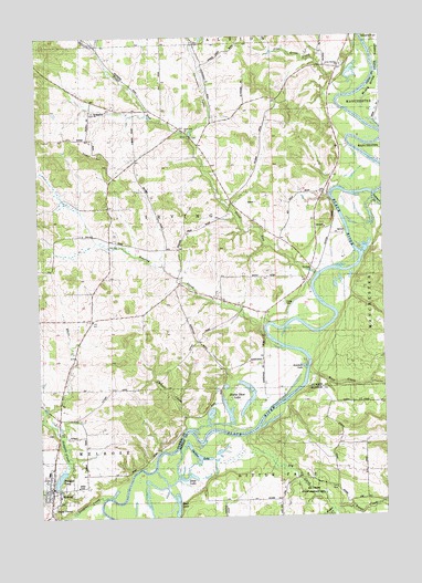
Melrose, WI USGS Topographic Map
Click on map above to begin viewing in our Map Viewer.

This topographic map contains these locations and features:
Feature Name Type Latitude Longitude GNIS ID View Map
Big CreekStreamN44.1458°W90.9254°1561699View Map
Black SloughStreamN44.1966°W90.9796°1561887View Map
Cloverdale ValleyValleyN44.2240°W90.9442°1563206View Map
Deep LakeLakeN44.1353°W90.9470°1563809View Map
Douglas CreekStreamN44.1291°W90.9779°1564081View Map
Douglas PondReservoirN44.1351°W90.9935°1564084View Map
East Branch Trout Run CreekStreamN44.2227°W90.9432°1577384View Map
Fisher CreekStreamN44.1266°W90.8943°1565011View Map
Gullickson's Glen State Natural AreaParkN44.2413°W90.9996°2062797View Map
Horse Shoe LakeLakeN44.1545°W90.9246°1566713View Map
Horswill SchoolSchoolN44.2139°W90.9346°1566751View Map
IrvingPopulated PlaceN44.1900°W90.9013°1845465View Map
Irving CemeteryCemeteryN44.1805°W90.9115°1845466View Map
Irving SchoolSchoolN44.1872°W90.9018°1566986View Map
Ketchum LakeLakeN44.1639°W90.9042°1567436View Map
Kunes CreekStreamN44.1472°W90.9479°1567660View Map
Little Norway ChurchChurchN44.2427°W90.8890°1568338View Map
MelrosePopulated PlaceN44.1305°W90.9982°1569326View Map
Melrose DamDamN44.1333°W90.9935°1791690View Map
Melrose Elementary SchoolSchoolN44.1369°W90.9975°2715782View Map
Melrose Police DepartmentBuildingN44.1307°W90.9960°2759919View Map
Melrose Volunteer Fire DepartmentBuildingN44.1306°W90.9961°2698190View Map
Mud LakeLakeN44.1283°W90.9510°1569996View Map
O'Brien SchoolSchoolN44.2302°W90.9646°1570588View Map
Pine Grove CreekStreamN44.2347°W90.8882°1571457View Map
Pine Grove SchoolSchoolN44.2416°W90.8957°1571459View Map
Pleasant Valley SchoolSchoolN44.1777°W90.9746°1571659View Map
Roaring CreekStreamN44.1716°W90.9174°1572395View Map
Roaring Creek SchoolSchoolN44.1916°W90.9490°1572396View Map
Robinson CreekStreamN44.2080°W90.8782°1572410View Map
Saint Malachys ChurchChurchN44.2305°W90.9796°1568911View Map
Shallow LakeLakeN44.1407°W90.9431°1573949View Map
Stark Valley SchoolSchoolN44.1444°W90.8921°1574814View Map
Sugar LoafSummitN44.2211°W90.9863°1575028View Map
Sugar Loaf ValleyValleyN44.2325°W90.9832°1575029View Map
Sunny Vale SchoolSchoolN44.1616°W90.9321°1575092View Map
Town of IrvingCivilN44.2025°W90.9603°1583437View Map
Trout RunStreamN44.1877°W90.8996°1575678View Map
Trout Run ChurchChurchN44.2250°W90.9465°1575679View Map
Village of MelroseCivilN44.1316°W90.9969°1583689View Map
White CreekStreamN44.1522°W90.9979°1576635View Map
Wolf CreekStreamN44.1622°W90.9032°1576932View Map

Note: Coordinates in the location and feature list above are referenced to NAD83 datum.


Copyright (C) 2008-2024 Ryan Niemi / Sunset Dynamics ... All Rights Reserved