TopoQuest Logo
Do you find TopoQuest useful?
Help keep TopoQuest running and adding new maps/features by donating!
Bitcoin:  19c7KJd3qBynnjoSw5npx9KScwjBe4ifkT
Litecoin:  LXs6TkuXGGXo1vDsWCkWVdjQX94eUKd6ui
Home View Maps Find Maps Find Places Resources & Links


Mescal Creek, California Topographic Map

USGS Map Title: Mescal Creek, CA
USGS Map MRC: 34117D6
DRG (GeoTIFF) Download: o34117d6.tif


Neighboring USGS Topographic Map Quads:


  Lovejoy Buttes, CA  
34117E7
 

  El Mirage, CA  
34117E6
 

  Shadow Mountains SE, CA  
34117E5
 

  Valyermo, CA  
34117D7
 

  Mescal Creek, CA  
34117D6
 

  Phelan, CA  
34117D5
 

  Crystal Lake, CA  
34117C7
 

  Mount San Antonio, CA  
34117C6
 

  Telegraph Peak, CA  
34117C5


Map MRC Location:

N35°
W118°
N35°
W117°
H8 H7 H6 H5 H4 H3 H2 H1
G8 G7 G6 G5 G4 G3 G2 G1
F8 F7 F6 F5 F4 F3 F2 F1
E8 E7 E6 E5 E4 E3 E2 E1
D8 D7 D6 D5 D4 D3 D2 D1
C8 C7 C6 C5 C4 C3 C2 C1
B8 B7 B6 B5 B4 B3 B2 B1
A8 A7 A6 A5 A4 A3 A2 A1
N34°
W118°
N34°
W117°

Mescal Creek, CA USGS 1:24K Topographic Map Preview:
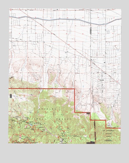
Mescal Creek, CA USGS Topographic Map
Click on map above to begin viewing in our Map Viewer.

This topographic map contains these locations and features:
Feature Name Type Latitude Longitude GNIS ID View Map
All Nations CampLocaleN34.3967°W117.7476°1655155View Map
Appletree CampgroundLocaleN34.3861°W117.7139°1669813View Map
Appletree FlatFlatN34.3878°W117.7089°269564View Map
Arch Picnic GroundLocaleN34.3800°W117.6951°275174View Map
Ball FlatFlatN34.4033°W117.7273°269653View Map
Ball Target Shooting AreaLocaleN34.3958°W117.7292°276623View Map
Big John FlatFlatN34.4172°W117.7417°269830View Map
Big PinesPopulated PlaceN34.3789°W117.6901°269839View Map
Big Pines CampLocaleN34.3956°W117.7339°1669822View Map
Big Pines Guard Station (historical)LocaleN34.3783°W117.6914°1669823View Map
Boneyard CanyonValleyN34.4375°W117.6514°269958View Map
Camp EsterLocaleN34.3889°W117.7231°276619View Map
Camp EsterLocaleN34.3897°W117.7223°275182View Map
Camp Harmony PinesLocaleN34.3892°W117.7170°275183View Map
Camp HawthorneLocaleN34.3936°W117.7212°270191View Map
Camp HemohmeLocaleN34.3892°W117.7223°270192View Map
Camp JubileeLocaleN34.4106°W117.6695°270196View Map
Camp Junipero SerraLocaleN34.3931°W117.7303°270197View Map
Camp KassabLocaleN34.3944°W117.7278°276618View Map
Camp ManzanitaLocaleN34.3944°W117.7276°270202View Map
Camp MarionLocaleN34.3761°W117.6812°270204View Map
Camp McClellanLocaleN34.3833°W117.6901°270206View Map
Camp McKiwanisLocaleN34.3894°W117.7159°270207View Map
Camp MetakaLocaleN34.3886°W117.7106°270208View Map
Camp Teresita PinesLocaleN34.3919°W117.7156°270226View Map
Camp Verdugo PinesLocaleN34.3894°W117.7264°270228View Map
Cedar CanyonValleyN34.3958°W117.7167°270357View Map
Centinela Valley CampLocaleN34.3842°W117.6981°270375View Map
Deer Ridge CampLocaleN34.3769°W117.6828°270811View Map
Graham CanyonValleyN34.4686°W117.7334°271386View Map
Grassy HollowValleyN34.3777°W117.7235°271415View Map
Grassy Hollow CampgroundLocaleN34.3764°W117.7223°276615View Map
Grassy Hollow CampgroundLocaleN34.3756°W117.7226°275175View Map
Hagenbaugh RanchLocaleN34.4361°W117.7489°271466View Map
Jackson FlatFlatN34.3811°W117.7345°271756View Map
Jackson Flat CampgroundLocaleN34.3806°W117.7370°276616View Map
Jackson Flat CampgroundLocaleN34.3808°W117.7373°275184View Map
Jackson LakeLakeN34.3922°W117.7263°271757View Map
Jesus CanyonValleyN34.4561°W117.6889°271787View Map
Kare Camp CampgroundLocaleN34.3769°W117.6834°1669867View Map
Kassab CampLocaleN34.3947°W117.7281°275181View Map
Lake CampgroundLocaleN34.3911°W117.7228°271963View Map
McClellean FlatFlatN34.3836°W117.6901°1802876View Map
Mescal CampgroundLocaleN34.3914°W117.7214°272421View Map
Mount Oak CampgroundLocaleN34.3947°W117.7301°272577View Map
Oak Spring RanchLocaleN34.3917°W117.6367°272755View Map
Peavine CampgroundLocaleN34.3883°W117.7170°272910View Map
Piņon HillsPopulated PlaceN34.4333°W117.6467°1661228View Map
Pinon Hills Elementary SchoolSchoolN34.4502°W117.6442°1841656View Map
Pinon Hills EstatesPopulated PlaceN34.4700°W117.6348°1841657View Map
Pinon Hills Post OfficePost OfficeN34.4385°W117.6423°1841659View Map
Pinon Hills Post OfficePost OfficeN34.4385°W117.6423°27833615View Map
Puzzle CanyonValleyN34.4500°W117.6748°273138View Map
San Bernardino County Fire Department Station 13 - Pinon HillsBuildingN34.4394°W117.6468°2665091View Map
Smithsonian ObservatoryLocaleN34.3819°W117.6781°273769View Map
Sunrise Ski AreaLocaleN34.3883°W117.6842°1669930View Map
Table MountainSummitN34.3829°W117.6852°274021View Map
Table Mountain CampgroundLocaleN34.3872°W117.6901°274023View Map
Twin Valley CampLocaleN34.3981°W117.7387°274255View Map
Y M C A CampLocaleN34.3964°W117.7314°274582View Map

Note: Coordinates in the location and feature list above are referenced to NAD83 datum.


Copyright (C) 2008-2024 Ryan Niemi / Sunset Dynamics ... All Rights Reserved