TopoQuest Logo
Do you find TopoQuest useful?
Help keep TopoQuest running and adding new maps/features by donating!
Bitcoin:  19c7KJd3qBynnjoSw5npx9KScwjBe4ifkT
Litecoin:  LXs6TkuXGGXo1vDsWCkWVdjQX94eUKd6ui
Home View Maps Find Maps Find Places Resources & Links


Valyermo, California Topographic Map

USGS Map Title: Valyermo, CA
USGS Map MRC: 34117D7
DRG (GeoTIFF) Download: o34117d7.tif


Neighboring USGS Topographic Map Quads:


  Littlerock, CA  
34117E8
 

  Lovejoy Buttes, CA  
34117E7
 

  El Mirage, CA  
34117E6
 

  Juniper Hills, CA  
34117D8
 

  Valyermo, CA  
34117D7
 

  Mescal Creek, CA  
34117D6
 

  Waterman Mountain, CA  
34117C8
 

  Crystal Lake, CA  
34117C7
 

  Mount San Antonio, CA  
34117C6


Map MRC Location:

N35°
W118°
N35°
W117°
H8 H7 H6 H5 H4 H3 H2 H1
G8 G7 G6 G5 G4 G3 G2 G1
F8 F7 F6 F5 F4 F3 F2 F1
E8 E7 E6 E5 E4 E3 E2 E1
D8 D7 D6 D5 D4 D3 D2 D1
C8 C7 C6 C5 C4 C3 C2 C1
B8 B7 B6 B5 B4 B3 B2 B1
A8 A7 A6 A5 A4 A3 A2 A1
N34°
W118°
N34°
W117°

Valyermo, CA USGS 1:24K Topographic Map Preview:
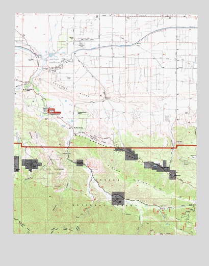
Valyermo, CA USGS Topographic Map
Click on map above to begin viewing in our Map Viewer.

This topographic map contains these locations and features:
Feature Name Type Latitude Longitude GNIS ID View Map
Big Rock CampgroundLocaleN34.3878°W117.7767°239302View Map
Big Rock CreekStreamN34.4694°W117.8584°255354View Map
Big Rock Patrol Station (historical)LocaleN34.4550°W117.8612°1669825View Map
Big Rock RanchLocaleN34.4864°W117.8351°239303View Map
Big Rock SiphonCanalN34.4778°W117.8442°239304View Map
Big Rock SpringsPopulated PlaceN34.4353°W117.8356°252854View Map
Bobs GapGapN34.4544°W117.8128°239524View Map
Boulder CanyonValleyN34.4367°W117.7509°239598View Map
Caldwell LakeLakeN34.4143°W117.7791°240001View Map
Country Mobile EstatesPopulated PlaceN34.4831°W117.8309°1733678View Map
Crystal AirportAirportN34.4857°W117.8293°1653613View Map
Crystalaire Country ClubLocaleN34.4733°W117.8476°1654605View Map
Devils ChairSummitN34.4022°W117.8456°1660547View Map
Devils PunchbowlBasinN34.4203°W117.8523°241473View Map
Devils Punchbowl County ParkParkN34.4094°W117.8476°1669846View Map
Dorr CanyonValleyN34.3933°W117.7970°241570View Map
Fenner CanyonValleyN34.3911°W117.7784°242195View Map
Grandview CanyonValleyN34.4381°W117.7684°242900View Map
Holcomb CanyonValleyN34.4158°W117.8370°243527View Map
Holcomb RidgeRidgeN34.4550°W117.8365°243528View Map
Icy SpringsSpringN34.3811°W117.7714°243766View Map
Largo VistaPopulated PlaceN34.4269°W117.7662°1660892View Map
Llano Race Track (historical)LocaleN34.4931°W117.7781°1654701View Map
Los Angeles County Camp FarmerLocaleN34.3908°W117.7723°1655113View Map
McFarland RanchLocaleN34.4119°W117.8745°245675View Map
Mile HighPopulated PlaceN34.4128°W117.7739°1661026View Map
Mile High RanchLocaleN34.4083°W117.7673°245900View Map
Mountain Brook RanchLocaleN34.4428°W117.8320°246289View Map
Old Point ComfortPopulated PlaceN34.4153°W117.8337°1661139View Map
Pallett CreekStreamN34.4617°W117.8642°247126View Map
Pallett RanchLocaleN34.4314°W117.8303°1669893View Map
Paradise SpringsPopulated PlaceN34.3958°W117.8065°1661192View Map
Pinyon RidgeRidgeN34.4058°W117.7942°247553View Map
Punchbowl CanyonValleyN34.4194°W117.8420°247823View Map
Punchbowl TrailTrailN34.4014°W117.8556°276585View Map
Saint Andrews AbbeyChurchN34.4567°W117.8684°248532View Map
Sandrock CreekStreamN34.4536°W117.8562°249010View Map
SandrocksSummitN34.4303°W117.8648°1661398View Map
Shoemaker CanyonValleyN34.4319°W117.8351°249410View Map
South Fork Big Rock CreekStreamN34.4086°W117.8228°249697View Map
South Fork CampgroundLocaleN34.3944°W117.8203°249700View Map
Sycamore Flat CampgroundLocaleN34.4131°W117.8245°250205View Map
United States Forest Service Angeles National Forest Station ValyermoBuildingN34.4447°W117.8519°276586View Map
ValyermoPopulated PlaceN34.4461°W117.8523°1661622View Map
Valyermo Post OfficePost OfficeN34.4472°W117.8540°1733695View Map
Valyermo RanchLocaleN34.4428°W117.8520°250933View Map
Valyermo Ranger StationLocaleN34.4453°W117.8523°1669936View Map

Note: Coordinates in the location and feature list above are referenced to NAD83 datum.


Copyright (C) 2008-2025 Ryan Niemi / Sunset Dynamics ... All Rights Reserved