TopoQuest Logo
Do you find TopoQuest useful?
Help keep TopoQuest running and adding new maps/features by donating!
Bitcoin:  19c7KJd3qBynnjoSw5npx9KScwjBe4ifkT
Litecoin:  LXs6TkuXGGXo1vDsWCkWVdjQX94eUKd6ui
Home View Maps Find Maps Find Places Resources & Links


Laddonia, Missouri Topographic Map

USGS Map Title: Laddonia, MO
USGS Map MRC: 39091B6
DRG (GeoTIFF) Download: o39091b6.tif


Neighboring USGS Topographic Map Quads:


  Santa Fe, MO  
39091C7
 

  Hutchison, MO  
39091C6
 

  Farber, MO  
39091C5
 

  Mexico East, MO  
39091B7
 

  Laddonia, MO  
39091B6
 

  Vandalia Lake, MO  
39091B5
 

  Mexico SE, MO  
39091A7
 

  Martinsburg, MO  
39091A6
 

  Wellsville, MO  
39091A5


Map MRC Location:

N40°
W92°
N40°
W91°
H8 H7 H6 H5 H4 H3 H2 H1
G8 G7 G6 G5 G4 G3 G2 G1
F8 F7 F6 F5 F4 F3 F2 F1
E8 E7 E6 E5 E4 E3 E2 E1
D8 D7 D6 D5 D4 D3 D2 D1
C8 C7 C6 C5 C4 C3 C2 C1
B8 B7 B6 B5 B4 B3 B2 B1
A8 A7 A6 A5 A4 A3 A2 A1
N39°
W92°
N39°
W91°

Laddonia, MO USGS 1:24K Topographic Map Preview:
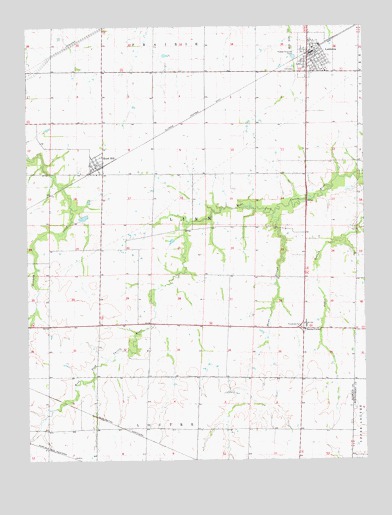
Laddonia, MO USGS Topographic Map
Click on map above to begin viewing in our Map Viewer.

This topographic map contains these locations and features:
Feature Name Type Latitude Longitude GNIS ID View Map
Boonslick Planning RegionCivilN39.1253°W91.6254°739964View Map
Cauthorn School (historical)SchoolN39.2078°W91.6510°744345View Map
City of LaddoniaCivilN39.2434°W91.6424°2395580View Map
Community R-VI Elementary SchoolSchoolN39.1645°W91.6470°2649800View Map
Community R-VI High SchoolSchoolN39.1639°W91.6470°725035View Map
Deimeke Lake DamDamN39.1750°W91.7035°765245View Map
Edwards School (historical)SchoolN39.1634°W91.6557°744350View Map
Eureka School (historical)SchoolN39.1638°W91.7240°744347View Map
Fennewald School (historical)SchoolN39.1334°W91.6682°744349View Map
Freyer Lake DamDamN39.1800°W91.6918°765244View Map
Freyer Lake East DamDamN39.1900°W91.6585°765243View Map
LaddoniaPopulated PlaceN39.2425°W91.6454°720731View Map
Laddonia Post OfficePost OfficeN39.2417°W91.6434°2782895View Map
Laddonia Rural Fire Protection AssociationBuildingN39.2436°W91.6451°2621756View Map
Mams SloughStreamN39.1964°W91.6582°721784View Map
Prairie Chapel School (historical)SchoolN39.1345°W91.7249°744348View Map
Riechers Lake DamDamN39.2117°W91.7418°765242View Map
Rush HillPopulated PlaceN39.2100°W91.7216°725673View Map
Rush Hill Post OfficePost OfficeN39.2099°W91.7245°2782941View Map
Scotts CornerPopulated PlaceN39.1628°W91.6479°741250View Map
Township of LinnCivilN39.1905°W91.6816°766242View Map
Village of Rush HillCivilN39.2102°W91.7248°2399142View Map
Walker School (historical)SchoolN39.1895°W91.7085°744346View Map

Note: Coordinates in the location and feature list above are referenced to NAD83 datum.


Copyright (C) 2008-2025 Ryan Niemi / Sunset Dynamics ... All Rights Reserved