TopoQuest Logo
Do you find TopoQuest useful?
Help keep TopoQuest running and adding new maps/features by donating!
Bitcoin:  19c7KJd3qBynnjoSw5npx9KScwjBe4ifkT
Litecoin:  LXs6TkuXGGXo1vDsWCkWVdjQX94eUKd6ui
Home View Maps Find Maps Find Places Resources & Links


Middlebourne, West Virginia Topographic Map

USGS Map Title: Middlebourne, WV
USGS Map MRC: 39080D8
DRG (GeoTIFF) Download: o39080d8.tif


Neighboring USGS Topographic Map Quads:


  New Matamoras, OH  
39081E1
 

  Paden City, WV  
39080E8
 

  Porters Falls, WV  
39080E7
 

  Bens Run, WV  
39081D1
 

  Middlebourne, WV  
39080D8
 

  Shirley, WV  
39080D7
 

  Ellenboro, WV  
39081C1
 

  Pennsboro, WV  
39080C8
 

  West Union, WV  
39080C7


Map MRC Location:

N40°
W81°
N40°
W80°
H8 H7 H6 H5 H4 H3 H2 H1
G8 G7 G6 G5 G4 G3 G2 G1
F8 F7 F6 F5 F4 F3 F2 F1
E8 E7 E6 E5 E4 E3 E2 E1
D8 D7 D6 D5 D4 D3 D2 D1
C8 C7 C6 C5 C4 C3 C2 C1
B8 B7 B6 B5 B4 B3 B2 B1
A8 A7 A6 A5 A4 A3 A2 A1
N39°
W81°
N39°
W80°

Middlebourne, WV USGS 1:24K Topographic Map Preview:
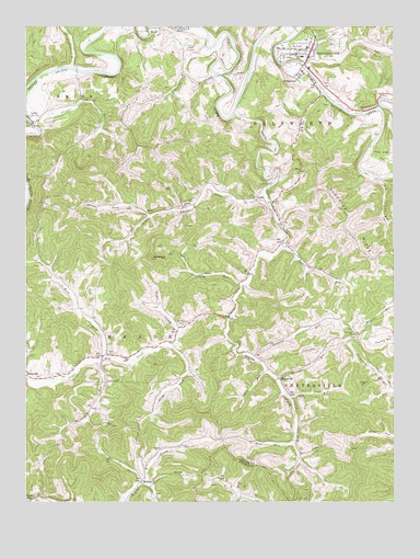
Middlebourne, WV USGS Topographic Map
Click on map above to begin viewing in our Map Viewer.

This topographic map contains these locations and features:
Feature Name Type Latitude Longitude GNIS ID View Map
Archers ChapelChurchN39.4942°W80.9454°1534999View Map
Ash ChurchChurchN39.4481°W80.9137°1535047View Map
Ash School (historical)SchoolN39.4540°W80.9154°1678610View Map
BearsvillePopulated PlaceN39.4076°W80.9137°1549582View Map
BertPopulated PlaceN39.4509°W80.9587°1549591View Map
BridgewayPopulated PlaceN39.4867°W80.9071°1553976View Map
Buffalo RunStreamN39.4892°W80.9840°1550548View Map
Cabin RunStreamN39.4090°W80.9184°1536837View Map
Davis RunStreamN39.4067°W80.9148°1538052View Map
Ellsworth Middle School (historical)SchoolN39.4967°W80.9043°1678632View Map
Fairview CemeteryCemeteryN39.4187°W80.8884°1678921View Map
Fairview ChurchChurchN39.4187°W80.8882°1538825View Map
Fairview School (historical)SchoolN39.4187°W80.8876°1678635View Map
Foster RunStreamN39.4423°W80.9129°1539169View Map
Freeland RunStreamN39.4320°W80.9262°1539247View Map
Golden Down School (historical)SchoolN39.4554°W80.9412°1678643View Map
Gorrell RunStreamN39.4942°W80.9373°1539537View Map
Gorrell RunStreamN39.4898°W80.9054°1539538View Map
Gorrell School (historical)SchoolN39.4879°W80.9457°1678645View Map
Grimms RunStreamN39.4126°W80.9223°1539755View Map
Hissom BridgeBridgeN39.4745°W80.9975°2647393View Map
Hopewell School (historical)SchoolN39.4104°W80.9443°1678647View Map
Jug RunStreamN39.4609°W80.8818°1541037View Map
Jug Run School (historical)SchoolN39.4579°W80.8776°1678653View Map
Klondike RidgeRidgeN39.4398°W80.8854°1541260View Map
Lawson ChurchChurchN39.4526°W80.9462°1541565View Map
LittlePopulated PlaceN39.4748°W80.9971°1542013View Map
Little Sancho CreekStreamN39.4562°W80.9187°1542205View Map
LockePopulated PlaceN39.4548°W80.9221°1549789View Map
McKimPopulated PlaceN39.3801°W80.9607°1549814View Map
MiddlebournePopulated PlaceN39.4923°W80.9037°1543226View Map
Middlebourne - Tyler County Volunteer Fire DepartmentBuildingN39.4929°W80.9029°2577645View Map
Middlebourne BridgeBridgeN39.4896°W80.9050°2647392View Map
Middlebourne CemeteryCemeteryN39.4981°W80.9012°1543227View Map
Middlebourne Post OfficePost OfficeN39.4929°W80.9048°1678668View Map
Mount Pleasant CemeteryCemeteryN39.4215°W80.9465°1543739View Map
Mountain View School (historical)SchoolN39.4376°W80.9626°1678673View Map
NextLocaleN39.4998°W80.9576°1544165View Map
OwlsheadSummitN39.4390°W80.9571°1544497View Map
Pleasant Dale School (historical)SchoolN39.4537°W80.9757°1678678View Map
Pyle RunStreamN39.4017°W80.9101°1545328View Map
Rock RunStreamN39.4123°W80.9998°1545930View Map
Rose RunStreamN39.3901°W80.9096°1546074View Map
Rush ForkStreamN39.4134°W80.9732°1546164View Map
Rush Fork School (historical)SchoolN39.4304°W80.9837°1678687View Map
Sancho (historical)Populated PlaceN39.4326°W80.9276°1678688View Map
Sancho CreekStreamN39.4767°W80.9298°1546336View Map
South Fork Sugar CreekStreamN39.4156°W80.9501°1547080View Map
Stewart ForkStreamN39.4506°W80.9576°1547406View Map
Stewart RunStreamN39.4737°W80.9959°1547407View Map
The JugIslandN39.4681°W80.8754°1548005View Map
Town of MiddlebourneCivilN39.4946°W80.9071°2391296View Map
Tyler CountyCivilN39.4653°W80.8848°1678706View Map
Tyler County CourthouseBuildingN39.4926°W80.9038°1678707View Map
Tyler County Emergency Medical Services Unit 1 Station 70BuildingN39.4944°W80.9021°2581097View Map
Tyler County High School (historical)SchoolN39.4923°W80.9059°1678708View Map
Tyler County Jail (historical)BuildingN39.4917°W80.9037°1678709View Map
Tyler County Public LibraryBuildingN39.4940°W80.9030°2727383View Map
Tyler County Sheriff's OfficeBuildingN39.4921°W80.9033°2727626View Map
Walnut RunStreamN39.4126°W80.9759°1548775View Map
Walnut Run School (historical)SchoolN39.3976°W80.9782°1678710View Map
WickPopulated PlaceN39.4131°W80.9740°1549119View Map
Wick Post OfficePost OfficeN39.4137°W80.9743°1678714View Map

Note: Coordinates in the location and feature list above are referenced to NAD83 datum.


Copyright (C) 2008-2025 Ryan Niemi / Sunset Dynamics ... All Rights Reserved