TopoQuest Logo
Do you find TopoQuest useful?
Help keep TopoQuest running and adding new maps/features by donating!
Bitcoin:  19c7KJd3qBynnjoSw5npx9KScwjBe4ifkT
Litecoin:  LXs6TkuXGGXo1vDsWCkWVdjQX94eUKd6ui
Home View Maps Find Maps Find Places Resources & Links


Bens Run, West Virginia Topographic Map

USGS Map Title: Bens Run, WV
USGS Map MRC: 39081D1
DRG (GeoTIFF) Download: o39081d1.tif


Neighboring USGS Topographic Map Quads:


  Rinard Mills, OH  
39081E2
 

  New Matamoras, OH  
39081E1
 

  Paden City, WV  
39080E8
 

  Raven Rock, WV  
39081D2
 

  Bens Run, WV  
39081D1
 

  Middlebourne, WV  
39080D8
 

  Schultz, WV  
39081C2
 

  Ellenboro, WV  
39081C1
 

  Pennsboro, WV  
39080C8


Map MRC Location:

N40°
W82°
N40°
W81°
H8 H7 H6 H5 H4 H3 H2 H1
G8 G7 G6 G5 G4 G3 G2 G1
F8 F7 F6 F5 F4 F3 F2 F1
E8 E7 E6 E5 E4 E3 E2 E1
D8 D7 D6 D5 D4 D3 D2 D1
C8 C7 C6 C5 C4 C3 C2 C1
B8 B7 B6 B5 B4 B3 B2 B1
A8 A7 A6 A5 A4 A3 A2 A1
N39°
W82°
N39°
W81°

Bens Run, WV USGS 1:24K Topographic Map Preview:
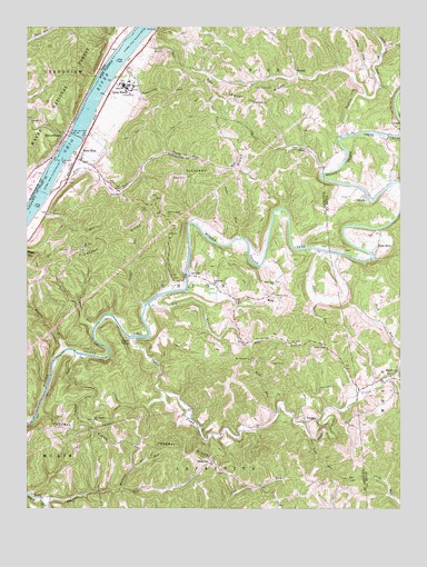
Bens Run, WV USGS Topographic Map
Click on map above to begin viewing in our Map Viewer.

This topographic map contains these locations and features:
Feature Name Type Latitude Longitude GNIS ID View Map
Algeria (historical)Populated PlaceN39.4181°W81.0526°1678485View Map
Allen RunStreamN39.4417°W81.0248°1534889View Map
ArvillaPopulated PlaceN39.4354°W81.0709°1535034View Map
BeavertownPopulated PlaceN39.4726°W81.1129°1075335View Map
Beavertown CemeteryCemeteryN39.4726°W81.1129°1963879View Map
Beech Run CemeteryCemeteryN39.4301°W81.0418°1535556View Map
Beech Run ChurchChurchN39.4337°W81.0423°1535559View Map
Bens RunPopulated PlaceN39.4659°W81.1084°1535644View Map
Bens RunStreamN39.4565°W81.1179°1535649View Map
Bens Run Post OfficePost OfficeN39.4654°W81.1059°1678614View Map
Bibbus Chapel (historical)ChurchN39.4615°W81.0754°1678492View Map
Bibbys CemeteryCemeteryN39.4615°W81.0743°1535762View Map
Big RunStreamN39.4306°W81.0798°1535934View Map
Bogart RunStreamN39.4162°W81.1123°1536187View Map
Browns School (historical)SchoolN39.4434°W81.0979°1678497View Map
Buffalo RunStreamN39.4720°W81.0176°1550549View Map
Buffalo Run School (historical)SchoolN39.4851°W81.0073°1678623View Map
Cedar RunStreamN39.4454°W81.0537°1537142View Map
Chemical Landfill DamDamN39.4801°W81.0848°1559319View Map
Cole RunStreamN39.3937°W81.0304°1537508View Map
Craig CemeteryCemeteryN39.4128°W81.0387°1537778View Map
Crooked RunStreamN39.4159°W81.1093°1537852View Map
Dawes LandingLocaleN39.4617°W81.1193°1050605View Map
District DCivilN39.4088°W81.0843°1928249View Map
Engle RunStreamN39.4526°W81.1209°1538716View Map
Engle Run School (historical)SchoolN39.4509°W81.1187°1678512View Map
EverettPopulated PlaceN39.4881°W81.0346°1554420View Map
Fairview ChurchChurchN39.4754°W81.1237°1075828View Map
Fairview Church CemeteryCemeteryN39.4756°W81.1240°1963898View Map
Falls MillsPopulated PlaceN39.4409°W81.0082°1554439View Map
Federal (historical)Populated PlaceN39.3926°W81.0868°1678514View Map
Federal RidgeRidgeN39.3926°W81.0868°1538912View Map
Hanlin SpringSpringN39.4917°W81.0846°1678162View Map
Hebron CemeteryCemeteryN39.3787°W81.1223°1678523View Map
Jackson Hall School (historical)SchoolN39.3959°W81.1148°1678529View Map
Jollys RunStreamN39.4717°W81.1115°1050606View Map
Lock and Dam Number 16DamN39.4723°W81.1098°1557858View Map
Locust Knob School (historical)SchoolN39.4084°W81.0551°1678533View Map
Long ReachChannelN39.4995°W81.0846°1060542View Map
Long ReachPopulated PlaceN39.4842°W81.0926°1549794View Map
Long Reach School (historical)SchoolN39.4815°W81.0979°1678661View Map
Lytton (historical)Populated PlaceN39.4598°W81.0779°1678534View Map
Martins RunStreamN39.3804°W81.0934°1542822View Map
Martins RunStreamN39.4751°W81.1090°1050607View Map
MeadvillePopulated PlaceN39.4087°W81.0029°1543097View Map
Momentive Performance Materials AmbulanceBuildingN39.4845°W81.0941°2581200View Map
Morris School (historical)SchoolN39.4865°W81.0462°1678670View Map
Mount Nebo CemeteryCemeteryN39.4426°W81.1057°1678541View Map
Mount Nebo ChurchChurchN39.4426°W81.1054°1543687View Map
Mount Pleasant CemeteryCemeteryN39.3984°W81.1029°1678542View Map
Mount Pleasant ChurchChurchN39.3981°W81.1026°1543748View Map
Mount Welcome ChurchChurchN39.4134°W81.0501°1543798View Map
Needmore ChurchChurchN39.4331°W81.0626°1544076View Map
Oak Grove CemeteryCemeteryN39.4840°W81.0459°1544279View Map
Oak Grove ChurchChurchN39.4806°W81.0496°1544292View Map
Oak Grove RidgeRidgeN39.4809°W81.0554°1544295View Map
Oak Grove School (historical)SchoolN39.3820°W81.0223°1678547View Map
Old Beech Run CemeteryCemeteryN39.4340°W81.0418°1678550View Map
Pleasant RidgeRidgeN39.4570°W81.0793°1545013View Map
Pleasant Ridge School (historical)SchoolN39.4623°W81.0521°1678556View Map
Point LookoutPopulated PlaceN39.4515°W81.0798°1678562View Map
Point Lookout School (historical)SchoolN39.4529°W81.0793°1678564View Map
Point Lookout United Methodist ChurchChurchN39.4517°W81.0784°1545093View Map
Rock Run School (historical)SchoolN39.4251°W81.0101°1678685View Map
Shawnee CemeteryCemeteryN39.3881°W81.0632°1678583View Map
Shawnee RunStreamN39.3759°W81.1184°1546645View Map
Shawnee Truss BridgeBridgeN39.3944°W81.0599°2647556View Map
Shawnee United Methodist ChurchChurchN39.3881°W81.0640°1678585View Map
Sheets RunStreamN39.4626°W81.0257°1546659View Map
ShilohPopulated PlaceN39.4562°W81.0115°1555612View Map
Shiloh BridgeBridgeN39.4564°W81.0107°2647394View Map
Stouts RunStreamN39.4217°W81.1026°1547521View Map
Sugar CreekStreamN39.4195°W81.0907°1547633View Map
Sugar ValleyPopulated PlaceN39.4195°W81.0871°1555736View Map
Sugar Valley School (historical)SchoolN39.4117°W81.0312°1678591View Map
Sugarcamp RunStreamN39.4870°W81.0959°1547689View Map
Tackets RunStreamN39.4279°W81.0857°1547862View Map
TwiggsPopulated PlaceN39.3976°W81.0318°1555844View Map
Union ChapelChurchN39.4176°W81.0251°1548473View Map
Union Chapel CemeteryCemeteryN39.4176°W81.0254°1678593View Map
Walnut Hill School (historical)SchoolN39.4337°W81.1187°1678596View Map
WaspPopulated PlaceN39.4301°W81.0440°1555924View Map
Wasp School (historical)SchoolN39.4304°W81.0432°1678599View Map
Wells RunStreamN39.4973°W81.0848°1548906View Map
Wolf RunStreamN39.3998°W81.0409°1549294View Map

Note: Coordinates in the location and feature list above are referenced to NAD83 datum.


Copyright (C) 2008-2025 Ryan Niemi / Sunset Dynamics ... All Rights Reserved