TopoQuest Logo
Do you find TopoQuest useful?
Help keep TopoQuest running and adding new maps/features by donating!
Bitcoin:  19c7KJd3qBynnjoSw5npx9KScwjBe4ifkT
Litecoin:  LXs6TkuXGGXo1vDsWCkWVdjQX94eUKd6ui
Home View Maps Find Maps Find Places Resources & Links


Pennsboro, West Virginia Topographic Map

USGS Map Title: Pennsboro, WV
USGS Map MRC: 39080C8
DRG (GeoTIFF) Download: o39080c8.tif


Neighboring USGS Topographic Map Quads:


  Bens Run, WV  
39081D1
 

  Middlebourne, WV  
39080D8
 

  Shirley, WV  
39080D7
 

  Ellenboro, WV  
39081C1
 

  Pennsboro, WV  
39080C8
 

  West Union, WV  
39080C7
 

  Harrisville, WV  
39081B1
 

  Pullman, WV  
39080B8
 

  Oxford, WV  
39080B7


Map MRC Location:

N40°
W81°
N40°
W80°
H8 H7 H6 H5 H4 H3 H2 H1
G8 G7 G6 G5 G4 G3 G2 G1
F8 F7 F6 F5 F4 F3 F2 F1
E8 E7 E6 E5 E4 E3 E2 E1
D8 D7 D6 D5 D4 D3 D2 D1
C8 C7 C6 C5 C4 C3 C2 C1
B8 B7 B6 B5 B4 B3 B2 B1
A8 A7 A6 A5 A4 A3 A2 A1
N39°
W81°
N39°
W80°

Pennsboro, WV USGS 1:24K Topographic Map Preview:
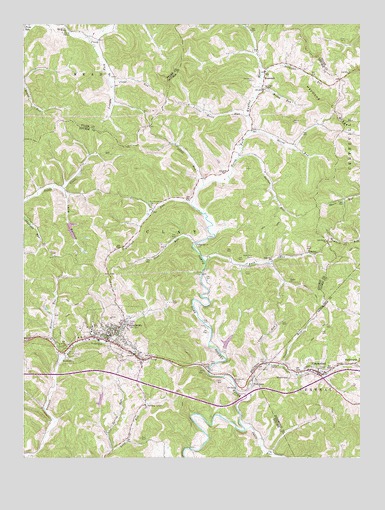
Pennsboro, WV USGS Topographic Map
Click on map above to begin viewing in our Map Viewer.

This topographic map contains these locations and features:
Feature Name Type Latitude Longitude GNIS ID View Map
Bonds Creek Structure One DamDamN39.3184°W80.9832°1559289View Map
Broadwater CemeteryCemeteryN39.2715°W80.9207°1536378View Map
Brush RunStreamN39.3565°W80.9118°1536476View Map
Buck RunStreamN39.3062°W80.9326°1536572View Map
Buck Run CemeteryCemeteryN39.3079°W80.9151°1536577View Map
Buck Run School (historical)SchoolN39.3087°W80.8921°1536578View Map
Bunnell Run School (historical)SchoolN39.2601°W80.9904°1688932View Map
Burnthouse CemeteryCemeteryN39.3228°W80.9527°1536770View Map
Burton RunStreamN39.3359°W80.9204°1536775View Map
Cabin RunStreamN39.2579°W80.9179°1536838View Map
Charleys RunStreamN39.3195°W80.9998°1537220View Map
Chestnut Grove School (historical)SchoolN39.2995°W80.9304°1688941View Map
City of PennsboroCivilN39.2835°W80.9662°2390634View Map
Clay DistrictCivilN39.2875°W80.9800°1928193View Map
Cline RunStreamN39.3584°W80.9679°1537415View Map
Creed Collins Elementary SchoolSchoolN39.2861°W80.9720°1688950View Map
Dotson RunStreamN39.2684°W80.9179°1538284View Map
DuckworthPopulated PlaceN39.2773°W80.8762°1554332View Map
Gnat RunStreamN39.3117°W80.9365°1539478View Map
Gnat Run ChurchChurchN39.3115°W80.9354°1539479View Map
GreenwoodPopulated PlaceN39.2748°W80.8907°1554612View Map
Greenwood CemeteryCemeteryN39.2759°W80.8879°1689490View Map
Greenwood Post OfficePost OfficeN39.2581°W80.8907°1689491View Map
Greenwood Volunteer Fire DepartmentBuildingN39.2746°W80.8880°2577892View Map
Horner RunStreamN39.2781°W80.9865°1540470View Map
Joseph School (historical)SchoolN39.3601°W80.9659°1678652View Map
Josephs ForkStreamN39.3712°W80.9757°1541026View Map
Lizzies Roost RunStreamN39.3487°W80.9165°1542277View Map
Long BottomValleyN39.3273°W80.9851°1542333View Map
Long RunStreamN39.2523°W80.9676°1542408View Map
Marsh RunStreamN39.3440°W80.9154°1542792View Map
Masonic CemeteryCemeteryN39.2798°W80.9804°1542851View Map
Mole Hill ChapelChurchN39.3562°W80.9101°1543484View Map
Mount Vernon School (historical)SchoolN39.3390°W80.8968°1689016View Map
MountainPopulated PlaceN39.3620°W80.9104°1543852View Map
Mountain CemeteryCemeteryN39.3587°W80.9148°1543853View Map
Mountain Post OfficePost OfficeN39.3556°W80.9109°1689017View Map
Oak Grove ChurchChurchN39.3123°W80.8873°1544290View Map
PennsboroPopulated PlaceN39.2851°W80.9684°1544704View Map
Pennsboro Police DepartmentBuildingN39.2853°W80.9680°2728168View Map
Pennsboro Post OfficePost OfficeN39.2847°W80.9701°1689029View Map
Pennsboro Public LibraryBuildingN39.2851°W80.9677°2727377View Map
Pennsboro Volunteer Fire DepartmentBuildingN39.2849°W80.9692°2577859View Map
Pennsboro Water Supply LakeReservoirN39.2833°W80.9247°1559294View Map
Plum Road School (historical)SchoolN39.3748°W80.9993°1678680View Map
Plum RunStreamN39.3742°W80.9976°1545067View Map
Plum RunPopulated PlaceN39.3748°W80.9996°1555378View Map
Poplar ChurchChurchN39.3006°W80.9012°1545139View Map
Poplarlick RunStreamN39.3229°W80.9376°1545154View Map
Reservoir Run DamDamN39.2817°W80.9248°1559293View Map
Ritchie County Ambulance Authority Station 41BuildingN39.2846°W80.9742°2581105View Map
StanleyPopulated PlaceN39.3087°W80.8921°1555701View Map
Straight RunStreamN39.3604°W80.9115°1547576View Map
Sugar RunStreamN39.2770°W80.9109°1547647View Map
Sunshine School (historical)SchoolN39.3167°W80.8848°1678704View Map
Taylor School (historical)SchoolN39.2548°W80.9482°1689069View Map
Toll GatePopulated PlaceN39.2726°W80.9151°1555815View Map
Toll Gate Post OfficePost OfficeN39.2731°W80.9143°1689073View Map
Xddox RunStreamN39.3284°W80.9329°1549444View Map
Yeager RunStreamN39.2765°W80.9040°1549451View Map

Note: Coordinates in the location and feature list above are referenced to NAD83 datum.


Copyright (C) 2008-2025 Ryan Niemi / Sunset Dynamics ... All Rights Reserved