TopoQuest Logo
Do you find TopoQuest useful?
Help keep TopoQuest running and adding new maps/features by donating!
Bitcoin:  19c7KJd3qBynnjoSw5npx9KScwjBe4ifkT
Litecoin:  LXs6TkuXGGXo1vDsWCkWVdjQX94eUKd6ui
Home View Maps Find Maps Find Places Resources & Links


New Matamoras, Ohio Topographic Map

USGS Map Title: New Matamoras, OH
USGS Map MRC: 39081E1
DRG (GeoTIFF) Download: o39081e1.tif


Neighboring USGS Topographic Map Quads:


  Graysville, OH  
39081F2
 

  Antioch, OH  
39081F1
 

  Round Bottom, OH  
39080F8
 

  Rinard Mills, OH  
39081E2
 

  New Matamoras, OH  
39081E1
 

  Paden City, WV  
39080E8
 

  Raven Rock, WV  
39081D2
 

  Bens Run, WV  
39081D1
 

  Middlebourne, WV  
39080D8


Map MRC Location:

N40°
W82°
N40°
W81°
H8 H7 H6 H5 H4 H3 H2 H1
G8 G7 G6 G5 G4 G3 G2 G1
F8 F7 F6 F5 F4 F3 F2 F1
E8 E7 E6 E5 E4 E3 E2 E1
D8 D7 D6 D5 D4 D3 D2 D1
C8 C7 C6 C5 C4 C3 C2 C1
B8 B7 B6 B5 B4 B3 B2 B1
A8 A7 A6 A5 A4 A3 A2 A1
N39°
W82°
N39°
W81°

New Matamoras, OH USGS 1:24K Topographic Map Preview:
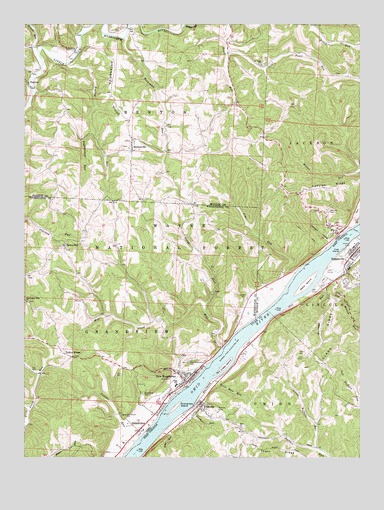
New Matamoras, OH USGS Topographic Map
Click on map above to begin viewing in our Map Viewer.

This topographic map contains these locations and features:
Feature Name Type Latitude Longitude GNIS ID View Map
Biglick RunStreamN39.6134°W81.1084°1075384View Map
Bradfield LandingLocaleN39.5437°W81.0334°1051033View Map
Browns RunStreamN39.6165°W81.1190°1075452View Map
BrownsvillePopulated PlaceN39.5890°W81.0843°1075453View Map
Brownsville Methodist CemeteryCemeteryN39.5884°W81.0837°1963751View Map
Brownsville Methodist ChurchChurchN39.5884°W81.0840°1963752View Map
Brownsville United Presbyterian CemeteryCemeteryN39.5900°W81.0867°2073976View Map
Carson CemeteryCemeteryN39.5467°W81.0420°1963886View Map
Centerview (historical)Populated PlaceN39.5445°W81.0346°1065546View Map
Central DistrictCivilN39.5003°W81.0388°1928187View Map
City of MatamorasCivilN39.5237°W81.0621°1085662View Map
Clark RidgeRidgeN39.5342°W81.0071°1550716View Map
Collins RunStreamN39.5045°W81.0837°1075611View Map
Cow Hollow RunStreamN39.5573°W81.0096°1550809View Map
Crab IslandIslandN39.5598°W81.0071°1550814View Map
Devil Hole RunStreamN39.5226°W81.0554°1550910View Map
Excelsior School (historical)SchoolN39.5148°W81.0209°1678633View Map
First Christian ChurchChurchN39.5601°W81.0026°1678637View Map
FlyPopulated PlaceN39.5648°W81.0084°1075863View Map
Fly FerryCrossingN39.5654°W81.0018°1051035View Map
Fly Post OfficePost OfficeN39.5654°W81.0082°2037305View Map
FriendlyPopulated PlaceN39.5159°W81.0593°1554513View Map
Friendly CemeteryCemeteryN39.5134°W81.0537°1551183View Map
Friendly Post OfficePost OfficeN39.5146°W81.0614°1678641View Map
Frontier High SchoolSchoolN39.5212°W81.0682°1071056View Map
German Lutheran CemeteryCemeteryN39.5911°W81.0858°2073978View Map
GrandviewPopulated PlaceN39.5081°W81.0821°1075947View Map
Grandview CemeteryCemeteryN39.5187°W81.0807°1075948View Map
Grandview IslandIslandN39.5145°W81.0684°1551266View Map
Grandview RunStreamN39.5062°W81.0848°1050688View Map
Grandview Township Volunteer Fire DepartmentBuildingN39.5223°W81.0650°2549804View Map
Greenbrier RidgeRidgeN39.6045°W81.0926°1075961View Map
Hensel CemeteryCemeteryN39.5919°W81.0867°2073979View Map
JerichoPopulated PlaceN39.6176°W81.1062°1076142View Map
Jericho Methodist CemeteryCemeteryN39.6151°W81.1087°1963767View Map
Jericho Methodist ChurchChurchN39.6156°W81.1082°1963768View Map
Jims RunStreamN39.5492°W81.0273°1076144View Map
Johnson HollowValleyN39.5626°W81.0118°1076153View Map
Little Buffalo RunStreamN39.5026°W81.0162°1551842View Map
Little Trail RunStreamN39.6170°W81.0487°1076282View Map
Ludolph RidgeRidgeN39.5779°W81.0096°1077283View Map
Matamoras Elementary SchoolSchoolN39.5206°W81.0684°1050689View Map
Mehrley CemeteryCemeteryN39.5709°W81.0115°1076374View Map
Mill CreekStreamN39.5320°W81.0515°1076390View Map
Mill Creek IslandIslandN39.5265°W81.0501°1552106View Map
Mill Creek LandingLocaleN39.5309°W81.0521°1050690View Map
Miller RunStreamN39.5676°W81.0007°1076396View Map
Narrows RunStreamN39.5467°W81.0215°1552275View Map
New MatamorasPopulated PlaceN39.5245°W81.0671°1085479View Map
New Matamoras CemeteryCemeteryN39.5287°W81.0615°1077277View Map
New Matamoras Emergency Medical ServicesBuildingN39.5225°W81.0650°2550707View Map
North Fork Mill CreekStreamN39.5442°W81.0565°1076526View Map
Parker RunStreamN39.5129°W81.0659°1552434View Map
Pigeonroost RunStreamN39.5931°W81.0996°1076629View Map
PoultonPopulated PlaceN39.6076°W81.1212°1076684View Map
Poulton Post Office (historical)Post OfficeN39.6070°W81.1207°2037371View Map
Rings Mills CemeteryCemeteryN39.6117°W81.1212°1963793View Map
Rockcamp RunStreamN39.6212°W81.0873°1077276View Map
Rockcamp RunStreamN39.6215°W81.0871°1060554View Map
Saint Pauls Evangelical CemeteryCemeteryN39.6145°W81.0359°1963798View Map
Saint Pauls United Church of ChristChurchN39.6134°W81.0359°1076803View Map
Salem HallLocaleN39.5612°W81.1090°1076810View Map
Salem Hall CemeteryCemeteryN39.5603°W81.1096°1963936View Map
Sistersville Country Club Golf CourseLocaleN39.5533°W81.0110°2634190View Map
Sistersville General HospitalHospitalN39.5588°W81.0041°1678695View Map
Sistersville General Hospital Ambulance ServiceBuildingN39.5587°W81.0013°2581147View Map
Sistersville High School (historical)SchoolN39.5609°W81.0021°1678696View Map
Sistersville Junior High School (historical)SchoolN39.5606°W81.0023°1678698View Map
Sistersville Volunteer Fire DepartmentBuildingN39.5569°W81.0039°2577846View Map
Springer GraveCemeteryN39.5453°W81.1059°1963939View Map
Stringtown (historical)Populated PlaceN39.5606°W81.0140°1051034View Map
Tanyard RunStreamN39.5637°W81.0018°1553177View Map
Thorn RidgeRidgeN39.5031°W81.0304°1553219View Map
Town of FriendlyCivilN39.5136°W81.0618°2390192View Map
Township of BentonCivilN39.6031°W81.0879°1086647View Map
Township of GrandviewCivilN39.5242°W81.1085°1087133View Map
Township of JacksonCivilN39.6035°W81.0007°1086652View Map
Trail Run (historical)Populated PlaceN39.6167°W81.0490°1051032View Map
Village of MatamorasCivilN39.5203°W81.0685°2399272View Map
WahanakerPopulated PlaceN39.5901°W81.0582°1068266View Map
Washington Hall ChurchChurchN39.5448°W81.1237°1077141View Map
Wells IslandIslandN39.5504°W81.0196°1553403View Map
Witten ForkStreamN39.6248°W81.0640°1077216View Map
Yellow HouseLocaleN39.5290°W81.1073°1077243View Map
Yoho RunStreamN39.5087°W81.0718°1553537View Map
Zion ChurchChurchN39.5090°W81.0443°1553546View Map

Note: Coordinates in the location and feature list above are referenced to NAD83 datum.


Copyright (C) 2008-2025 Ryan Niemi / Sunset Dynamics ... All Rights Reserved