TopoQuest Logo
Do you find TopoQuest useful?
Help keep TopoQuest running and adding new maps/features by donating!
Bitcoin:  19c7KJd3qBynnjoSw5npx9KScwjBe4ifkT
Litecoin:  LXs6TkuXGGXo1vDsWCkWVdjQX94eUKd6ui
Home View Maps Find Maps Find Places Resources & Links


Milam, West Virginia Topographic Map

USGS Map Title: Milam, WV
USGS Map MRC: 38079G1
DRG (GeoTIFF) Download: o38079g1.tif


Neighboring USGS Topographic Map Quads:


  Petersburg West, WV  
38079H2
 

  Petersburg East, WV  
38079H1
 

  Lost River State Park, WV  
38078H8
 

  Mozer, WV  
38079G2
 

  Milam, WV  
38079G1
 

  Bergton, VA  
38078G8
 

  Fort Seybert, WV  
38079F2
 

  Cow Knob, VA  
38079F1
 

  Fulks Run, VA  
38078F8


Map MRC Location:

N39°
W80°
N39°
W79°
H8 H7 H6 H5 H4 H3 H2 H1
G8 G7 G6 G5 G4 G3 G2 G1
F8 F7 F6 F5 F4 F3 F2 F1
E8 E7 E6 E5 E4 E3 E2 E1
D8 D7 D6 D5 D4 D3 D2 D1
C8 C7 C6 C5 C4 C3 C2 C1
B8 B7 B6 B5 B4 B3 B2 B1
A8 A7 A6 A5 A4 A3 A2 A1
N38°
W80°
N38°
W79°

Milam, WV USGS 1:24K Topographic Map Preview:
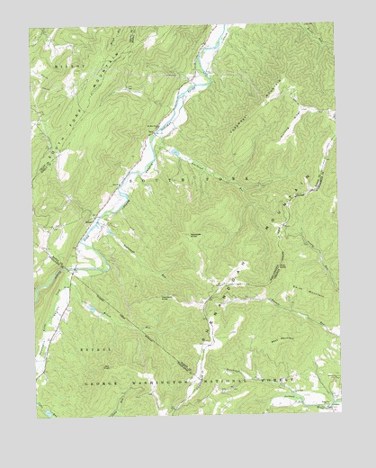
Milam, WV USGS Topographic Map
Click on map above to begin viewing in our Map Viewer.

This topographic map contains these locations and features:
Feature Name Type Latitude Longitude GNIS ID View Map
Ant KnobSummitN38.7659°W79.0942°1550108View Map
Bergdoll School (historical)SchoolN38.8718°W79.1164°1556994View Map
Clover Hill Volunteer Fire Company and Rescue 17BuildingN38.7764°W79.0461°2086016View Map
CridersPopulated PlaceN38.7515°W79.0042°1495441View Map
Criders ChurchChurchN38.7615°W79.0017°1482834View Map
Criders Post OfficePost OfficeN38.7522°W79.0059°2766450View Map
Criders School (historical)SchoolN38.8082°W79.0220°1806023View Map
Criders School (historical)SchoolN38.8468°W79.0025°1556831View Map
Damascus ChurchChurchN38.7526°W79.0067°1482905View Map
Deep Spring School (historical)SchoolN38.8407°W79.1206°1556999View Map
Foremost MountainSummitN38.8457°W79.0356°1551153View Map
Haystack KnobSummitN38.7882°W79.0736°1551398View Map
Hinkle School (historical)SchoolN38.8093°W79.1175°1556845View Map
Hunting RidgeRidgeN38.8434°W79.0175°1551530View Map
Hupp School (historical)SchoolN38.7615°W79.0389°1806026View Map
Kettle CreekStreamN38.7973°W79.1098°1551643View Map
Mays MountainSummitN38.7723°W79.0261°1485246View Map
MilamPopulated PlaceN38.8140°W79.0992°1552093View Map
Milam Post OfficePost OfficeN38.8193°W79.0939°1718569View Map
Mount Hope School (historical)SchoolN38.7523°W79.0684°1677608View Map
Mount Olive ChurchChurchN38.8429°W79.0731°1552211View Map
Mount Pleasant School (historical)SchoolN38.7876°W79.0525°1806028View Map
Nettie Davis SpringSpringN38.8132°W79.1234°1678106View Map
Persimmon RunStreamN38.7565°W79.0200°1486156View Map
PeruPopulated PlaceN38.8409°W79.0742°1552459View Map
Pine KnobSummitN38.7968°W79.0242°1496088View Map
Reynolds KnobSummitN38.8079°W79.0625°1552639View Map
Rodabaugh RunStreamN38.8126°W79.0978°1552723View Map
Rohrbaugh RunStreamN38.8418°W79.0717°1552725View Map
Shenandoah MountainRangeN38.7690°W79.0559°1487178View Map
Smith MountainSummitN38.7871°W79.0120°1496237View Map
Smith School (historical)SchoolN38.7748°W79.0003°1805809View Map
South Fork Structure 37 DamDamN38.7518°W79.1198°1559214View Map
South Fork Structure Five DamDamN38.8101°W79.0931°1558882View Map
South Fork Structure Four DamDamN38.8351°W79.0664°1558881View Map
South Fork Structure Six DamDamN38.7851°W79.1014°1559198View Map
Sweedlin ValleyValleyN38.7968°W79.1100°1553160View Map
Sweedlin Valley School (historical)SchoolN38.7648°W79.1220°1677616View Map
Trumbo Ford BridgeBridgeN38.7977°W79.1079°2646966View Map
Valley View ChurchChurchN38.7571°W79.0192°1488101View Map
Wilson RunStreamN38.7940°W79.1120°1553483View Map
Wine Spring School (historical)SchoolN38.8137°W79.0992°1556881View Map
Zion ChurchChurchN38.8243°W79.0892°1553545View Map

Note: Coordinates in the location and feature list above are referenced to NAD83 datum.


Copyright (C) 2008-2024 Ryan Niemi / Sunset Dynamics ... All Rights Reserved