TopoQuest Logo
Do you find TopoQuest useful?
Help keep TopoQuest running and adding new maps/features by donating!
Bitcoin:  19c7KJd3qBynnjoSw5npx9KScwjBe4ifkT
Litecoin:  LXs6TkuXGGXo1vDsWCkWVdjQX94eUKd6ui
Home View Maps Find Maps Find Places Resources & Links


Millersburg, Ohio Topographic Map

USGS Map Title: Millersburg, OH
USGS Map MRC: 40081E8
DRG (GeoTIFF) Download: o40081e8.tif


Neighboring USGS Topographic Map Quads:


  Shreve, OH  
40082F1
 

  Holmesville, OH  
40081F8
 

  Fredericksburg, OH  
40081F7
 

  Glenmont, OH  
40082E1
 

  Millersburg, OH  
40081E8
 

  Berlin, OH  
40081E7
 

  Spring Mountain, OH  
40082D1
 

  Killbuck, OH  
40081D8
 

  New Bedford, OH  
40081D7


Map MRC Location:

N41°
W82°
N41°
W81°
H8 H7 H6 H5 H4 H3 H2 H1
G8 G7 G6 G5 G4 G3 G2 G1
F8 F7 F6 F5 F4 F3 F2 F1
E8 E7 E6 E5 E4 E3 E2 E1
D8 D7 D6 D5 D4 D3 D2 D1
C8 C7 C6 C5 C4 C3 C2 C1
B8 B7 B6 B5 B4 B3 B2 B1
A8 A7 A6 A5 A4 A3 A2 A1
N40°
W82°
N40°
W81°

Millersburg, OH USGS 1:24K Topographic Map Preview:
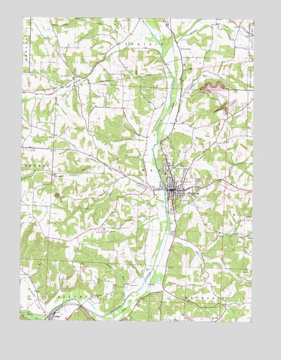
Millersburg, OH USGS Topographic Map
Click on map above to begin viewing in our Map Viewer.

This topographic map contains these locations and features:
Feature Name Type Latitude Longitude GNIS ID View Map
Bear RunStreamN40.5642°W81.9557°1037728View Map
Briar Hill Airport (historical)AirportN40.5398°W81.9182°1074893View Map
Briar Hill Golf CourseLocaleN40.5542°W81.9013°1056040View Map
Christy Chapel CemeteryCemeteryN40.5423°W81.9938°1961574View Map
Church of Christ (historical)ChurchN40.5556°W81.9004°1079886View Map
Clover PatchLocaleN40.5494°W81.9864°2628461View Map
Clover Patch DairyLocaleN40.5492°W81.9867°2706141View Map
Coffee RunStreamN40.6181°W81.9304°1037279View Map
Colliers RunStreamN40.5920°W81.9201°1039256View Map
Corns RunStreamN40.5595°W81.9468°1039379View Map
First Presbyterian ChurchChurchN40.5531°W81.9176°1079887View Map
Gambles School (historical)SchoolN40.5795°W81.9643°1053496View Map
Gindlesberger CemeteryCemeteryN40.5885°W81.8780°1961587View Map
Gorrell CemeteryCemeteryN40.6213°W81.9839°1040974View Map
Grade (historical)Populated PlaceN40.5076°W81.8885°1053489View Map
Grade Post Office (historical)Post OfficeN40.5070°W81.8888°2013568View Map
Gray Ridge ChurchChurchN40.5006°W81.8960°1041087View Map
Gray Ridge School (historical)SchoolN40.5006°W81.9110°1053490View Map
Hammond School (historical)SchoolN40.6103°W81.9001°1053485View Map
Hardy Junction (historical)LocaleN40.5076°W81.9385°1053491View Map
Hardy RunStreamN40.5084°W81.9438°1041318View Map
Hayes School (historical)SchoolN40.6087°W81.9485°1053494View Map
Holmes CountyCivilN40.5612°W81.9294°1074050View Map
Holmes County AirportAirportN40.5379°W81.9563°1082863View Map
Holmes County CourthouseBuildingN40.5537°W81.9170°1077448View Map
Holmes County District Public LibraryBuildingN40.5545°W81.9182°1079901View Map
Holmes County HomeBuildingN40.6126°W81.9140°1079984View Map
Holmes County LandfillLocaleN40.5953°W81.8950°2677743View Map
Holmes County LandfillLocaleN40.5953°W81.8961°2678517View Map
Holmes County Law LibraryBuildingN40.5540°W81.9165°1963965View Map
Holmes County Sheriff's OfficeBuildingN40.6101°W81.9112°2733054View Map
Holmes Fire and Emergency Medical Services District 1BuildingN40.5540°W81.9284°2550261View Map
Honey RunStreamN40.5806°W81.9260°1041741View Map
Honey Run School (historical)SchoolN40.5812°W81.9093°1053486View Map
Huston (historical)Populated PlaceN40.6078°W81.9176°1067409View Map
Lauther School (historical)SchoolN40.5437°W81.9326°1053492View Map
Locust Grove ChurchChurchN40.5103°W81.9615°1042710View Map
Martins CreekStreamN40.6090°W81.9249°1066091View Map
Millerburg Police DepartmentBuildingN40.5544°W81.9187°2732820View Map
MillersburgPopulated PlaceN40.5545°W81.9179°1057849View Map
Millersburg City HallBuildingN40.5545°W81.9160°1079889View Map
Millersburg Elementary SchoolSchoolN40.5545°W81.9118°1056065View Map
Millersburg High School (historical)SchoolN40.5548°W81.9118°1079890View Map
Millersburg Historic DistrictParkN40.5542°W81.9179°1071600View Map
Millersburg Post OfficePost OfficeN40.5534°W81.9188°1083495View Map
Millersburg Post OfficePost OfficeN40.5542°W81.9179°2013553View Map
Millersburg United Methodist ChurchChurchN40.5562°W81.9190°1080017View Map
Millersburg WaterworksLocaleN40.5556°W81.9232°1079891View Map
Monroe Lutheran CemeteryCemeteryN40.5487°W81.9932°1961602View Map
Oak Grove CemeteryCemeteryN40.5514°W81.9110°1044029View Map
Oak Ridge School (historical)SchoolN40.5770°W81.9363°1053493View Map
Paint CreekStreamN40.6181°W81.9307°1044277View Map
Pomerene HospitalHospitalN40.5652°W81.9203°1079888View Map
Saint Johns Evangelical ChurchChurchN40.5545°W81.9140°1079892View Map
Saint Peters Roman Catholic ChurchChurchN40.5506°W81.9151°1079893View Map
Sand RunStreamN40.5340°W81.9235°1045939View Map
Sand Run HillSummitN40.5165°W81.8976°1065868View Map
Sand Run School (historical)SchoolN40.5281°W81.9065°1053488View Map
Sapps RunStreamN40.5492°W81.9224°1066188View Map
Shrimplin CemeteryCemeteryN40.5085°W81.9952°1961622View Map
Shrimplin CreekStreamN40.5028°W81.9838°1066201View Map
Township of HardyCivilN40.5595°W81.9211°1086329View Map
Trinity Lutheran ChurchChurchN40.5523°W81.9171°1079894View Map
Uhl CemeteryCemeteryN40.5303°W81.9339°1961626View Map
Uhl RunStreamN40.5598°W81.9468°1047260View Map
Union School (historical)SchoolN40.6170°W81.9815°1053495View Map
Upper Honey Run School (historical)SchoolN40.5767°W81.8782°1053487View Map
Upper Sand RunStreamN40.5367°W81.8846°1047374View Map
Village of MillersburgCivilN40.5534°W81.9170°2399357View Map

Note: Coordinates in the location and feature list above are referenced to NAD83 datum.


Copyright (C) 2008-2024 Ryan Niemi / Sunset Dynamics ... All Rights Reserved