TopoQuest Logo
Do you find TopoQuest useful?
Help keep TopoQuest running and adding new maps/features by donating!
Bitcoin:  19c7KJd3qBynnjoSw5npx9KScwjBe4ifkT
Litecoin:  LXs6TkuXGGXo1vDsWCkWVdjQX94eUKd6ui
Home View Maps Find Maps Find Places Resources & Links


Millerstown, Pennsylvania Topographic Map

USGS Map Title: Millerstown, PA
USGS Map MRC: 40077E2
DRG (GeoTIFF) Download: o40077e2.tif


Neighboring USGS Topographic Map Quads:


  McClure, PA  
40077F3
 

  Beaver Springs, PA  
40077F2
 

  Richfield, PA  
40077F1
 

  Mexico, PA  
40077E3
 

  Millerstown, PA  
40077E2
 

  Reward, PA  
40077E1
 

  Ickesburg, PA  
40077D3
 

  Newport, PA  
40077D2
 

  Duncannon, PA  
40077D1


Map MRC Location:

N41°
W78°
N41°
W77°
H8 H7 H6 H5 H4 H3 H2 H1
G8 G7 G6 G5 G4 G3 G2 G1
F8 F7 F6 F5 F4 F3 F2 F1
E8 E7 E6 E5 E4 E3 E2 E1
D8 D7 D6 D5 D4 D3 D2 D1
C8 C7 C6 C5 C4 C3 C2 C1
B8 B7 B6 B5 B4 B3 B2 B1
A8 A7 A6 A5 A4 A3 A2 A1
N40°
W78°
N40°
W77°

Millerstown, PA USGS 1:24K Topographic Map Preview:
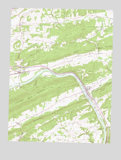
Millerstown, PA USGS Topographic Map
Click on map above to begin viewing in our Map Viewer.

This topographic map contains these locations and features:
Feature Name Type Latitude Longitude GNIS ID View Map
Auker CemeteryCemeteryN40.5815°W77.1655°1168511View Map
Bethlehem ChurchChurchN40.6167°W77.1264°1169432View Map
Borough of MillerstownCivilN40.5543°W77.1530°1215528View Map
Borough of ThompsontownCivilN40.5658°W77.2361°1215312View Map
Buckwheat RunStreamN40.5167°W77.2342°1170589View Map
Bull Hill CemeteryCemeteryN40.5226°W77.2433°1170640View Map
Cabala RunStreamN40.6115°W77.1275°1170849View Map
Cocolamus CreekStreamN40.5365°W77.1469°1172118View Map
Cranes RunStreamN40.5915°W77.1447°1172644View Map
Deardorff CemeteryCemeteryN40.5154°W77.1394°1173036View Map
Delaware ChurchChurchN40.6015°W77.2358°1173123View Map
Delaware CreekStreamN40.5548°W77.2336°1173124View Map
Delaware Township Volunteer Fire Company Station 6BuildingN40.6080°W77.2368°2645237View Map
Dewey HillSummitN40.5884°W77.2164°1202336View Map
DimmsvillePopulated PlaceN40.6059°W77.1361°1173282View Map
Donnally MillsPopulated PlaceN40.5170°W77.2369°1173379View Map
Durward StationLocaleN40.5612°W77.2069°1173646View Map
Dutchman RunStreamN40.5973°W77.1550°1173664View Map
East SalemPopulated PlaceN40.6090°W77.2380°1173867View Map
East Salem Census Designated PlaceCensusN40.6087°W77.2369°2584453View Map
Evans HollowValleyN40.5767°W77.2332°1174348View Map
GoodvillePopulated PlaceN40.5926°W77.2003°1175819View Map
GramerePopulated PlaceN40.5242°W77.2189°1212871View Map
Hominy RidgeRidgeN40.5140°W77.1953°1177336View Map
Kramer RunStreamN40.5320°W77.1911°1178663View Map
Kurtz ValleyValleyN40.5970°W77.2390°1192724View Map
Little Pfoutz ValleyValleyN40.5822°W77.1452°1179630View Map
Lock RidgeRidgeN40.5834°W77.1844°1179755View Map
Marshal Chapel CemeteryCemeteryN40.5834°W77.1536°1180463View Map
MazePopulated PlaceN40.6123°W77.1955°1180589View Map
MillerstownPopulated PlaceN40.5495°W77.1547°1181258View Map
Millerstown Borough Police DepartmentBuildingN40.5528°W77.1554°2781067View Map
Millerstown Fire Department / Millerstown Ambulance LeagueBuildingN40.5498°W77.1556°2645201View Map
Millerstown Post OfficePost OfficeN40.5501°W77.1551°2772836View Map
Mount Olivet ChurchChurchN40.5145°W77.1489°1181783View Map
Old FerryPopulated PlaceN40.5279°W77.1375°1212870View Map
Old Ferry StationLocaleN40.5140°W77.1347°1182912View Map
Pennsylvania CanalCanalN40.5620°W77.2189°1193102View Map
Pfoutz ValleyValleyN40.5515°W77.1558°1193111View Map
Platte HollowValleyN40.5699°W77.2274°1184003View Map
Potash HollowValleyN40.5584°W77.2182°1184323View Map
Raccoon CreekStreamN40.5431°W77.1555°1184575View Map
Raccoon RidgeRidgeN40.5181°W77.2186°1175173View Map
Reiders RunStreamN40.5245°W77.1403°1184873View Map
Riverview CemeteryCemeteryN40.5448°W77.1497°1185148View Map
Saint Samuels ChurchChurchN40.5109°W77.1783°1186710View Map
Shellys RidgeRidgeN40.5990°W77.1830°1193339View Map
Ski SnowpeakLocaleN40.5451°W77.2464°1214533View Map
Slaughterback HillSummitN40.5662°W77.1542°1187797View Map
State Game Lands Number 171ParkN40.5515°W77.2039°1193438View Map
Stony RunStreamN40.6070°W77.1386°1188806View Map
Sugar RunStreamN40.5370°W77.1500°1188964View Map
Thompson's Lock CemeteryCemeteryN40.5687°W77.2081°1189496View Map
ThompsontownPopulated PlaceN40.5645°W77.2372°1189516View Map
Thompsontown Ambulance LeagueBuildingN40.5659°W77.2320°2719669View Map
Thompsontown Post OfficePost OfficeN40.5648°W77.2370°2773273View Map
Thompsontown StationPopulated PlaceN40.5520°W77.2364°1189518View Map
Thompsontown Volunteer Fire Company Station 8BuildingN40.5659°W77.2323°2645865View Map
Township of DelawareCivilN40.5868°W77.2192°1216579View Map
Township of TuscaroraCivilN40.5100°W77.2418°1216953View Map
WardvillePopulated PlaceN40.5834°W77.1436°1190589View Map
White Oak HollowValleyN40.5883°W77.2334°1191303View Map
Whiteland ChurchChurchN40.6112°W77.1911°1191328View Map
Wildcat RunStreamN40.5104°W77.1305°1191422View Map
Wrights RunStreamN40.5312°W77.1447°1202337View Map

Note: Coordinates in the location and feature list above are referenced to NAD83 datum.


Copyright (C) 2008-2024 Ryan Niemi / Sunset Dynamics ... All Rights Reserved