TopoQuest Logo
Do you find TopoQuest useful?
Help keep TopoQuest running and adding new maps/features by donating!
Bitcoin:  19c7KJd3qBynnjoSw5npx9KScwjBe4ifkT
Litecoin:  LXs6TkuXGGXo1vDsWCkWVdjQX94eUKd6ui
Home View Maps Find Maps Find Places Resources & Links


Newport, Pennsylvania Topographic Map

USGS Map Title: Newport, PA
USGS Map MRC: 40077D2
DRG (GeoTIFF) Download: o40077d2.tif


Neighboring USGS Topographic Map Quads:


  Mexico, PA  
40077E3
 

  Millerstown, PA  
40077E2
 

  Reward, PA  
40077E1
 

  Ickesburg, PA  
40077D3
 

  Newport, PA  
40077D2
 

  Duncannon, PA  
40077D1
 

  Landisburg, PA  
40077C3
 

  Shermans Dale, PA  
40077C2
 

  Wertzville, PA  
40077C1


Map MRC Location:

N41°
W78°
N41°
W77°
H8 H7 H6 H5 H4 H3 H2 H1
G8 G7 G6 G5 G4 G3 G2 G1
F8 F7 F6 F5 F4 F3 F2 F1
E8 E7 E6 E5 E4 E3 E2 E1
D8 D7 D6 D5 D4 D3 D2 D1
C8 C7 C6 C5 C4 C3 C2 C1
B8 B7 B6 B5 B4 B3 B2 B1
A8 A7 A6 A5 A4 A3 A2 A1
N40°
W78°
N40°
W77°

Newport, PA USGS 1:24K Topographic Map Preview:
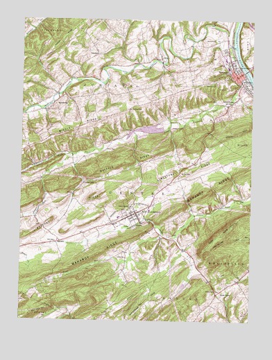
Newport, PA USGS Topographic Map
Click on map above to begin viewing in our Map Viewer.

This topographic map contains these locations and features:
Feature Name Type Latitude Longitude GNIS ID View Map
Airy View SchoolSchoolN40.4365°W77.1628°1168098View Map
American Legion Country ClubLocaleN40.4718°W77.1397°1197868View Map
Bloomfield Junction (historical)LocaleN40.4037°W77.2330°1197018View Map
Borough of BloomfieldCivilN40.4189°W77.1890°1215523View Map
Borough of NewportCivilN40.4793°W77.1336°1215530View Map
Box Huckleberry Natural AreaAreaN40.4062°W77.1739°1212830View Map
Buffalo CreekStreamN40.4895°W77.1355°1170604View Map
Buffalo RidgeRidgeN40.4398°W77.1972°1170614View Map
Carson Long InstituteSchoolN40.4220°W77.1897°1171271View Map
Center SchoolSchoolN40.4859°W77.2083°1171451View Map
Centre SchoolSchoolN40.4079°W77.2308°1171516View Map
Citizens Fire Company 1BuildingN40.4754°W77.1306°2645186View Map
Dark HollowValleyN40.4089°W77.1336°1172932View Map
Dark Hollow TrailTrailN40.4084°W77.1330°1208338View Map
Eckerd DamDamN40.4148°W77.1864°1173970View Map
Evangelical United Brethren ChurchChurchN40.3934°W77.1297°1208339View Map
Fickes FieldParkN40.4817°W77.1391°1174728View Map
Fox FieldAirportN40.4865°W77.2189°2442821View Map
Hoffman (historical)LocaleN40.4251°W77.1278°1197020View Map
Jericho SchoolSchoolN40.4012°W77.1919°1178050View Map
Juniata FurnacePopulated PlaceN40.4554°W77.1683°1203906View Map
Kitner AirportAirportN40.4124°W77.2420°2442783View Map
Laurel Grove SchoolSchoolN40.4320°W77.2155°1178937View Map
Little Buffalo CreekStreamN40.4751°W77.1264°1192794View Map
Little Buffalo Creek DamDamN40.4548°W77.1728°1194824View Map
Little Buffalo LakeReservoirN40.4543°W77.1806°1212831View Map
Little Buffalo State ParkParkN40.4518°W77.1730°1198262View Map
Little Juniata ParkParkN40.4193°W77.1469°1208340View Map
Lower Ridge SchoolSchoolN40.4629°W77.1900°1180031View Map
Lutman RunStreamN40.4437°W77.2217°1180089View Map
Mahanoy (historical)LocaleN40.4179°W77.1547°1197021View Map
Mahanoy RidgeRidgeN40.4281°W77.1505°1180207View Map
MarkelsvillePopulated PlaceN40.4656°W77.2319°1180417View Map
McKeePopulated PlaceN40.4276°W77.2211°1204136View Map
Mecks CornerPopulated PlaceN40.3862°W77.1428°1180856View Map
Negely DamDamN40.3901°W77.1597°1194781View Map
Negley PondReservoirN40.3898°W77.1607°1194782View Map
New BloomfieldPopulated PlaceN40.4198°W77.1864°1182289View Map
New Bloomfield Airport (historical)AirportN40.4040°W77.1783°1197019View Map
New Bloomfield Fire and Emergency Medical ServicesBuildingN40.4201°W77.1886°2645049View Map
New Bloomfield Post OfficePost OfficeN40.4190°W77.1853°2772864View Map
New Bloomfield Post Office (historical)Post OfficeN40.4195°W77.1866°1214254View Map
NewportPopulated PlaceN40.4779°W77.1305°1213994View Map
Newport Ambulance LeagueBuildingN40.4762°W77.1311°2719538View Map
Newport CemeteryCemeteryN40.4745°W77.1469°1182406View Map
Newport Post OfficePost OfficeN40.4788°W77.1327°2772875View Map
Perry County Sheriff's OfficeBuildingN40.4201°W77.1871°2781049View Map
State Game Lands Number 256ParkN40.4001°W77.1330°1208337View Map
Sylvan (historical)LocaleN40.4437°W77.2097°1197022View Map
Township of CentreCivilN40.4111°W77.2374°1216938View Map
Township of JuniataCivilN40.4723°W77.2119°1216942View Map
Township of OliverCivilN40.4872°W77.1430°1216946View Map
Trout RunStreamN40.4104°W77.1650°1189849View Map
Veterans Memorial ParkParkN40.4806°W77.1330°1190392View Map
WahnetaPopulated PlaceN40.4543°W77.1889°1204887View Map
Water PlugLocaleN40.4462°W77.2033°1190662View Map
Weldons Airport (historical)AirportN40.3834°W77.1275°1193965View Map
WilaPopulated PlaceN40.4840°W77.1736°1191384View Map
Wolf Rock HillSummitN40.3773°W77.2447°1191666View Map

Note: Coordinates in the location and feature list above are referenced to NAD83 datum.


Copyright (C) 2008-2024 Ryan Niemi / Sunset Dynamics ... All Rights Reserved