TopoQuest Logo
Do you find TopoQuest useful?
Help keep TopoQuest running and adding new maps/features by donating!
Bitcoin:  19c7KJd3qBynnjoSw5npx9KScwjBe4ifkT
Litecoin:  LXs6TkuXGGXo1vDsWCkWVdjQX94eUKd6ui
Home View Maps Find Maps Find Places Resources & Links


Minerva, Ohio Topographic Map

USGS Map Title: Minerva, OH
USGS Map MRC: 40081F1
DRG (GeoTIFF) Download: o40081f1.tif


Neighboring USGS Topographic Map Quads:


  Robertsville, OH  
40081G2
 

  Homeworth, OH  
40081G1
 

  Hanoverton, OH  
40080G8
 

  Malvern, OH  
40081F2
 

  Minerva, OH  
40081F1
 

  Kensington, OH  
40080F8
 

  Dellroy, OH  
40081E2
 

  Carrollton, OH  
40081E1
 

  Bergholz, OH  
40080E8


Map MRC Location:

N41°
W82°
N41°
W81°
H8 H7 H6 H5 H4 H3 H2 H1
G8 G7 G6 G5 G4 G3 G2 G1
F8 F7 F6 F5 F4 F3 F2 F1
E8 E7 E6 E5 E4 E3 E2 E1
D8 D7 D6 D5 D4 D3 D2 D1
C8 C7 C6 C5 C4 C3 C2 C1
B8 B7 B6 B5 B4 B3 B2 B1
A8 A7 A6 A5 A4 A3 A2 A1
N40°
W82°
N40°
W81°

Minerva, OH USGS 1:24K Topographic Map Preview:
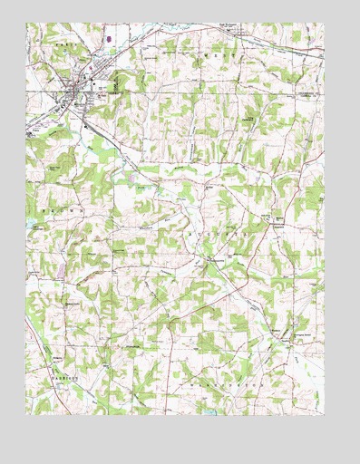
Minerva, OH USGS Topographic Map
Click on map above to begin viewing in our Map Viewer.

This topographic map contains these locations and features:
Feature Name Type Latitude Longitude GNIS ID View Map
AugustaPopulated PlaceN40.6859°W81.0209°1070668View Map
Augusta CemeteryCemeteryN40.6881°W81.0207°1052404View Map
Augusta Elementary SchoolSchoolN40.6876°W81.0240°1052403View Map
Augusta Post OfficePost OfficeN40.6862°W81.0206°1965225View Map
Bartleys Ambulance ServiceBuildingN40.7297°W81.1048°2550915View Map
Bird CemeteryCemeteryN40.6761°W81.0403°1060875View Map
Browns School (historical)SchoolN40.6684°W81.1087°1052393View Map
Camp ChristopherLocaleN40.7187°W81.0304°1038674View Map
Camp ConestogaLocaleN40.6848°W81.1218°1038678View Map
Camp Conestoga LakeReservoirN40.6862°W81.1227°1078427View Map
Camp Conestoga Lake DamDamN40.6851°W81.1248°1078426View Map
Chestnut Knob CemeteryCemeteryN40.6773°W81.0884°1039046View Map
Church of ChristChurchN40.7301°W81.1062°1079895View Map
Conser RunStreamN40.7487°W81.0440°1039321View Map
Crawford CemeteryCemeteryN40.6664°W81.0034°1039458View Map
Dewey Hall School (historical)SchoolN40.6548°W81.0648°1052396View Map
Dunlap School (historical)SchoolN40.6334°W81.1079°1052390View Map
East RochesterPopulated PlaceN40.7462°W81.0351°1064588View Map
East Rochester Census Designated PlaceCensusN40.7495°W81.0399°2628889View Map
East Rochester Post OfficePost OfficeN40.7459°W81.0345°1966450View Map
Enterprise School (historical)SchoolN40.7051°W81.0426°1052400View Map
Eureka School (historical)SchoolN40.7073°W81.0084°1052405View Map
Francis Haven Middle SchoolSchoolN40.7312°W81.1029°1057557View Map
Friends Church (historical)ChurchN40.7270°W81.0118°1052406View Map
Great Trail CampLocaleN40.7028°W81.1151°1041095View Map
Harsh - Swamp CemeteryCemeteryN40.6414°W81.0890°1052391View Map
Harsh ChurchChurchN40.6412°W81.0898°1041368View Map
Herrington Bethel CemeteryCemeteryN40.6495°W81.0126°1052402View Map
Herrington Bethel ChurchChurchN40.6492°W81.0123°1041502View Map
HibbettsPopulated PlaceN40.6420°W81.1126°1064829View Map
Hibbetts AirportAirportN40.6378°W81.1130°1082551View Map
Hibbetts Post Office (historical)Post OfficeN40.6417°W81.1123°1083275View Map
Hostetter School (historical)SchoolN40.7476°W81.1048°1057558View Map
Kidder Trailer ParkPopulated PlaceN40.7250°W81.1039°2553846View Map
Manfull ChurchChurchN40.6876°W81.0209°1042919View Map
Mary Irene Day Elementary SchoolSchoolN40.7306°W81.0962°1079993View Map
MinervaPopulated PlaceN40.7298°W81.1054°1056427View Map
Minerva CemeteryCemeteryN40.7248°W81.1065°1079991View Map
Minerva Fire DepartmentBuildingN40.7314°W81.0984°2549285View Map
Minerva High SchoolSchoolN40.7356°W81.0979°1057556View Map
Minerva Police DepartmentBuildingN40.7293°W81.1034°2732532View Map
Minerva Post OfficePost OfficeN40.7289°W81.1040°1083496View Map
Minerva Post OfficePost OfficeN40.7292°W81.1054°2057311View Map
Minerva Town HallBuildingN40.7292°W81.1032°1079896View Map
Moore CemeteryCemeteryN40.7064°W81.0537°1043468View Map
Mount Zion CemeteryCemeteryN40.6984°W81.0490°1052399View Map
Mount Zion ChurchChurchN40.6981°W81.0501°1061165View Map
Muddy ForkStreamN40.7031°W81.0845°1043716View Map
Muddy Fork School (historical)SchoolN40.7092°W81.0762°1052398View Map
Murray Avenue Church of GodChurchN40.7273°W81.1007°1079871View Map
Oak Ridge School (historical)SchoolN40.6989°W81.1143°1052394View Map
Parsons AirportAirportN40.6482°W81.0641°1074878View Map
PattersonvillePopulated PlaceN40.6745°W81.0484°1052397View Map
Pattersonville Post Office (historical)Post OfficeN40.6751°W81.0484°1083282View Map
PekinPopulated PlaceN40.7170°W81.1223°1056474View Map
Pekin Post Office (historical)Post OfficeN40.7167°W81.1220°1965219View Map
Pipes ForkStreamN40.6506°W81.0223°1044498View Map
Plaines CemeteryCemeteryN40.7417°W81.0762°1044514View Map
Pleasant Grove CemeteryCemeteryN40.6589°W81.1087°1052392View Map
Pleasant Grove CemeteryCemeteryN40.6698°W81.1234°1061177View Map
Pleasant Grove ChurchChurchN40.6595°W81.1082°1044534View Map
Pumpkin RunStreamN40.6792°W81.0529°1044797View Map
Quaker Church CemeteryCemeteryN40.7270°W81.0118°1061180View Map
Reeds RunStreamN40.6698°W81.0459°1044916View Map
Saint Pauls ChurchChurchN40.7273°W81.0957°1061190View Map
Shenandoah ValleyValleyN40.7045°W81.0570°1046179View Map
SpechtPopulated PlaceN40.6481°W81.0145°1065363View Map
Specht Post Office (historical)Post OfficeN40.6487°W81.0151°1083285View Map
Stahl School (historical)SchoolN40.6395°W81.0651°1052395View Map
Still ForkStreamN40.7164°W81.1087°1046692View Map
Still Fork ChurchChurchN40.6873°W81.0234°1046693View Map
Still Fork Church CemeteryCemeteryN40.6720°W81.0504°1061209View Map
Still Fork Church CemeteryCemeteryN40.6845°W81.0368°1061210View Map
Stony HollowValleyN40.7056°W81.0365°1046734View Map
Stuller CemeteryCemeteryN40.6303°W81.0512°1061213View Map
Tennessee Gas LakeReservoirN40.6261°W81.0473°1078429View Map
Tennessee Gas Lake DamDamN40.6259°W81.0451°1078428View Map
Town And Country Park EstatesPopulated PlaceN40.7478°W81.0717°2547758View Map
Township of AugustaCivilN40.6864°W81.0410°1085824View Map
Village of MinervaCivilN40.7307°W81.1022°2399372View Map
WatheysPopulated PlaceN40.6514°W81.0223°1063082View Map
Weir School (historical)SchoolN40.6309°W81.0270°1052401View Map
West Elementary SchoolSchoolN40.7478°W81.0404°1052129View Map
West Lawn CemeteryCemeteryN40.7289°W81.0959°1047776View Map
Wholebark RunStreamN40.6906°W81.0573°1065738View Map
Woheld LakeReservoirN40.6710°W81.1099°1074879View Map

Note: Coordinates in the location and feature list above are referenced to NAD83 datum.


Copyright (C) 2008-2025 Ryan Niemi / Sunset Dynamics ... All Rights Reserved