TopoQuest Logo
Do you find TopoQuest useful?
Help keep TopoQuest running and adding new maps/features by donating!
Bitcoin:  19c7KJd3qBynnjoSw5npx9KScwjBe4ifkT
Litecoin:  LXs6TkuXGGXo1vDsWCkWVdjQX94eUKd6ui
Home View Maps Find Maps Find Places Resources & Links


McClellanville, South Carolina Topographic Map

USGS Map Title: McClellanville, SC
USGS Map MRC: 33079A4
DRG (GeoTIFF) Download: o33079a4.tif


Neighboring USGS Topographic Map Quads:


  Honey Hill, SC  
33079B5
 

  South Santee, SC  
33079B4
 

  Minim Island, SC  
33079B3
 

  Awendaw, SC  
33079A5
 

  McClellanville, SC  
33079A4
 

  Cape Romain, SC  
33079A3
 

  Bull Island, SC  
32079H5


Map MRC Location:

N34°
W80°
N34°
W79°
H8 H7 H6 H5 H4 H3 H2 H1
G8 G7 G6 G5 G4 G3 G2 G1
F8 F7 F6 F5 F4 F3 F2 F1
E8 E7 E6 E5 E4 E3 E2 E1
D8 D7 D6 D5 D4 D3 D2 D1
C8 C7 C6 C5 C4 C3 C2 C1
B8 B7 B6 B5 B4 B3 B2 B1
A8 A7 A6 A5 A4 A3 A2 A1
N33°
W80°
N33°
W79°

McClellanville, SC USGS 1:24K Topographic Map Preview:
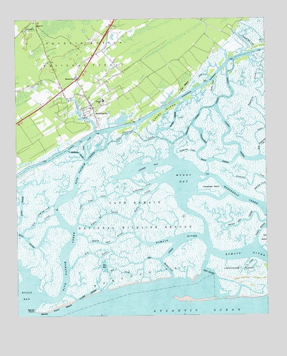
McClellanville, SC USGS Topographic Map
Click on map above to begin viewing in our Map Viewer.

This topographic map contains these locations and features:
Feature Name Type Latitude Longitude GNIS ID View Map
Awendaw Fire Department Station 5BuildingN33.0978°W79.4674°2368228View Map
Awendaw Fire District Station 4BuildingN33.0913°W79.4813°2368225View Map
Bay CreekGutN33.0188°W79.4481°1229382View Map
Bull RiverGutN33.0327°W79.4948°1229482View Map
Cape Romain WildernessReserveN33.0216°W79.4785°2035538View Map
Casino CreekGutN33.0729°W79.3906°1229526View Map
Chain Gang Camp Number 5 (historical)LocaleN33.0979°W79.4928°1252733View Map
Charleston County Public Library McClellanville BranchBuildingN33.0885°W79.4625°2490381View Map
Charleston County Sheriff's Office SubstationBuildingN33.0808°W79.4592°2334852View Map
Clark CreekGutN33.0093°W79.4656°1229559View Map
Clubhouse CreekGutN33.0757°W79.4376°1229567View Map
Congaree Boat CreekGutN33.0654°W79.4042°1229584View Map
Devils Den CreekStreamN33.0402°W79.3753°1229633View Map
DuPre CreekGutN33.0668°W79.4220°1229658View Map
DuPre CreekGutN33.1002°W79.4076°1229659View Map
Dupre CreekGutN33.0827°W79.4203°1229668View Map
Five Fathom CreekGutN33.0463°W79.4803°1229700View Map
Horsehead CreekGutN33.0493°W79.3867°1229823View Map
Horsehead IslandIslandN33.0543°W79.4014°1229824View Map
Island CutChannelN33.0746°W79.4484°1229842View Map
Jeremy CreekStreamN33.0785°W79.4598°1229849View Map
Jeremy IslandIslandN33.0860°W79.4262°1229850View Map
Joe and Ben CreekGutN33.0693°W79.4151°1229861View Map
Key BayBayN33.0213°W79.4567°1229880View Map
Key CreekGutN33.0227°W79.4434°1229882View Map
Key InletGutN33.0210°W79.4064°1229883View Map
Lighthouse IslandIslandN33.0196°W79.3876°1229907View Map
Lincoln High SchoolSchoolN33.0912°W79.4558°1229908View Map
Little Papas CreekGutN33.0527°W79.4506°1229929View Map
Little Sett CreekStreamN33.0402°W79.4898°1229936View Map
Mathews CreekGutN33.0691°W79.4684°1229974View Map
Mathews CutChannelN33.0735°W79.4687°1229975View Map
McClellanvillePopulated PlaceN33.0882°W79.4612°1252622View Map
McClellanville Historic DistrictParkN33.0879°W79.4615°1253000View Map
McClellanville Lookout TowerTowerN33.0816°W79.4595°1242503View Map
McClellanville Magistrate OfficeBuildingN33.0973°W79.4942°2490455View Map
McClellanville Middle SchoolSchoolN33.0879°W79.4624°2044586View Map
Mill CreekGutN33.0757°W79.3798°1230006View Map
Mill Den CreekGutN33.0541°W79.3784°1230013View Map
Moores CornerPopulated PlaceN33.1002°W79.4690°1230035View Map
Muddy BayBayN33.0577°W79.4162°1230076View Map
Needles Eye CreekStreamN33.0716°W79.3776°1230087View Map
Nellie CreekGutN33.0504°W79.4373°1230090View Map
Ormand Hall CreekStreamN33.1107°W79.3862°1230131View Map
Oyster BayBayN33.0632°W79.4334°1230137View Map
Papas CreekGutN33.0429°W79.4562°1230141View Map
Raccoon CreekGutN33.0199°W79.4248°1230213View Map
Raccoon KeyIslandN33.0182°W79.4206°1228010View Map
Ramhorn CreekGutN33.0954°W79.3792°1230216View Map
Rhems ChurchChurchN33.1229°W79.4892°1230237View Map
Saint Peters ChurchChurchN33.1216°W79.4945°1230279View Map
Sall CreekStreamN33.1177°W79.3862°1230287View Map
Sandy PointCapeN33.0013°W79.4917°1230296View Map
Sandy Point BeachBeachN33.0088°W79.4567°1230297View Map
Santee Path CreekGutN33.0307°W79.4545°1230301View Map
Sett CreekStreamN33.0354°W79.4973°1230314View Map
Silver Hill PlantationLocaleN33.0838°W79.4806°1253250View Map
Skrine CreekGutN33.0813°W79.4114°1230331View Map
Slack ReachChannelN33.0352°W79.3781°1230332View Map
South CreekStreamN33.0241°W79.3834°1230343View Map
The BeachLocaleN33.0963°W79.4145°1230402View Map
The Village MuseumBuildingN33.0808°W79.4592°2490427View Map
Town CreekGutN33.0729°W79.4645°1230419View Map
Town of McClellanvilleCivilN33.0865°W79.4680°2406123View Map
United States Forest Service WambaughBuildingN33.0969°W79.4687°2578275View Map
Wambaw District Ranger OfficeLocaleN33.0985°W79.4695°1230592View Map

Note: Coordinates in the location and feature list above are referenced to NAD83 datum.


Copyright (C) 2008-2025 Ryan Niemi / Sunset Dynamics ... All Rights Reserved