TopoQuest Logo
Do you find TopoQuest useful?
Help keep TopoQuest running and adding new maps/features by donating!
Bitcoin:  19c7KJd3qBynnjoSw5npx9KScwjBe4ifkT
Litecoin:  LXs6TkuXGGXo1vDsWCkWVdjQX94eUKd6ui
Home View Maps Find Maps Find Places Resources & Links


Mission Lake, Wisconsin Topographic Map

USGS Map Title: Mission Lake, WI
USGS Map MRC: 44089G3
DRG (GeoTIFF) Download: o44089g3.tif


Neighboring USGS Topographic Map Quads:


  Ringle, WI  
44089H4
 

  Hatley, WI  
44089H3
 

  Birnamwood, WI  
44089H2
 

  Bevent, WI  
44089G4
 

  Mission Lake, WI  
44089G3
 

  Wittenberg, WI  
44089G2
 

  Rosholt NW, WI  
44089F4
 

  Rosholt, WI  
44089F3
 

  Tigerton NW, WI  
44089F2


Map MRC Location:

N45°
W90°
N45°
W89°
H8 H7 H6 H5 H4 H3 H2 H1
G8 G7 G6 G5 G4 G3 G2 G1
F8 F7 F6 F5 F4 F3 F2 F1
E8 E7 E6 E5 E4 E3 E2 E1
D8 D7 D6 D5 D4 D3 D2 D1
C8 C7 C6 C5 C4 C3 C2 C1
B8 B7 B6 B5 B4 B3 B2 B1
A8 A7 A6 A5 A4 A3 A2 A1
N44°
W90°
N44°
W89°

Mission Lake, WI USGS 1:24K Topographic Map Preview:
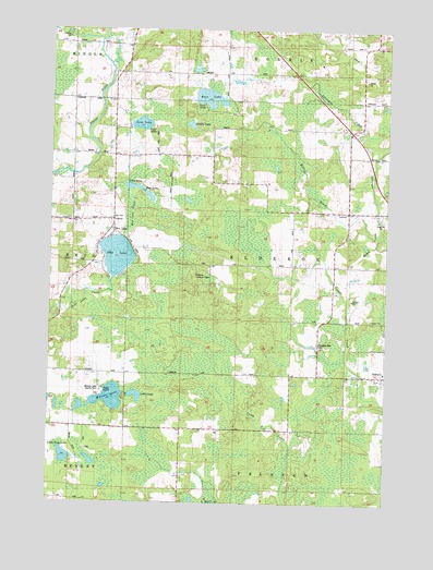
Mission Lake, WI USGS Topographic Map
Click on map above to begin viewing in our Map Viewer.

This topographic map contains these locations and features:
Feature Name Type Latitude Longitude GNIS ID View Map
Bass LakeLakeN44.8570°W89.3168°1561231View Map
Bass Lake School (historical)SchoolN44.8664°W89.3093°1876670View Map
East Reid School (historical)SchoolN44.8425°W89.3671°1876684View Map
Elderon Lookout TowerTowerN44.8100°W89.3204°1581210View Map
Elderon Village Volunteer Fire DepartmentBuildingN44.7836°W89.2509°2696965View Map
Evergreen Rest CemeteryCemeteryN44.7922°W89.2757°1564775View Map
IngersollPopulated PlaceN44.8519°W89.2598°1876701View Map
Kingdom Hall ChurchChurchN44.7983°W89.2721°1567507View Map
Leterski FarmsLocaleN44.7689°W89.3508°2723276View Map
Little Frog LakeLakeN44.7622°W89.3691°1568262View Map
Little LakeLakeN44.7782°W89.3426°1568300View Map
Litza FarmsLocaleN44.8689°W89.3117°2723277View Map
Lost LakeLakeN44.8500°W89.3416°1568656View Map
McVay BrookStreamN44.8202°W89.2534°1569276View Map
Mission LakeLakeN44.7777°W89.3524°1569611View Map
Mission Lake County ParkParkN44.7791°W89.3557°1844196View Map
Muddy LakeLakeN44.8497°W89.3229°1570007View Map
Pike LakePopulated PlaceN44.8216°W89.3518°1845225View Map
Pike LakeLakeN44.8153°W89.3501°1571380View Map
Pike Lake School (historical)SchoolN44.8244°W89.3521°1876722View Map
Rice LakeLakeN44.8331°W89.3421°1572255View Map
Rice Lake CreekStreamN44.8194°W89.3476°1572274View Map
Ripple Ridge FarmsLocaleN44.8358°W89.3658°2723281View Map
Schmidt FarmLocaleN44.8558°W89.3678°2723282View Map
Town of ElderonCivilN44.8138°W89.2865°1583144View Map

Note: Coordinates in the location and feature list above are referenced to NAD83 datum.


Copyright (C) 2008-2025 Ryan Niemi / Sunset Dynamics ... All Rights Reserved