TopoQuest Logo
Do you find TopoQuest useful?
Help keep TopoQuest running and adding new maps/features by donating!
Bitcoin:  19c7KJd3qBynnjoSw5npx9KScwjBe4ifkT
Litecoin:  LXs6TkuXGGXo1vDsWCkWVdjQX94eUKd6ui
Home View Maps Find Maps Find Places Resources & Links


Hatley, Wisconsin Topographic Map

USGS Map Title: Hatley, WI
USGS Map MRC: 44089H3
DRG (GeoTIFF) Download: o44089h3.tif


Neighboring USGS Topographic Map Quads:


  Kalinke, WI  
45089A4
 

  Hogarty, WI  
45089A3
 

  Aniwa, WI  
45089A2
 

  Ringle, WI  
44089H4
 

  Hatley, WI  
44089H3
 

  Birnamwood, WI  
44089H2
 

  Bevent, WI  
44089G4
 

  Mission Lake, WI  
44089G3
 

  Wittenberg, WI  
44089G2


Map MRC Location:

N45°
W90°
N45°
W89°
H8 H7 H6 H5 H4 H3 H2 H1
G8 G7 G6 G5 G4 G3 G2 G1
F8 F7 F6 F5 F4 F3 F2 F1
E8 E7 E6 E5 E4 E3 E2 E1
D8 D7 D6 D5 D4 D3 D2 D1
C8 C7 C6 C5 C4 C3 C2 C1
B8 B7 B6 B5 B4 B3 B2 B1
A8 A7 A6 A5 A4 A3 A2 A1
N44°
W90°
N44°
W89°

Hatley, WI USGS 1:24K Topographic Map Preview:
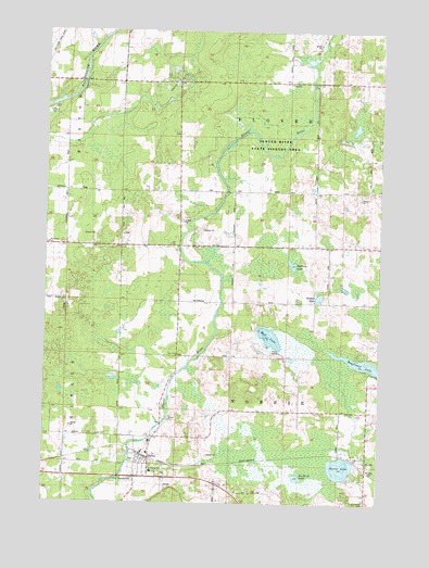
Hatley, WI USGS Topographic Map
Click on map above to begin viewing in our Map Viewer.

This topographic map contains these locations and features:
Feature Name Type Latitude Longitude GNIS ID View Map
Birnamwood ChurchChurchN44.9433°W89.3357°1561823View Map
Bluegill LakeLakeN44.9132°W89.2826°2770685View Map
Bohnes LakeLakeN44.9298°W89.2725°1562028View Map
Forestville ChurchChurchN44.9436°W89.3718°1565148View Map
Go-To-It LakeLakeN44.8822°W89.2800°1565591View Map
HatleyPopulated PlaceN44.8875°W89.3387°1566132View Map
Hatley Elementary SchoolSchoolN44.8880°W89.3361°1844149View Map
Hatley Volunteer Fire DepartmentBuildingN44.8873°W89.3375°2696934View Map
Hillcrest CemeteryCemeteryN44.8847°W89.2526°1844155View Map
Marathon County Public Library Hatley BranchBuildingN44.8886°W89.3378°2722996View Map
Mayflower LakeLakeN44.9119°W89.2549°1569148View Map
Mud LakeLakeN44.9192°W89.2911°1569932View Map
Mystery LakeLakeN44.9384°W89.2829°1570089View Map
NorriePopulated PlaceN44.8855°W89.2543°1570339View Map
Norrie LakeLakeN44.8846°W89.2639°1570341View Map
Plover Valley School (historical)SchoolN44.9575°W89.3146°1876725View Map
Saint Florian Parish CemeteryCemeteryN44.8828°W89.3317°2768254View Map
Saint Florians Grade SchoolSchoolN44.8833°W89.3346°1845246View Map
Saint Francis CemeteryCemeteryN44.8752°W89.2546°1572930View Map
Town of NorrieCivilN44.9000°W89.2840°1583823View Map
Town of PloverCivilN44.9863°W89.2851°1583940View Map
Trunk Line School (historical)SchoolN44.9436°W89.2646°1876750View Map
Village of HatleyCivilN44.8858°W89.3371°1583364View Map
Wayside ParkParkN44.8816°W89.3462°1576360View Map
Woodland School (historical)SchoolN44.9214°W89.3221°1876761View Map

Note: Coordinates in the location and feature list above are referenced to NAD83 datum.


Copyright (C) 2008-2024 Ryan Niemi / Sunset Dynamics ... All Rights Reserved