TopoQuest Logo
Do you find TopoQuest useful?
Help keep TopoQuest running and adding new maps/features by donating!
Bitcoin:  19c7KJd3qBynnjoSw5npx9KScwjBe4ifkT
Litecoin:  LXs6TkuXGGXo1vDsWCkWVdjQX94eUKd6ui
Home View Maps Find Maps Find Places Resources & Links


Mokelumne Hill, California Topographic Map

USGS Map Title: Mokelumne Hill, CA
USGS Map MRC: 38120C6
DRG (GeoTIFF) Download: o38120c6.tif


Neighboring USGS Topographic Map Quads:


  Amador City, CA  
38120D7
 

  Pine Grove, CA  
38120D6
 

  West Point, CA  
38120D5
 

  Jackson, CA  
38120C7
 

  Mokelumne Hill, CA  
38120C6
 

  Rail Road Flat, CA  
38120C5
 

  Valley Springs, CA  
38120B7
 

  San Andreas, CA  
38120B6
 

  Calaveritas, CA  
38120B5


Map MRC Location:

N39°
W121°
N39°
W120°
H8 H7 H6 H5 H4 H3 H2 H1
G8 G7 G6 G5 G4 G3 G2 G1
F8 F7 F6 F5 F4 F3 F2 F1
E8 E7 E6 E5 E4 E3 E2 E1
D8 D7 D6 D5 D4 D3 D2 D1
C8 C7 C6 C5 C4 C3 C2 C1
B8 B7 B6 B5 B4 B3 B2 B1
A8 A7 A6 A5 A4 A3 A2 A1
N38°
W121°
N38°
W120°

Mokelumne Hill, CA USGS 1:24K Topographic Map Preview:
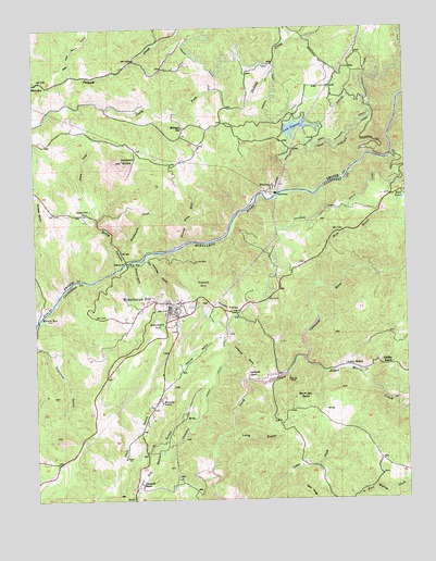
Mokelumne Hill, CA USGS Topographic Map
Click on map above to begin viewing in our Map Viewer.

This topographic map contains these locations and features:
Feature Name Type Latitude Longitude GNIS ID View Map
Big BarPopulated PlaceN38.3119°W120.7199°1659695View Map
Blue Jay MineMineN38.2821°W120.6655°219498View Map
Blue Jay PointSummitN38.2774°W120.6613°1658082View Map
Butte CanyonValleyN38.3124°W120.7208°220286View Map
Butte City (historical)LocaleN38.3257°W120.7352°233586View Map
Calaveras Public Utility DitchCanalN38.3210°W120.6677°220377View Map
Chili Gulch PitMineN38.2606°W120.7217°2676068View Map
China GulchValleyN38.3307°W120.7344°221036View Map
Congregational ChurchChurchN38.3002°W120.7066°1804796View Map
ElectraPopulated PlaceN38.3321°W120.6713°1658485View Map
French HillSummitN38.3071°W120.6944°1658582View Map
Ginocchio Store (historical)LocaleN38.3257°W120.7352°1733310View Map
Guffra RanchLocaleN38.2857°W120.6316°224707View Map
Happy ValleyFlatN38.2996°W120.6858°224903View Map
Happy ValleyPopulated PlaceN38.2999°W120.6838°1804800View Map
Hundred Ounce GulchValleyN38.3180°W120.7008°225766View Map
Hunt GulchValleyN38.3049°W120.7427°225780View Map
Jackson ButteSummitN38.3399°W120.7213°226074View Map
Jesus MariaPopulated PlaceN38.2855°W120.6474°1658860View Map
Jesus Maria CreekStreamN38.2871°W120.6608°266859View Map
KNGT-FM (Jackson)TowerN38.3399°W120.7213°1665044View Map
Lake TabeaudReservoirN38.3483°W120.6633°235951View Map
Lake Tabeaud 97-067 DamDamN38.3482°W120.6669°1663639View Map
Le Roi MineMineN38.3127°W120.6977°226982View Map
Lombardi GulchValleyN38.2816°W120.6797°227498View Map
Lombardi RanchLocaleN38.2541°W120.7160°227499View Map
Lombardi RanchLocaleN38.2827°W120.6797°227500View Map
Long GulchValleyN38.2660°W120.6902°227563View Map
McSorley RanchLocaleN38.2757°W120.7088°228452View Map
Middle BarLocaleN38.2980°W120.7491°228571View Map
Milligan District (historical)Populated PlaceN38.3480°W120.7008°1733336View Map
Milligan SchoolSchoolN38.3480°W120.7008°228759View Map
Mokelumne HillPopulated PlaceN38.3005°W120.7063°228901View Map
Mokelumne Hill 1084 DamDamN38.3099°W120.7127°1664424View Map
Mokelumne Hill Census Designated PlaceCensusN38.3056°W120.7061°2408855View Map
Mokelumne Hill Elementary SchoolSchoolN38.2988°W120.6991°1804804View Map
Mokelumne Hill Fire Protection DistrictBuildingN38.2988°W120.7032°2624478View Map
Mokelumne Hill Post OfficePost OfficeN38.3016°W120.7061°1804805View Map
Mokelumne Hill State Historic LandmarkParkN38.3005°W120.7047°1804806View Map
Mokelumne VistaLocaleN38.2946°W120.7205°1804807View Map
Mokulumne Hill PitMineN38.2889°W120.6939°2680937View Map
New York Ranch GulchValleyN38.3619°W120.7377°229507View Map
Pine Peak Number 4 82-003 DamDamN38.2516°W120.7010°1663545View Map
Rattlesnake CreekStreamN38.3160°W120.7224°231255View Map
Rich GulchPopulated PlaceN38.3302°W120.6310°252776View Map
Rich GulchValleyN38.3066°W120.6566°234562View Map
Saint Thomas Aquinas ChurchChurchN38.3007°W120.7038°1804812View Map
Slocum GulchValleyN38.3130°W120.7180°233296View Map
Spring GulchValleyN38.2796°W120.7072°235257View Map
Stockton HillSummitN38.2977°W120.7102°1659873View Map
Volunteer GulchValleyN38.3141°W120.7144°237130View Map
Wet GulchValleyN38.2794°W120.6352°237577View Map
Whale Boat Ferry (historical)CrossingN38.3155°W120.7202°1733374View Map

Note: Coordinates in the location and feature list above are referenced to NAD83 datum.


Copyright (C) 2008-2024 Ryan Niemi / Sunset Dynamics ... All Rights Reserved