TopoQuest Logo
Do you find TopoQuest useful?
Help keep TopoQuest running and adding new maps/features by donating!
Bitcoin:  19c7KJd3qBynnjoSw5npx9KScwjBe4ifkT
Litecoin:  LXs6TkuXGGXo1vDsWCkWVdjQX94eUKd6ui
Home View Maps Find Maps Find Places Resources & Links


West Point, California Topographic Map

USGS Map Title: West Point, CA
USGS Map MRC: 38120D5
DRG (GeoTIFF) Download: o38120d5.tif


Neighboring USGS Topographic Map Quads:


  Aukum, CA  
38120E6
 

  Omo Ranch, CA  
38120E5
 

  Caldor, CA  
38120E4
 

  Pine Grove, CA  
38120D6
 

  West Point, CA  
38120D5
 

  Devils Nose, CA  
38120D4
 

  Mokelumne Hill, CA  
38120C6
 

  Rail Road Flat, CA  
38120C5
 

  Fort Mountain, CA  
38120C4


Map MRC Location:

N39°
W121°
N39°
W120°
H8 H7 H6 H5 H4 H3 H2 H1
G8 G7 G6 G5 G4 G3 G2 G1
F8 F7 F6 F5 F4 F3 F2 F1
E8 E7 E6 E5 E4 E3 E2 E1
D8 D7 D6 D5 D4 D3 D2 D1
C8 C7 C6 C5 C4 C3 C2 C1
B8 B7 B6 B5 B4 B3 B2 B1
A8 A7 A6 A5 A4 A3 A2 A1
N38°
W121°
N38°
W120°

West Point, CA USGS 1:24K Topographic Map Preview:
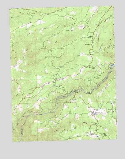
West Point, CA USGS Topographic Map
Click on map above to begin viewing in our Map Viewer.

This topographic map contains these locations and features:
Feature Name Type Latitude Longitude GNIS ID View Map
Amador Columbia MineMineN38.4144°W120.5680°218210View Map
Amador Fire Protection District Station 111BuildingN38.4570°W120.5332°2624678View Map
Amador Fire Protection District Station 112BuildingN38.4272°W120.5876°2624604View Map
Amador Ranger StationLocaleN38.4560°W120.5285°276165View Map
American Legion Ambulance Station 23BuildingN38.4020°W120.5286°2662260View Map
American Legion Ambulance Station 3BuildingN38.4414°W120.5564°2662263View Map
Antelope CreekStreamN38.4535°W120.5099°218296View Map
Ashland CreekStreamN38.4563°W120.6083°218434View Map
BartonPopulated PlaceN38.4546°W120.5302°252625View Map
Bear CreekStreamN38.3944°W120.5010°218823View Map
Belden MineMineN38.4355°W120.5205°218977View Map
Black Prince MineMineN38.4277°W120.5260°219399View Map
Brush Creek 1009-012 DamDamN38.4699°W120.6210°1664139View Map
BuckhornPopulated PlaceN38.4522°W120.5285°2652372View Map
Buckhorn Census Designated PlaceCensusN38.4531°W120.5355°2586444View Map
Buckhorn LodgeLocaleN38.4444°W120.5321°220057View Map
BummervillePopulated PlaceN38.4013°W120.5058°220146View Map
Calaveras County Rural ClinicHospitalN38.4141°W120.5283°1804794View Map
Canzatti SpringSpringN38.4424°W120.5285°220566View Map
China Hill QuarryMineN38.4242°W120.6244°2676069View Map
Department of Forestry and Fire Protection West PointBuildingN38.4041°W120.5273°2624183View Map
Electra Diversion 97-114 DamDamN38.4199°W120.5494°1663671View Map
Electra TunnelTunnelN38.3971°W120.6172°223083View Map
First Baptist Church of West PointChurchN38.3988°W120.5269°1804797View Map
Golden Gate CreekStreamN38.4635°W120.6052°224289View Map
Goodman RanchLocaleN38.4785°W120.5527°224309View Map
Inspiration LodgeLocaleN38.4830°W120.5199°225947View Map
Inspiration PointLocaleN38.4710°W120.5269°225950View Map
Little Mill CreekStreamN38.4627°W120.5060°227303View Map
Lockwood Fire Protection District Station 151BuildingN38.4888°W120.5932°2624063View Map
Lower Standard CanalCanalN38.4152°W120.5724°227792View Map
Lynn Park AcresPopulated PlaceN38.3894°W120.5127°1804803View Map
Mace Meadows Golf CourseLocaleN38.4535°W120.5344°1733333View Map
Marklay MineMineN38.4944°W120.5997°228126View Map
Mill CreekStreamN38.4488°W120.5008°263599View Map
Misery CreekStreamN38.4480°W120.5974°228827View Map
Mount CrossmanSummitN38.4652°W120.5330°1658354View Map
PioneerPopulated PlaceN38.4319°W120.5719°230751View Map
Pioneer Arts Elementary SchoolSchoolN38.4325°W120.5710°1733341View Map
Pioneer Census Designated PlaceCensusN38.4355°W120.5848°2583116View Map
Pioneer CreekStreamN38.4438°W120.6241°230756View Map
Pioneer Post OfficePost OfficeN38.4299°W120.5772°1733343View Map
Ranch House EstatesPopulated PlaceN38.4063°W120.6191°1733351View Map
Red Corral Census Designated PlaceCensusN38.4117°W120.6055°2583119View Map
Sandy GulchPopulated PlaceN38.3802°W120.5327°252787View Map
Sandy Gulch Field Baseball ParkParkN38.3810°W120.5338°1804813View Map
Sandy Gulch State Historic LandmarkParkN38.3805°W120.5327°1804814View Map
Skull FlatFlatN38.4224°W120.5144°233200View Map
T N T MineMineN38.4630°W120.5163°235950View Map
Tiger Creek Afterbay 97-105 DamDamN38.4416°W120.5052°1663661View Map
United States Forest Service Amador Ranger District AmbulanceBuildingN38.4523°W120.5268°2662317View Map
Upper Standard CanalCanalN38.4171°W120.5713°236925View Map
Volcano DitchCanalN38.4841°W120.5702°237128View Map
West PointPopulated PlaceN38.3991°W120.5274°255226View Map
West Point Alternative SchoolSchoolN38.4021°W120.5285°1804819View Map
West Point Branch Calaveras County LibraryBuildingN38.4007°W120.5296°1804820View Map
West Point California Division of Forestry StationLocaleN38.4038°W120.5271°1804821View Map
West Point Census Designated PlaceCensusN38.4043°W120.5373°2409563View Map
West Point Community HallBuildingN38.3955°W120.5271°1804822View Map
West Point Elementary SchoolSchoolN38.3984°W120.5261°1804823View Map
West Point Fire Protection District Station 1 HeadquartersBuildingN38.4011°W120.5304°2624058View Map
West Point Fire Protection District Station 2BuildingN38.3789°W120.5135°2624485View Map
West Point Post OfficePost OfficeN38.4018°W120.5286°1804824View Map
West Point Power HouseLocaleN38.4210°W120.5491°1654511View Map
West Point State Historic LandmarkParkN38.3999°W120.5280°1804825View Map
West Point TunnelTunnelN38.4324°W120.5277°237511View Map
WilseyvillePopulated PlaceN38.3791°W120.5146°1660185View Map
Wilseyville Post OfficePost OfficeN38.3785°W120.5164°2789159View Map
Yellow Aster MineMineN38.3988°W120.5755°238237View Map

Note: Coordinates in the location and feature list above are referenced to NAD83 datum.


Copyright (C) 2008-2025 Ryan Niemi / Sunset Dynamics ... All Rights Reserved