TopoQuest Logo
Do you find TopoQuest useful?
Help keep TopoQuest running and adding new maps/features by donating!
Bitcoin:  19c7KJd3qBynnjoSw5npx9KScwjBe4ifkT
Litecoin:  LXs6TkuXGGXo1vDsWCkWVdjQX94eUKd6ui
Home View Maps Find Maps Find Places Resources & Links


Montgomery City, Missouri Topographic Map

USGS Map Title: Montgomery City, MO
USGS Map MRC: 38091H5
DRG (GeoTIFF) Download: o38091h5.tif


Neighboring USGS Topographic Map Quads:


  Martinsburg, MO  
39091A6
 

  Wellsville, MO  
39091A5
 

  Buell, MO  
39091A4
 

  Williamsburg, MO  
38091H6
 

  Montgomery City, MO  
38091H5
 

  New Florence, MO  
38091H4
 

  Readsville, MO  
38091G6
 

  Americus, MO  
38091G5
 

  Pinnacle Lake, MO  
38091G4


Map MRC Location:

N39°
W92°
N39°
W91°
H8 H7 H6 H5 H4 H3 H2 H1
G8 G7 G6 G5 G4 G3 G2 G1
F8 F7 F6 F5 F4 F3 F2 F1
E8 E7 E6 E5 E4 E3 E2 E1
D8 D7 D6 D5 D4 D3 D2 D1
C8 C7 C6 C5 C4 C3 C2 C1
B8 B7 B6 B5 B4 B3 B2 B1
A8 A7 A6 A5 A4 A3 A2 A1
N38°
W92°
N38°
W91°

Montgomery City, MO USGS 1:24K Topographic Map Preview:
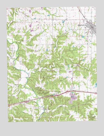
Montgomery City, MO USGS Topographic Map
Click on map above to begin viewing in our Map Viewer.

This topographic map contains these locations and features:
Feature Name Type Latitude Longitude GNIS ID View Map
Baldwin State Wildlife AreaParkN38.8767°W91.5404°742929View Map
Bates BranchStreamN38.9298°W91.5932°713726View Map
Bob Hoffman LakeReservoirN38.9168°W91.5695°760778View Map
City of Montgomery CityCivilN38.9737°W91.5024°2395382View Map
Clear ForkStreamN38.9278°W91.5949°715949View Map
Conley CemeteryCemeteryN38.9160°W91.6156°716193View Map
Conley School (historical)SchoolN38.9161°W91.6159°744434View Map
DanvillePopulated PlaceN38.9106°W91.5349°716660View Map
Danville Census Designated PlaceCensusN38.9126°W91.5324°2587062View Map
Davis BranchStreamN38.9134°W91.6018°716702View Map
Easterday DamDamN38.9150°W91.5002°761595View Map
Feldkamp Lake DamDamN38.9734°W91.5918°762064View Map
Graham Cave State ParkParkN38.9067°W91.5771°718654View Map
Graystone Park (historical)LocaleN38.9750°W91.5313°740475View Map
Gregory CemeteryCemeteryN38.9014°W91.5571°718861View Map
Harper School (historical)SchoolN38.9950°W91.6027°744430View Map
Hickory Meadows LakeReservoirN38.9534°W91.5690°761319View Map
Hoffman Lake DamDamN38.9184°W91.5685°760777View Map
Irvin Beabout DamDamN38.9367°W91.5402°764066View Map
Irvin Beabout LakeReservoirN38.9355°W91.5398°764067View Map
KMCR-FM (Montgomery City)TowerN38.9867°W91.5135°759142View Map
Lick BranchStreamN38.9625°W91.6063°721013View Map
Little Loutre CreekStreamN38.9653°W91.6249°721265View Map
Massey BranchStreamN38.9139°W91.6018°721962View Map
McClain Lake DamDamN38.9050°W91.5335°764750View Map
McIntosh BranchStreamN38.9628°W91.6127°722130View Map
MineolaPopulated PlaceN38.8881°W91.5716°722421View Map
Mineola State Wildlife AreaParkN38.9017°W91.5607°742930View Map
Montgomery CityPopulated PlaceN38.9775°W91.5049°729556View Map
Montgomery City CemeteryCemeteryN38.9716°W91.5137°2702481View Map
Montgomery City Elementary SchoolSchoolN38.9810°W91.5137°2651493View Map
Montgomery City Police DepartmentBuildingN38.9820°W91.5095°2752113View Map
Montgomery City Post OfficePost OfficeN38.9795°W91.5065°2782770View Map
Montgomery County Sheriff's OfficeBuildingN38.9793°W91.5048°2752279View Map
Montgomery Rural Fire Protection DistrictBuildingN38.9799°W91.5034°2621139View Map
Montgomery Volunteer Fire Protection DistrictBuildingN38.9797°W91.5037°2621124View Map
Nobles LakeReservoirN38.9290°W91.5373°764065View Map
Peytonia School (historical)SchoolN38.9434°W91.6113°744433View Map
Pierson LakeReservoirN38.9143°W91.5012°761596View Map
Pointdexter Lake DamDamN38.9967°W91.5935°761633View Map
Polizzi Lake DamDamN38.9517°W91.5702°761318View Map
Providence CemeteryCemeteryN38.9614°W91.6090°724965View Map
RGL FieldAirportN38.9856°W91.5368°2679363View Map
Rumbo BranchStreamN38.9300°W91.5799°729635View Map
Sallee BranchStreamN38.8862°W91.5749°729645View Map
Shore Crest LakeReservoirN38.9837°W91.5454°761588View Map
Sky-Vu AirportAirportN38.9007°W91.5648°2679365View Map
Smith BranchStreamN38.9434°W91.5566°726580View Map
Starr LakeReservoirN38.9994°W91.5754°762058View Map
Stevens Lake North DamDamN38.9784°W91.5918°762063View Map
Stevens Lake South DamDamN38.9700°W91.5918°762065View Map
Sturgeon Lake DamDamN38.9300°W91.5368°764064View Map
Sunny Hill School (historical)SchoolN38.9662°W91.5474°744432View Map
Township of DanvilleCivilN38.8882°W91.5312°767048View Map
Union Grove School (historical)SchoolN38.9973°W91.5443°744431View Map
Verbena Dale School (historical)SchoolN38.8974°W91.6113°744435View Map
Werges Lake DamDamN38.9817°W91.5452°761587View Map
Whetstone CreekStreamN38.9428°W91.6138°728699View Map
Worland CemeteryCemeteryN38.9639°W91.5235°729147View Map

Note: Coordinates in the location and feature list above are referenced to NAD83 datum.


Copyright (C) 2008-2024 Ryan Niemi / Sunset Dynamics ... All Rights Reserved