TopoQuest Logo
Do you find TopoQuest useful?
Help keep TopoQuest running and adding new maps/features by donating!
Bitcoin:  19c7KJd3qBynnjoSw5npx9KScwjBe4ifkT
Litecoin:  LXs6TkuXGGXo1vDsWCkWVdjQX94eUKd6ui
Home View Maps Find Maps Find Places Resources & Links


New Florence, Missouri Topographic Map

USGS Map Title: New Florence, MO
USGS Map MRC: 38091H4
DRG (GeoTIFF) Download: o38091h4.tif


Neighboring USGS Topographic Map Quads:


  Wellsville, MO  
39091A5
 

  Buell, MO  
39091A4
 

  Bellflower North, MO  
39091A3
 

  Montgomery City, MO  
38091H5
 

  New Florence, MO  
38091H4
 

  Bellflower South, MO  
38091H3
 

  Americus, MO  
38091G5
 

  Pinnacle Lake, MO  
38091G4
 

  Jonesburg, MO  
38091G3


Map MRC Location:

N39°
W92°
N39°
W91°
H8 H7 H6 H5 H4 H3 H2 H1
G8 G7 G6 G5 G4 G3 G2 G1
F8 F7 F6 F5 F4 F3 F2 F1
E8 E7 E6 E5 E4 E3 E2 E1
D8 D7 D6 D5 D4 D3 D2 D1
C8 C7 C6 C5 C4 C3 C2 C1
B8 B7 B6 B5 B4 B3 B2 B1
A8 A7 A6 A5 A4 A3 A2 A1
N38°
W92°
N38°
W91°

New Florence, MO USGS 1:24K Topographic Map Preview:
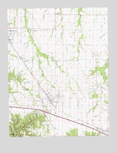
New Florence, MO USGS Topographic Map
Click on map above to begin viewing in our Map Viewer.

This topographic map contains these locations and features:
Feature Name Type Latitude Longitude GNIS ID View Map
Bethel Lake DamDamN38.8984°W91.4652°761561View Map
Carl Dreyer LakeReservoirN38.9367°W91.4866°760446View Map
Carl Dreyer Lake DamDamN38.9350°W91.4868°760445View Map
Cates DamDamN38.9284°W91.4768°760466View Map
Cates LakeReservoirN38.9289°W91.4752°760467View Map
City of High HillCivilN38.8753°W91.3777°2394374View Map
City of New FlorenceCivilN38.9093°W91.4529°2395192View Map
Contention School (historical)SchoolN38.9864°W91.4407°744437View Map
Crab Apple School (historical)SchoolN38.9437°W91.4982°744439View Map
Devault School (historical)SchoolN38.8948°W91.4435°744443View Map
Easterday East DamDamN38.9167°W91.4968°764134View Map
Fairview School (historical)SchoolN38.9045°W91.3910°744442View Map
High HillPopulated PlaceN38.8784°W91.3835°719521View Map
High Hill Post OfficePost OfficeN38.8778°W91.3813°2782704View Map
Johnson Lake DamDamN38.8817°W91.4685°762175View Map
Knox School (historical)SchoolN38.9042°W91.4999°744444View Map
Laclede School (historical)SchoolN38.9923°W91.4802°744436View Map
Montgomery CountyCivilN38.9415°W91.4702°758524View Map
Montgomery County High SchoolSchoolN38.9513°W91.4816°725031View Map
Montgomery County Middle SchoolSchoolN38.9530°W91.4834°2651373View Map
Mount Pleasant CemeteryCemeteryN38.8998°W91.3777°722850View Map
New FlorencePopulated PlaceN38.9103°W91.4482°729575View Map
New Florence CemeteryCemeteryN38.9100°W91.4627°723194View Map
New Florence Fire Protection DistrictBuildingN38.9118°W91.4468°2621418View Map
New Florence Police DepartmentBuildingN38.9090°W91.4475°2752573View Map
New Florence Post OfficePost OfficeN38.9097°W91.4482°2782719View Map
Number 219 ReservoirReservoirN38.9159°W91.4951°764135View Map
Orange Blossom School (historical)SchoolN38.9864°W91.3927°744438View Map
Pine Hall School (historical)SchoolN38.9431°W91.3752°744441View Map
Roy-L Incorporated DamDamN38.9234°W91.3852°762176View Map
Sunbeam School (historical)SchoolN38.9381°W91.4410°744440View Map
Wilkins AirportAirportN38.9703°W91.4419°2679364View Map

Note: Coordinates in the location and feature list above are referenced to NAD83 datum.


Copyright (C) 2008-2025 Ryan Niemi / Sunset Dynamics ... All Rights Reserved