TopoQuest Logo
Do you find TopoQuest useful?
Help keep TopoQuest running and adding new maps/features by donating!
Bitcoin:  19c7KJd3qBynnjoSw5npx9KScwjBe4ifkT
Litecoin:  LXs6TkuXGGXo1vDsWCkWVdjQX94eUKd6ui
Home View Maps Find Maps Find Places Resources & Links


Moorefield, Alabama Topographic Map

USGS Map Title: Moorefield, AL
USGS Map MRC: 32085G4
DRG (GeoTIFF) Download: o32085g4.tif


Neighboring USGS Topographic Map Quads:


  Dudleyville, AL  
32085H5
 

  Lafayette, AL  
32085H4
 

  Fredonia, AL  
32085H3
 

  Camp Hill SE, AL  
32085G5
 

  Moorefield, AL  
32085G4
 

  Cusseta, AL  
32085G3
 

  Waverly, AL  
32085F5
 

  Opelika West, AL  
32085F4
 

  Opelika East, AL  
32085F3


Map MRC Location:

N33°
W86°
N33°
W85°
H8 H7 H6 H5 H4 H3 H2 H1
G8 G7 G6 G5 G4 G3 G2 G1
F8 F7 F6 F5 F4 F3 F2 F1
E8 E7 E6 E5 E4 E3 E2 E1
D8 D7 D6 D5 D4 D3 D2 D1
C8 C7 C6 C5 C4 C3 C2 C1
B8 B7 B6 B5 B4 B3 B2 B1
A8 A7 A6 A5 A4 A3 A2 A1
N32°
W86°
N32°
W85°

Moorefield, AL USGS 1:24K Topographic Map Preview:
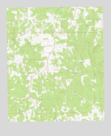
Moorefield, AL USGS Topographic Map
Click on map above to begin viewing in our Map Viewer.

This topographic map contains these locations and features:
Feature Name Type Latitude Longitude GNIS ID View Map
Antioch CemeteryCemeteryN32.8465°W85.4777°1805687View Map
Antioch CemeteryCemeteryN32.8365°W85.4699°1805694View Map
Antioch ChurchChurchN32.8360°W85.4705°113151View Map
Antioch ChurchChurchN32.8460°W85.4783°113152View Map
BoydsPopulated PlaceN32.8174°W85.4047°156103View Map
Boyds CemeteryCemeteryN32.8160°W85.4038°136016View Map
Caldwell CemeteryCemeteryN32.7571°W85.3794°147436View Map
Chambers AcademySchoolN32.8726°W85.4074°115921View Map
DanwayPopulated PlaceN32.7585°W85.3772°156248View Map
Dempsey DamDamN32.8335°W85.4466°131040View Map
Edgar DamDamN32.7601°W85.4583°131002View Map
Edgar LakeReservoirN32.7606°W85.4584°131003View Map
J H Hines DamDamN32.8718°W85.4266°131058View Map
J H Hines LakeReservoirN32.8723°W85.4264°131059View Map
Jeff Beard DamDamN32.7620°W85.4671°131006View Map
Jeff Beards LakeLakeN32.7633°W85.4663°136062View Map
Liberty ChurchChurchN32.8021°W85.4124°136069View Map
Liberty CrossroadsPopulated PlaceN32.8018°W85.4133°156606View Map
MoorefieldPopulated PlaceN32.8251°W85.4441°123023View Map
Moores CutLocaleN32.8543°W85.3969°123029View Map
New Mount Sellars ChurchChurchN32.8548°W85.4058°123869View Map
Oak BoweryPopulated PlaceN32.7507°W85.4363°152719View Map
Oak Bowery ChurchChurchN32.7524°W85.4377°136076View Map
Saint Johns ChurchChurchN32.8660°W85.4736°126125View Map
Spratling CemeteryCemeteryN32.7640°W85.4566°136089View Map
SturkiePopulated PlaceN32.7979°W85.4688°157121View Map
Sturkie CemeteryCemeteryN32.8001°W85.4697°136092View Map
Terrapin Creek Lake Number 21ReservoirN32.8718°W85.4700°131061View Map
Terrapin Creek Watershed Dam Number 21DamN32.8718°W85.4700°131060View Map
Waverly DivisionCivilN32.7802°W85.4961°165685View Map
West Chambers Volunteer Fire and RescueBuildingN32.8365°W85.4992°2691287View Map

Note: Coordinates in the location and feature list above are referenced to NAD83 datum.


Copyright (C) 2008-2024 Ryan Niemi / Sunset Dynamics ... All Rights Reserved