TopoQuest Logo
Do you find TopoQuest useful?
Help keep TopoQuest running and adding new maps/features by donating!
Bitcoin:  19c7KJd3qBynnjoSw5npx9KScwjBe4ifkT
Litecoin:  LXs6TkuXGGXo1vDsWCkWVdjQX94eUKd6ui
Home View Maps Find Maps Find Places Resources & Links


Lafayette, Alabama Topographic Map

USGS Map Title: Lafayette, AL
USGS Map MRC: 32085H4
DRG (GeoTIFF) Download: o32085h4.tif


Neighboring USGS Topographic Map Quads:


  Wadley South, AL  
33085A5
 

  Milltown, AL  
33085A4
 

  Five Points, AL  
33085A3
 

  Dudleyville, AL  
32085H5
 

  Lafayette, AL  
32085H4
 

  Fredonia, AL  
32085H3
 

  Camp Hill SE, AL  
32085G5
 

  Moorefield, AL  
32085G4
 

  Cusseta, AL  
32085G3


Map MRC Location:

N33°
W86°
N33°
W85°
H8 H7 H6 H5 H4 H3 H2 H1
G8 G7 G6 G5 G4 G3 G2 G1
F8 F7 F6 F5 F4 F3 F2 F1
E8 E7 E6 E5 E4 E3 E2 E1
D8 D7 D6 D5 D4 D3 D2 D1
C8 C7 C6 C5 C4 C3 C2 C1
B8 B7 B6 B5 B4 B3 B2 B1
A8 A7 A6 A5 A4 A3 A2 A1
N32°
W86°
N32°
W85°

Lafayette, AL USGS 1:24K Topographic Map Preview:
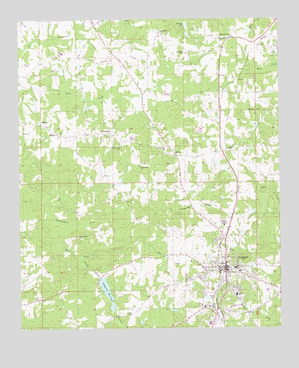
Lafayette, AL USGS Topographic Map
Click on map above to begin viewing in our Map Viewer.

This topographic map contains these locations and features:
Feature Name Type Latitude Longitude GNIS ID View Map
Batson Memorial SanitariumHospitalN32.9168°W85.4016°113570View Map
BuffaloPopulated PlaceN32.9462°W85.4019°115154View Map
Chambers CountyCivilN32.9144°W85.3920°161534View Map
Chambers County CourthouseBuildingN32.8996°W85.4005°136021View Map
Chambers County Hospital (historical)HospitalN32.8840°W85.4091°147437View Map
Chambers County Sheriff's OfficeBuildingN32.8994°W85.4007°2751986View Map
Chapel HillPopulated PlaceN32.9946°W85.4330°156168View Map
Chapel Hill ChurchChurchN32.9940°W85.4324°136023View Map
Cherry Grove Church (historical)ChurchN32.9448°W85.4349°162713View Map
City of La FayetteCivilN32.8997°W85.4007°2404846View Map
City of LaFayette Fire and Emergency Medical ServicesBuildingN32.8982°W85.4024°2691067View Map
Community ChurchChurchN32.9485°W85.4302°116475View Map
Eastside Elementary SchoolSchoolN32.8979°W85.3944°165408View Map
Finley CemeteryCemeteryN32.8812°W85.4463°118285View Map
Finley CreekStreamN32.9040°W85.4711°118290View Map
First Methodist Episcopal ChurchChurchN32.9015°W85.4011°136051View Map
First Presbyterian ChurchChurchN32.8979°W85.3997°164182View Map
Friendship Baptist ChurchChurchN32.8926°W85.4038°136056View Map
Friendship ChurchChurchN32.9868°W85.4208°118688View Map
Handy CemeteryCemeteryN32.8876°W85.4080°119672View Map
Hill-Thompson CemeteryCemeteryN32.9887°W85.4569°163391View Map
La Fayette DivisionCivilN32.8970°W85.4441°165681View Map
LafayettePopulated PlaceN32.8998°W85.4011°164071View Map
Lafayette CemeteryCemeteryN32.8960°W85.3944°163377View Map
Lafayette City HallBuildingN32.9001°W85.4019°163378View Map
Lafayette City Lake DamDamN32.8947°W85.4617°131086View Map
Lafayette City ParkParkN32.9065°W85.3977°163379View Map
LaFayette College (historical)SchoolN32.8993°W85.3983°136066View Map
Lafayette High SchoolSchoolN32.8996°W85.3966°136067View Map
Lafayette LibraryBuildingN32.8996°W85.4008°163380View Map
Lafayette Police DepartmentBuildingN32.9000°W85.4023°2751987View Map
LaFayette Post OfficePost OfficeN32.9000°W85.4018°169221View Map
Lafayette ReservoirReservoirN32.8900°W85.4583°151975View Map
Landrum CreekStreamN32.8751°W85.4502°121366View Map
Lebanon CemeteryCemeteryN32.9632°W85.3858°147443View Map
Lebanon Presbyterian ChurchChurchN32.9632°W85.3858°152010View Map
Macedonia CemeteryCemeteryN32.9543°W85.4811°147444View Map
Macedonia Primitive Baptist ChurchChurchN32.9546°W85.4813°152183View Map
MarcootPopulated PlaceN32.9579°W85.4891°156657View Map
Mill CreekStreamN32.9237°W85.4852°122768View Map
Mount Zion ChurchChurchN32.9271°W85.4213°123473View Map
Nolen DamDamN32.8885°W85.4133°131080View Map
Nolen LakeReservoirN32.8885°W85.4133°131079View Map
Old Rock Springs CemeteryCemeteryN32.9490°W85.4513°124238View Map
Pine Grove ChurchChurchN32.9923°W85.4036°124793View Map
Poplar Springs CemeteryCemeteryN32.9117°W85.4723°2632604View Map
Poplar Springs ChurchChurchN32.9115°W85.4716°125170View Map
Popular ChurchChurchN32.9301°W85.4527°163385View Map
Powells African Methodist Episcopal ChapelChurchN32.9010°W85.3952°150877View Map
Robinson DamDamN32.9568°W85.3866°131108View Map
Robinson LakeReservoirN32.9571°W85.3864°131109View Map
Rock Springs Baptist ChurchChurchN32.9540°W85.4572°153185View Map
RollinsPopulated PlaceN32.9462°W85.4252°125913View Map
Sandy Ridge CemeteryCemeteryN32.9410°W85.4411°147456View Map
Sandy Ridge United Methodist ChurchChurchN32.9407°W85.4416°153327View Map
Sharpe Lake Number 2ReservoirN32.9939°W85.4187°131127View Map
Sharpe Number 1 DamDamN32.9985°W85.4199°131137View Map
Sharpe Number 2 DamDamN32.9935°W85.4199°131126View Map
Sharpes LakeReservoirN32.9977°W85.4194°131136View Map
Slay DamDamN32.9951°W85.3849°131131View Map
Slay LakeReservoirN32.9951°W85.3849°131130View Map
Southside SchoolSchoolN32.8885°W85.3958°155251View Map
W C Hines DamDamN32.8835°W85.4283°131076View Map
W C Hines LakeReservoirN32.8824°W85.4264°131075View Map
Wheeler DamDamN32.9218°W85.3866°131098View Map
Wheeler LakeReservoirN32.9222°W85.3879°131097View Map
White Hall ChurchChurchN32.9526°W85.4725°136112View Map
White PlainsPopulated PlaceN32.9923°W85.3991°157250View Map
White Plains Junior High School (historical)SchoolN32.9926°W85.4033°154941View Map
WTXN-AM (Lafayette)TowerN32.9418°W85.4138°160986View Map

Note: Coordinates in the location and feature list above are referenced to NAD83 datum.


Copyright (C) 2008-2025 Ryan Niemi / Sunset Dynamics ... All Rights Reserved