TopoQuest Logo
Do you find TopoQuest useful?
Help keep TopoQuest running and adding new maps/features by donating!
Bitcoin:  19c7KJd3qBynnjoSw5npx9KScwjBe4ifkT
Litecoin:  LXs6TkuXGGXo1vDsWCkWVdjQX94eUKd6ui
Home View Maps Find Maps Find Places Resources & Links


Baskinton, Louisiana Topographic Map

USGS Map Title: Baskinton, LA
USGS Map MRC: 32091C6
DRG (GeoTIFF) Download: o32091c6.tif


Neighboring USGS Topographic Map Quads:


  Rayville, LA  
32091D7
 

  Bee Bayou, LA  
32091D6
 

  Dunn, LA  
32091D5
 

  Mangham, LA  
32091C7
 

  Baskinton, LA  
32091C6
 

  Lamar, LA  
32091C5
 

  Liddieville, LA  
32091B7
 

  Winnsboro, LA  
32091B6
 

  Crowville, LA  
32091B5


Map MRC Location:

N33°
W92°
N33°
W91°
H8 H7 H6 H5 H4 H3 H2 H1
G8 G7 G6 G5 G4 G3 G2 G1
F8 F7 F6 F5 F4 F3 F2 F1
E8 E7 E6 E5 E4 E3 E2 E1
D8 D7 D6 D5 D4 D3 D2 D1
C8 C7 C6 C5 C4 C3 C2 C1
B8 B7 B6 B5 B4 B3 B2 B1
A8 A7 A6 A5 A4 A3 A2 A1
N32°
W92°
N32°
W91°

Baskinton, LA USGS 1:24K Topographic Map Preview:
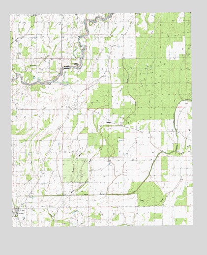
Baskinton, LA USGS Topographic Map
Click on map above to begin viewing in our Map Viewer.

This topographic map contains these locations and features:
Feature Name Type Latitude Longitude GNIS ID View Map
Archibald - Alto Fire StationBuildingN32.3626°W91.7118°2673050View Map
BaskinPopulated PlaceN32.2590°W91.7476°542957View Map
Baskin ChapelChurchN32.3199°W91.7426°532325View Map
Baskin Post OfficePost OfficeN32.2569°W91.7459°1630062View Map
Baskin SchoolSchoolN32.2617°W91.7449°544072View Map
Baskin Volunteer Fire DepartmentBuildingN32.2630°W91.7435°2673088View Map
BaskintonPopulated PlaceN32.3113°W91.6807°542958View Map
Baskinton Oil FieldOilfieldN32.3429°W91.6418°544073View Map
Bethel ChurchChurchN32.2757°W91.6973°532977View Map
Brushy BayouStreamN32.2688°W91.7098°533457View Map
Bulls BayouGutN32.2735°W91.7023°533543View Map
Church of ChristChurchN32.3493°W91.7323°541259View Map
Friendship CemeteryCemeteryN32.3560°W91.6796°544089View Map
Friendship ChurchChurchN32.3563°W91.6798°535121View Map
Greg's Flying ServiceAirportN32.2684°W91.6982°2676741View Map
Hurricane BayouStreamN32.3401°W91.7462°535869View Map
Oliair AirportAirportN32.2537°W91.7206°2770258View Map
Parish Governing Authority District 6CivilN32.2863°W91.6936°1930134View Map
Pine CreekStreamN32.2618°W91.7482°538162View Map
Pleasant Hall Baptist ChurchChurchN32.3049°W91.6596°555679View Map
Pleasant Hall CemeteryCemeteryN32.3049°W91.6598°544098View Map
Rowing BayouStreamN32.2938°W91.6371°538757View Map
South Baskinton Oil FieldOilfieldN32.3115°W91.6737°544101View Map
South Big Creek Oil FieldOilfieldN32.3632°W91.6779°539483View Map
Turkey Creek Cut-OffBendN32.2685°W91.6896°540036View Map
Union CemeteryCemeteryN32.3188°W91.7090°544103View Map
Union ChurchChurchN32.3679°W91.6671°540097View Map
Union ChurchChurchN32.3193°W91.7090°556295View Map
Union Valley ChurchChurchN32.3168°W91.6901°540112View Map
Village of BaskinCivilN32.2591°W91.7473°2407415View Map
Ward SixCivilN32.2915°W91.7076°545031View Map
West Baskinton Oil FieldOilfieldN32.3168°W91.6954°544105View Map

Note: Coordinates in the location and feature list above are referenced to NAD83 datum.


Copyright (C) 2008-2024 Ryan Niemi / Sunset Dynamics ... All Rights Reserved