TopoQuest Logo
Do you find TopoQuest useful?
Help keep TopoQuest running and adding new maps/features by donating!
Bitcoin:  19c7KJd3qBynnjoSw5npx9KScwjBe4ifkT
Litecoin:  LXs6TkuXGGXo1vDsWCkWVdjQX94eUKd6ui
Home View Maps Find Maps Find Places Resources & Links


Morganza, Louisiana Topographic Map

USGS Map Title: Morganza, LA
USGS Map MRC: 30091F5
DRG (GeoTIFF) Download: o30091f5.tif


Neighboring USGS Topographic Map Quads:


  Batchelor, LA  
30091G6
 

  Lacour, LA  
30091G5
 

  Saint Francisville, LA  
30091G4
 

  Melville, LA  
30091F6
 

  Morganza, LA  
30091F5
 

  New Roads, LA  
30091F4
 

  Lottie, LA  
30091E6
 

  Fordoche, LA  
30091E5
 

  Erwinville, LA  
30091E4


Map MRC Location:

N31°
W92°
N31°
W91°
H8 H7 H6 H5 H4 H3 H2 H1
G8 G7 G6 G5 G4 G3 G2 G1
F8 F7 F6 F5 F4 F3 F2 F1
E8 E7 E6 E5 E4 E3 E2 E1
D8 D7 D6 D5 D4 D3 D2 D1
C8 C7 C6 C5 C4 C3 C2 C1
B8 B7 B6 B5 B4 B3 B2 B1
A8 A7 A6 A5 A4 A3 A2 A1
N30°
W92°
N30°
W91°

Morganza, LA USGS 1:24K Topographic Map Preview:
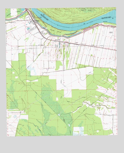
Morganza, LA USGS Topographic Map
Click on map above to begin viewing in our Map Viewer.

This topographic map contains these locations and features:
Feature Name Type Latitude Longitude GNIS ID View Map
Angeles PlantationPopulated PlaceN30.7221°W91.5193°2612056View Map
Bayou BarreStreamN30.6744°W91.5976°553412View Map
Bayou LeskineStreamN30.6569°W91.5648°553482View Map
Bethel Baptist Worship CenterChurchN30.7383°W91.5935°2601389View Map
Boies PointCapeN30.7357°W91.5129°533305View Map
Boies Point RevetmentLeveeN30.7335°W91.5259°542150View Map
Bright Morning Star CemeteryCemeteryN30.7357°W91.6190°549434View Map
Bright Morning Star ChurchChurchN30.7363°W91.6196°533401View Map
BrownviewPopulated PlaceN30.7269°W91.5859°533443View Map
Brunswick PlantationPopulated PlaceN30.7230°W91.5307°542151View Map
Buckhorn BayouStreamN30.6460°W91.5651°553246View Map
Dawson SwitchPopulated PlaceN30.7182°W91.5701°554195View Map
Frederick SpurLocaleN30.7085°W91.5068°542154View Map
George SpurLocaleN30.7091°W91.5093°542155View Map
Judge Digby Gas FieldOilfieldN30.6319°W91.5112°546232View Map
KelseyPopulated PlaceN30.7107°W91.5179°542157View Map
LabarrePopulated PlaceN30.7146°W91.5457°543370View Map
Labarre Elementary SchoolSchoolN30.7144°W91.5382°1629686View Map
Labarre Post OfficePost OfficeN30.7146°W91.5446°1630531View Map
Louisiana Noname 47 DamDamN30.7302°W91.6001°556891View Map
Moore-Sams Oil FieldOilfieldN30.6821°W91.5065°546242View Map
Morgans BendBendN30.7477°W91.5918°542158View Map
MorganzaPopulated PlaceN30.7385°W91.5943°537212View Map
Morganza CrevasseBasinN30.7271°W91.5695°537213View Map
Morganza Elementary School (historical)SchoolN30.7310°W91.5959°546243View Map
Morganza High SchoolSchoolN30.7316°W91.5907°546245View Map
Morganza LandingPopulated PlaceN30.7410°W91.5879°543487View Map
Morganza Police DepartmentBuildingN30.7370°W91.5938°2333996View Map
Morganza RevetmentLeveeN30.7460°W91.5929°542159View Map
Morganza Volunteer Fire DepartmentBuildingN30.7366°W91.5921°2691640View Map
Morning Star ChurchChurchN30.7305°W91.5021°537222View Map
Morning Star ChurchChurchN30.7305°W91.5021°542160View Map
MorrisonPopulated PlaceN30.7127°W91.5287°543488View Map
Mount Airy CemeteryCemeteryN30.7141°W91.5843°549453View Map
Mount Airy ChurchChurchN30.7141°W91.5848°537284View Map
New Roads Police Department - Maintenance ShopBuildingN30.7090°W91.5118°2333987View Map
Pointe Coupee Central High SchoolSchoolN30.7174°W91.5370°2493411View Map
Pointe Coupee ParishCivilN30.7094°W91.6008°559449View Map
Pointe Coupee Parish Library Morganza BranchBuildingN30.7366°W91.5921°2603117View Map
Portage CanalCanalN30.6577°W91.5257°538348View Map
Portage Canal Number TwoCanalN30.6855°W91.5843°538350View Map
Saint Anns Catholic ChurchChurchN30.7357°W91.5946°546264View Map
SamuelsPopulated PlaceN30.7141°W91.5401°542164View Map
Sixth Ward ChurchChurchN30.7296°W91.5259°539409View Map
Stewart PlantationPopulated PlaceN30.7210°W91.5332°542165View Map
Stonewell PlantationPopulated PlaceN30.7255°W91.5040°543705View Map
Village of MorganzaCivilN30.7383°W91.5920°2407506View Map
Ward FiveCivilN30.6985°W91.5032°545162View Map
Ward FourCivilN30.7191°W91.6168°545161View Map
Wilbert School (historical)SchoolN30.7305°W91.5018°542166View Map
Zugg (historical)Populated PlaceN30.6482°W91.6093°546281View Map

Note: Coordinates in the location and feature list above are referenced to NAD83 datum.


Copyright (C) 2008-2024 Ryan Niemi / Sunset Dynamics ... All Rights Reserved