TopoQuest Logo
Do you find TopoQuest useful?
Help keep TopoQuest running and adding new maps/features by donating!
Bitcoin:  19c7KJd3qBynnjoSw5npx9KScwjBe4ifkT
Litecoin:  LXs6TkuXGGXo1vDsWCkWVdjQX94eUKd6ui
Home View Maps Find Maps Find Places Resources & Links


Morven East, North Carolina Topographic Map

USGS Map Title: Morven East, NC
USGS Map MRC: 34079G8
DRG (GeoTIFF) Download: o34079g8.tif


Neighboring USGS Topographic Map Quads:


  Wadesboro, NC  
34080H1
 

  Lilesville, NC  
34079H8
 

  Rockingham, NC  
34079H7
 

  Morven West, NC  
34080G1
 

  Morven East, NC  
34079G8
 

  Diggs, NC  
34079G7
 

  Chesterfield, SC  
34080F1
 

  Cheraw, SC  
34079F8
 

  Wallace, SC  
34079F7


Map MRC Location:

N35°
W80°
N35°
W79°
H8 H7 H6 H5 H4 H3 H2 H1
G8 G7 G6 G5 G4 G3 G2 G1
F8 F7 F6 F5 F4 F3 F2 F1
E8 E7 E6 E5 E4 E3 E2 E1
D8 D7 D6 D5 D4 D3 D2 D1
C8 C7 C6 C5 C4 C3 C2 C1
B8 B7 B6 B5 B4 B3 B2 B1
A8 A7 A6 A5 A4 A3 A2 A1
N34°
W80°
N34°
W79°

Morven East, NC USGS 1:24K Topographic Map Preview:
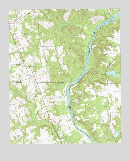
Morven East, NC USGS Topographic Map
Click on map above to begin viewing in our Map Viewer.

This topographic map contains these locations and features:
Feature Name Type Latitude Longitude GNIS ID View Map
Bethel ChurchChurchN34.7843°W79.8903°1220573View Map
Britts School (historical)SchoolN34.7924°W79.9623°1235600View Map
Brocks MillPopulated PlaceN34.7574°W79.9951°1220981View Map
Brocks Mill Baptist ChurchChurchN34.7585°W79.9917°1235601View Map
Brocks Mill CemeteryCemeteryN34.7584°W79.9921°1248728View Map
Brocks Mill Fire Department Station 1BuildingN34.7588°W79.9891°2578270View Map
Everett Lake DamDamN34.8154°W79.8912°998134View Map
Everetts LakeReservoirN34.8146°W79.8837°984871View Map
Everetts MillPopulated PlaceN34.8143°W79.8920°1020182View Map
Galilee ChurchChurchN34.8263°W79.9873°985524View Map
Goodmans CreekStreamN34.7518°W79.9178°1222763View Map
Gordons FallsFallsN34.7510°W79.9026°1235667View Map
Horse IslandIslandN34.7521°W79.9062°1235779View Map
Jones CreekStreamN34.8621°W79.8942°987747View Map
Laneys (historical)Populated PlaceN34.7538°W79.9484°1235692View Map
Little CreekStreamN34.8679°W79.8839°988598View Map
Little Westfield CreekStreamN34.7729°W79.9740°1224072View Map
Marks CreekStreamN34.7929°W79.9323°989345View Map
McFarlanPopulated PlaceN34.8124°W79.9759°1021390View Map
McFarlan Post OfficePost OfficeN34.8110°W79.9703°2774312View Map
Mill CreekStreamN34.8507°W79.9056°989959View Map
Morven Volunteer Fire DepartmentBuildingN34.8635°W79.9983°2639146View Map
Mount Zion ChurchChurchN34.7974°W79.9645°1249732View Map
Mount Zion School (historical)SchoolN34.7977°W79.9645°1235726View Map
Nelson LakeReservoirN34.8176°W79.9605°998140View Map
Nelson Lake DamDamN34.8185°W79.9615°998141View Map
New Hope ChurchChurchN34.8040°W79.8906°1249832View Map
New Hope School (historical)SchoolN34.7938°W79.8898°1232773View Map
Old SneedsboroPopulated PlaceN34.8327°W79.9362°1021738View Map
Parkers Ferry (historical)CrossingN34.8065°W79.9287°1232776View Map
Paul Wallace PondReservoirN34.7580°W79.8804°1238507View Map
Peagues Mill (historical)LocaleN34.7671°W79.9512°1235744View Map
Phillips Pond Dam D-3215DamN34.7935°W79.9415°1239975View Map
Pine Forest LakeReservoirN34.8527°W79.9836°992235View Map
Pleasant Hill CemeteryCemeteryN34.8163°W79.9726°992511View Map
Pusser PondReservoirN34.7702°W79.9031°1240260View Map
Pusser Pond Dam D-3425DamN34.7702°W79.9031°1240259View Map
Ramah Grove ChurchChurchN34.8240°W79.9901°993009View Map
South Carolina Noname 35015 Dam D-3427DamN34.7552°W79.8831°1238506View Map
Stag RockIslandN34.8065°W79.9287°1232799View Map
Town of McFarlanCivilN34.8148°W79.9766°2406130View Map
Township of MorvenCivilN34.8606°W79.9730°1026376View Map
Whortleberry CreekStreamN34.8071°W79.9306°997282View Map

Note: Coordinates in the location and feature list above are referenced to NAD83 datum.


Copyright (C) 2008-2025 Ryan Niemi / Sunset Dynamics ... All Rights Reserved