TopoQuest Logo
Do you find TopoQuest useful?
Help keep TopoQuest running and adding new maps/features by donating!
Bitcoin:  19c7KJd3qBynnjoSw5npx9KScwjBe4ifkT
Litecoin:  LXs6TkuXGGXo1vDsWCkWVdjQX94eUKd6ui
Home View Maps Find Maps Find Places Resources & Links


Rockingham, North Carolina Topographic Map

USGS Map Title: Rockingham, NC
USGS Map MRC: 34079H7
DRG (GeoTIFF) Download: o34079h7.tif


Neighboring USGS Topographic Map Quads:


  Mangum, NC  
35079A8
 

  Ellerbe, NC  
35079A7
 

  Millstone Lake, NC  
35079A6
 

  Lilesville, NC  
34079H8
 

  Rockingham, NC  
34079H7
 

  Hamlet, NC  
34079H6
 

  Morven East, NC  
34079G8
 

  Diggs, NC  
34079G7
 

  Ghio, NC  
34079G6


Map MRC Location:

N35°
W80°
N35°
W79°
H8 H7 H6 H5 H4 H3 H2 H1
G8 G7 G6 G5 G4 G3 G2 G1
F8 F7 F6 F5 F4 F3 F2 F1
E8 E7 E6 E5 E4 E3 E2 E1
D8 D7 D6 D5 D4 D3 D2 D1
C8 C7 C6 C5 C4 C3 C2 C1
B8 B7 B6 B5 B4 B3 B2 B1
A8 A7 A6 A5 A4 A3 A2 A1
N34°
W80°
N34°
W79°

Rockingham, NC USGS 1:24K Topographic Map Preview:
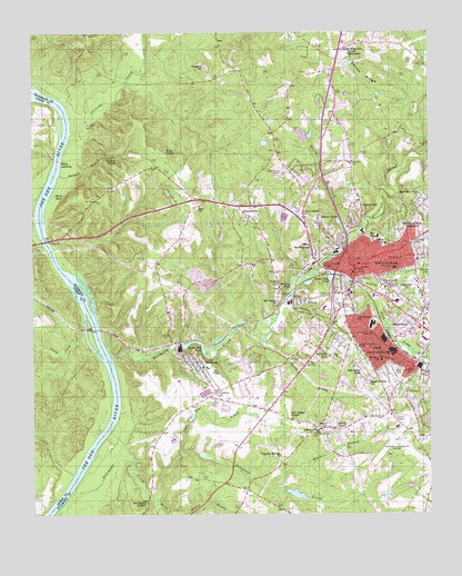
Rockingham, NC USGS Topographic Map
Click on map above to begin viewing in our Map Viewer.

This topographic map contains these locations and features:
Feature Name Type Latitude Longitude GNIS ID View Map
Aleo ChurchChurchN34.9218°W79.7712°980086View Map
Ashley ChapelChurchN34.8968°W79.7784°980328View Map
Ashley Chapel SchoolSchoolN34.8971°W79.7845°980331View Map
Baggetts CreekStreamN34.8779°W79.8359°980421View Map
Bell SchoolSchoolN34.9471°W79.7662°980946View Map
Black BranchStreamN34.8818°W79.8012°981513View Map
Black PondLakeN34.9575°W79.8680°981537View Map
Bunker HillPopulated PlaceN34.9549°W79.7712°1019405View Map
Cape Fear BranchStreamN34.8915°W79.8287°982619View Map
Cartledge CreekStreamN34.9727°W79.8634°982700View Map
City of RockinghamCivilN34.9386°W79.7608°2404637View Map
Cobb ChurchChurchN34.9121°W79.7573°983315View Map
Coggins HillSummitN34.9910°W79.8206°1019717View Map
CordovaPopulated PlaceN34.9129°W79.8220°983544View Map
Cordova Census Designated PlaceCensusN34.9102°W79.8119°2584312View Map
Cordova ChurchChurchN34.9071°W79.8170°983545View Map
Cordova Elementary SchoolSchoolN34.9132°W79.8201°1006774View Map
Cordova Fire and RescueBuildingN34.9133°W79.8215°2720360View Map
Cordova Post OfficePost OfficeN34.9130°W79.8220°2774145View Map
East RockinghamPopulated PlaceN34.9182°W79.7626°1020089View Map
East Rockingham Census Designated PlaceCensusN34.9115°W79.7660°2402435View Map
East Rockingham Fire DepartmentBuildingN34.9076°W79.7641°2639437View Map
East Side CemeteryCemeteryN34.9457°W79.7531°984535View Map
East Side ParkPopulated PlaceN34.9568°W79.7501°1020092View Map
Falling CreekStreamN34.9379°W79.7851°984983View Map
Falls Ferry (historical)LocaleN34.9432°W79.8687°1002143View Map
Five PointsPopulated PlaceN34.9527°W79.7895°985133View Map
GlenwoodPopulated PlaceN34.9321°W79.7584°1020451View Map
Great Falls PondReservoirN34.9365°W79.7809°986014View Map
Great Falls SchoolSchoolN34.9393°W79.7828°986015View Map
Hitchcock CreekStreamN34.9157°W79.8501°986855View Map
Honey TownPopulated PlaceN34.9502°W79.7837°987015View Map
Island CreekStreamN34.9227°W79.8584°987422View Map
Jefferson ParkPopulated PlaceN34.9179°W79.7851°987543View Map
Jennies BranchStreamN34.9277°W79.7973°987564View Map
Leak Street Elementary SchoolSchoolN34.9388°W79.7609°1006771View Map
Maple Street ChurchChurchN34.9096°W79.7687°989318View Map
MaplewoodPopulated PlaceN34.9246°W79.7539°1021344View Map
McCoy CreekStreamN34.9507°W79.8739°989548View Map
MidwayPopulated PlaceN34.9307°W79.7892°1021440View Map
Midway PondReservoirN34.9307°W79.7948°989836View Map
Mispah CemeteryCemeteryN34.8982°W79.7814°990078View Map
Mount Beaula ChurchChurchN34.9299°W79.7976°990314View Map
New Diggs ChapelChurchN34.9004°W79.7939°990958View Map
Northan CemeteryCemeteryN34.9671°W79.7737°991283View Map
Oak Ridge ParkPopulated PlaceN34.9138°W79.7731°1021703View Map
Old Diggs ChapelChurchN34.8779°W79.8395°991542View Map
Pee Dee SchoolSchoolN34.9482°W79.7787°992003View Map
Pine Grove ChurchChurchN34.9188°W79.7717°992239View Map
Piney GrovePopulated PlaceN34.9552°W79.8103°992332View Map
Popular Springs CemeteryCemeteryN34.8954°W79.7876°992716View Map
Popular Springs ChurchChurchN34.8904°W79.7973°992717View Map
Richmond County AirportAirportN34.8941°W79.7577°997867View Map
Richmond County MineMineN34.9992°W79.7797°2649273View Map
Richmond County Rescue SquadBuildingN34.9290°W79.7571°2720373View Map
Richmond County Sheriff's OfficeBuildingN34.9377°W79.7739°2769816View Map
Richmond Park ExtensionPopulated PlaceN34.9521°W79.7542°1022283View Map
RockinghamPopulated PlaceN34.9393°W79.7739°993546View Map
Rockingham Fire Department Station 1 HeadquartersBuildingN34.9370°W79.7719°2638240View Map
Rockingham Junior High SchoolSchoolN34.9452°W79.7634°1006772View Map
Rockingham Police DepartmentBuildingN34.9386°W79.7716°2769606View Map
Rockingham Post OfficePost OfficeN34.9385°W79.7766°2774275View Map
Rockingham QuarryMineN34.9322°W79.8192°2649274View Map
Rocky BranchStreamN34.9196°W79.8028°993556View Map
Rohanen SchoolSchoolN34.9149°W79.7651°993652View Map
Sandy Ridge SchoolSchoolN34.9957°W79.7770°994323View Map
Seaburn BranchStreamN34.9635°W79.8662°994453View Map
Seaburn SpringSpringN34.9676°W79.8485°994454View Map
Solomons CreekStreamN34.8752°W79.8676°995104View Map
South Prong Falling CreekStreamN34.9340°W79.7717°995196View Map
Speeds CreekStreamN34.8793°W79.8376°995278View Map
Steele Millpond DamDamN34.9196°W79.8289°998207View Map
Steeles Mill PondReservoirN34.9196°W79.8289°995449View Map
Steely BranchStreamN34.9474°W79.7759°995452View Map
Stelley TabernacleChurchN34.9946°W79.7751°995462View Map
Township of RockinghamCivilN34.9668°W79.7811°1027098View Map
Walls ChapelChurchN34.9693°W79.8331°996728View Map
Walls LandingPopulated PlaceN34.9674°W79.8651°1023107View Map
Watery BranchStreamN34.8752°W79.8264°996856View Map
West RockinghamPopulated PlaceN34.9432°W79.7870°1023178View Map
West Rockingham Elementary SchoolSchoolN34.9452°W79.7889°1006773View Map
WLWL-AM (Rockingham)TowerN34.9252°W79.7862°1018381View Map
Yates HillPopulated PlaceN34.9349°W79.7976°1023337View Map
Zion ChurchChurchN34.9554°W79.8226°997759View Map

Note: Coordinates in the location and feature list above are referenced to NAD83 datum.


Copyright (C) 2008-2025 Ryan Niemi / Sunset Dynamics ... All Rights Reserved