TopoQuest Logo
Do you find TopoQuest useful?
Help keep TopoQuest running and adding new maps/features by donating!
Bitcoin:  19c7KJd3qBynnjoSw5npx9KScwjBe4ifkT
Litecoin:  LXs6TkuXGGXo1vDsWCkWVdjQX94eUKd6ui
Home View Maps Find Maps Find Places Resources & Links


Wadesboro, North Carolina Topographic Map

USGS Map Title: Wadesboro, NC
USGS Map MRC: 34080H1
DRG (GeoTIFF) Download: o34080h1.tif


Neighboring USGS Topographic Map Quads:


  Polkton, NC  
35080A2
 

  Ansonville, NC  
35080A1
 

  Mangum, NC  
35079A8
 

  Russellville, NC  
34080H2
 

  Wadesboro, NC  
34080H1
 

  Lilesville, NC  
34079H8
 

  Mount Croghan, SC  
34080G2
 

  Morven West, NC  
34080G1
 

  Morven East, NC  
34079G8


Map MRC Location:

N35°
W81°
N35°
W80°
H8 H7 H6 H5 H4 H3 H2 H1
G8 G7 G6 G5 G4 G3 G2 G1
F8 F7 F6 F5 F4 F3 F2 F1
E8 E7 E6 E5 E4 E3 E2 E1
D8 D7 D6 D5 D4 D3 D2 D1
C8 C7 C6 C5 C4 C3 C2 C1
B8 B7 B6 B5 B4 B3 B2 B1
A8 A7 A6 A5 A4 A3 A2 A1
N34°
W81°
N34°
W80°

Wadesboro, NC USGS 1:24K Topographic Map Preview:
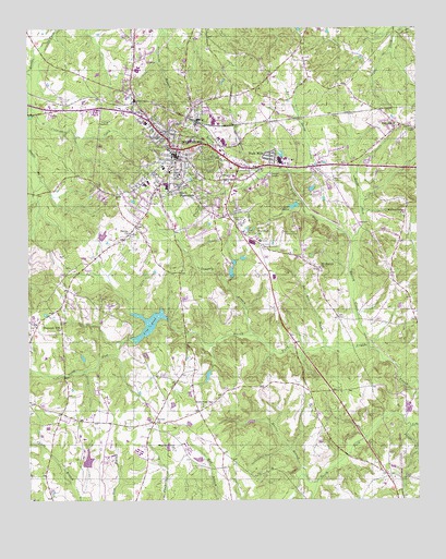
Wadesboro, NC USGS Topographic Map
Click on map above to begin viewing in our Map Viewer.

This topographic map contains these locations and features:
Feature Name Type Latitude Longitude GNIS ID View Map
Anson CountyCivilN34.9738°W80.1027°1008534View Map
Anson County Sheriff's OfficeBuildingN34.9670°W80.0758°2769792View Map
Anson Emergency Medical ServicesBuildingN34.9709°W80.0682°2720556View Map
Anson Middle SchoolSchoolN34.9746°W80.0870°1002147View Map
Anson Rescue SquadBuildingN34.9648°W80.0747°2720677View Map
Bailey CreekStreamN34.9157°W80.0159°980427View Map
Bennett CemeteryCemeteryN34.9599°W80.0266°980994View Map
Bethel ChurchChurchN34.8954°W80.0845°981113View Map
Bowman High SchoolSchoolN34.9710°W80.0903°1002148View Map
Brush ForkStreamN34.9438°W80.0206°1023481View Map
Carolinas HealthCare System AnsonHospitalN34.9777°W80.1100°1024910View Map
Central SchoolSchoolN34.9621°W80.0795°1002149View Map
City PondReservoirN34.9232°W80.0803°983202View Map
City Pond DamDamN34.9233°W80.0804°998212View Map
Culpepper CreekStreamN34.9799°W80.1237°983837View Map
Derita CreekStreamN34.9624°W80.0409°984138View Map
East View CemeteryCemeteryN34.9621°W80.0701°984544View Map
Flat Rock ChurchChurchN34.9465°W80.0514°985180View Map
Flat Rock Church CemeteryCemeteryN34.9467°W80.0513°2779002View Map
Gatewood Station ChurchChurchN34.8999°W80.0690°985611View Map
Hanna ChurchChurchN34.9460°W80.0926°986372View Map
Hanna Church CemeteryCemeteryN34.9462°W80.0923°2778986View Map
Hightower Areo Plantation AirportAirportN34.9683°W80.0280°2679275View Map
J R Faison SchoolSchoolN34.9632°W80.0812°1002150View Map
Lake MareeReservoirN34.9530°W80.0392°998229View Map
Lake Maree DamDamN34.9537°W80.0382°998228View Map
Lampley BranchStreamN34.9185°W80.0520°988120View Map
Madison Grove ChurchChurchN34.8882°W80.0778°989223View Map
Moore LakeReservoirN34.9354°W80.0596°998221View Map
Moore Lake DamDamN34.9343°W80.0595°998220View Map
Morris BranchStreamN34.8815°W80.0376°990259View Map
Mount Beaulah Church CemeteryCemeteryN34.9360°W80.0307°2779001View Map
Mount Beulah ChurchChurchN34.9368°W80.0312°990325View Map
Nelson LakeReservoirN34.9081°W80.0673°998200View Map
Nelson Lake DamDamN34.9085°W80.0664°998201View Map
North Fork Jones CreekStreamN34.8940°W80.0023°991223View Map
Paris (historical)Populated PlaceN34.9207°W80.0206°1002151View Map
Parson Grove ChurchChurchN34.9507°W80.0034°991897View Map
Piedmont Medical Center HeliportAirportN34.9557°W80.0581°1251957View Map
Pine Grove ChurchChurchN34.9740°W80.0062°992240View Map
Plank Road Shopping CenterLocaleN34.9657°W80.0623°1024911View Map
Pleasant Hill ChurchChurchN34.9204°W80.1145°992517View Map
Pleasant Hill Church CemeteryCemeteryN34.9193°W80.1157°2778987View Map
Red River BranchStreamN34.9152°W80.0281°993132View Map
Reedy ForkStreamN34.9440°W80.0203°993200View Map
South Fork Jones CreekStreamN34.8940°W80.0026°995153View Map
South WadesboroPopulated PlaceN34.9563°W80.0773°995221View Map
Town of WadesboroCivilN34.9646°W80.0747°2406812View Map
Township of WadesboroCivilN34.9854°W80.0924°1026377View Map
Twin Valley Country ClubLocaleN34.9463°W80.0431°996389View Map
Wade MillsPopulated PlaceN34.9657°W80.0470°1023089View Map
WADE-AM (Wadesboro)TowerN34.9504°W80.0562°1018382View Map
WadesboroPopulated PlaceN34.9682°W80.0767°996663View Map
Wadesboro Fire DepartmentBuildingN34.9659°W80.0754°2638774View Map
Wadesboro Municipal LakeReservoirN34.9218°W80.0862°998211View Map
Wadesboro Police DepartmentBuildingN34.9657°W80.0755°2769925View Map
Wadesboro Post OfficePost OfficeN34.9675°W80.0763°2774374View Map
Wadesboro SchoolSchoolN34.9515°W80.0609°1002152View Map

Note: Coordinates in the location and feature list above are referenced to NAD83 datum.


Copyright (C) 2008-2024 Ryan Niemi / Sunset Dynamics ... All Rights Reserved