TopoQuest Logo
Do you find TopoQuest useful?
Help keep TopoQuest running and adding new maps/features by donating!
Bitcoin:  19c7KJd3qBynnjoSw5npx9KScwjBe4ifkT
Litecoin:  LXs6TkuXGGXo1vDsWCkWVdjQX94eUKd6ui
Home View Maps Find Maps Find Places Resources & Links


Morven West, North Carolina Topographic Map

USGS Map Title: Morven West, NC
USGS Map MRC: 34080G1
DRG (GeoTIFF) Download: o34080g1.tif


Neighboring USGS Topographic Map Quads:


  Russellville, NC  
34080H2
 

  Wadesboro, NC  
34080H1
 

  Lilesville, NC  
34079H8
 

  Mount Croghan, SC  
34080G2
 

  Morven West, NC  
34080G1
 

  Morven East, NC  
34079G8
 

  Ruby, SC  
34080F2
 

  Chesterfield, SC  
34080F1
 

  Cheraw, SC  
34079F8


Map MRC Location:

N35°
W81°
N35°
W80°
H8 H7 H6 H5 H4 H3 H2 H1
G8 G7 G6 G5 G4 G3 G2 G1
F8 F7 F6 F5 F4 F3 F2 F1
E8 E7 E6 E5 E4 E3 E2 E1
D8 D7 D6 D5 D4 D3 D2 D1
C8 C7 C6 C5 C4 C3 C2 C1
B8 B7 B6 B5 B4 B3 B2 B1
A8 A7 A6 A5 A4 A3 A2 A1
N34°
W81°
N34°
W80°

Morven West, NC USGS 1:24K Topographic Map Preview:
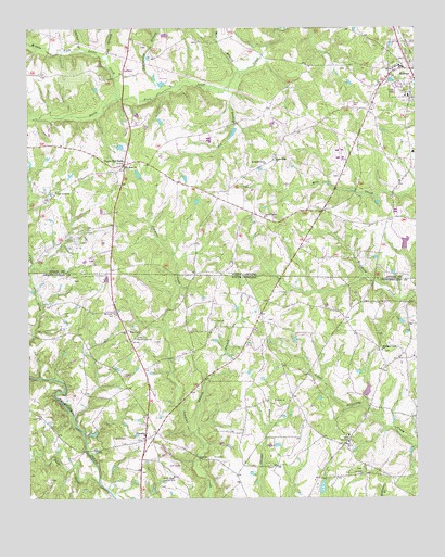
Morven West, NC USGS Topographic Map
Click on map above to begin viewing in our Map Viewer.

This topographic map contains these locations and features:
Feature Name Type Latitude Longitude GNIS ID View Map
Big BranchStreamN34.8593°W80.0601°981324View Map
Brocks Mill Fire Department Station 3BuildingN34.7874°W80.0036°2578724View Map
Cason Old FieldPopulated PlaceN34.8385°W80.0940°982731View Map
Childs BranchStreamN34.8688°W80.1056°983135View Map
Cosa Pentecostal ChurchChurchN34.8024°W80.0117°1235635View Map
Crawford LakeReservoirN34.8471°W80.0586°998155View Map
Crawford Lake DamDamN34.8485°W80.0581°998154View Map
David Grove Baptist ChurchChurchN34.7929°W80.0903°1247495View Map
Davids Grove CemeteryCemeteryN34.7932°W80.0900°1248731View Map
Deep CreekStreamN34.7540°W80.1020°1247514View Map
Featherbed BranchStreamN34.8593°W80.0781°985023View Map
Friendship ChurchChurchN34.7663°W80.0878°1247843View Map
Friendship Church GraveyardCemeteryN34.7658°W80.0881°1235663View Map
Green River Country ClubLocaleN34.7560°W80.0784°1242397View Map
Gum BranchStreamN34.8660°W80.1003°986211View Map
Jones Creek (historical)Populated PlaceN34.8577°W80.0940°1002140View Map
Little Cedar CreekStreamN34.7718°W80.1103°1235696View Map
McClain Grove Baptist ChurchChurchN34.7877°W80.0009°1235706View Map
McLain Grove School (historical)SchoolN34.7871°W80.0028°1235707View Map
McRae SchoolSchoolN34.8571°W80.0020°1002141View Map
Middle Fork Jones CreekStreamN34.8563°W80.0942°989776View Map
Mill BranchStreamN34.8635°W80.0565°989884View Map
Moran McLendon PondReservoirN34.8185°W80.0098°998143View Map
Moran McLendon Pond DamDamN34.8185°W80.0098°998142View Map
MorvenPopulated PlaceN34.8640°W80.0012°1021540View Map
Morven Post OfficePost OfficeN34.8637°W80.0006°2774213View Map
Morven SchoolSchoolN34.8646°W80.0045°1002142View Map
Mount Level Baptist ChurchChurchN34.7993°W80.0967°1249599View Map
New Hope ChurchChurchN34.8385°W80.0940°990993View Map
Oak Grove ChurchChurchN34.8315°W80.1153°991362View Map
Pleasant Grove CemeteryCemeteryN34.7583°W80.0180°1248741View Map
Pleasant Grove ChurchChurchN34.7582°W80.0176°1225537View Map
Pleasant Grove School (historical)SchoolN34.7579°W80.0173°1235752View Map
Sandy Plains ChurchChurchN34.8249°W80.0487°994295View Map
Sandy Ridge ChurchChurchN34.8407°W80.0448°994314View Map
Smarsh BranchStreamN34.7674°W80.0709°1226680View Map
Snow Hill Church (historical)ChurchN34.7946°W80.0256°1235773View Map
Snow Hill School (historical)SchoolN34.7946°W80.0251°1235774View Map
Streaters Grove ChurchChurchN34.8393°W80.0481°995611View Map
Teals Pond Dam D-3203DamN34.7518°W80.0298°1239986View Map
Town of MorvenCivilN34.8643°W80.0000°2406199View Map
Township of GulledgeCivilN34.8670°W80.1103°1026373View Map
Vaughn School (historical)SchoolN34.7868°W80.0965°1235791View Map
Westfield Creek Baptist ChurchChurchN34.7893°W80.0112°1251396View Map
Westfield Creek CemeteryCemeteryN34.7892°W80.0106°1248747View Map
Zoar CemeteryCemeteryN34.7649°W80.0215°1248750View Map
Zoar ChurchChurchN34.7649°W80.0220°1251566View Map
Zoar School (historical)SchoolN34.7654°W80.0226°1235811View Map

Note: Coordinates in the location and feature list above are referenced to NAD83 datum.


Copyright (C) 2008-2025 Ryan Niemi / Sunset Dynamics ... All Rights Reserved