TopoQuest Logo
Do you find TopoQuest useful?
Help keep TopoQuest running and adding new maps/features by donating!
Bitcoin:  19c7KJd3qBynnjoSw5npx9KScwjBe4ifkT
Litecoin:  LXs6TkuXGGXo1vDsWCkWVdjQX94eUKd6ui
Home View Maps Find Maps Find Places Resources & Links


Moscow East, Idaho Topographic Map

USGS Map Title: Moscow East, ID
USGS Map MRC: 46116F8
DRG (GeoTIFF) Download: o46116f8.tif


Neighboring USGS Topographic Map Quads:


  Viola, ID  
46117G1
 

  Robinson Lake, ID  
46116G8
 

  Moscow Mountain, ID  
46116G7
 

  Moscow West, ID  
46117F1
 

  Moscow East, ID  
46116F8
 

  Troy, ID  
46116F7
 

  Uniontown, WA  
46117E1
 

  Genesee, ID  
46116E8
 

  Green Knob, ID  
46116E7


Map MRC Location:

N47°
W117°
N47°
W116°
H8 H7 H6 H5 H4 H3 H2 H1
G8 G7 G6 G5 G4 G3 G2 G1
F8 F7 F6 F5 F4 F3 F2 F1
E8 E7 E6 E5 E4 E3 E2 E1
D8 D7 D6 D5 D4 D3 D2 D1
C8 C7 C6 C5 C4 C3 C2 C1
B8 B7 B6 B5 B4 B3 B2 B1
A8 A7 A6 A5 A4 A3 A2 A1
N46°
W117°
N46°
W116°

Moscow East, ID USGS 1:24K Topographic Map Preview:
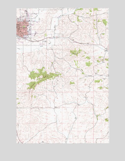
Moscow East, ID USGS Topographic Map
Click on map above to begin viewing in our Map Viewer.

This topographic map contains these locations and features:
Feature Name Type Latitude Longitude GNIS ID View Map
A B McDonald Elementary SchoolSchoolN46.7369°W116.9721°401292View Map
BlainePopulated PlaceN46.6571°W116.9488°376141View Map
Blaine CemeteryCemeteryN46.6585°W116.9474°2019049View Map
Buchanan CemeteryCemeteryN46.6849°W116.8796°371728View Map
Church of GodChurchN46.7283°W116.9983°2356848View Map
City of MoscowCivilN46.7306°W116.9990°2411172View Map
Cordelia Lutheran CemeteryCemeteryN46.6602°W116.8972°2019047View Map
Emmanuel Lutheran ChurchChurchN46.7333°W116.9961°2356840View Map
First Presbyterian ChurchChurchN46.7314°W116.9961°2356845View Map
First United Methodist ChurchChurchN46.7325°W116.9975°2356842View Map
Fountains AirportAirportN46.7132°W116.9974°400879View Map
Gnat CreekStreamN46.7454°W116.9313°382303View Map
Grace Baptist ChurchChurchN46.7339°W116.9878°2356844View Map
Haskins FlatFlatN46.7363°W116.9488°399073View Map
J Russell Elementary SchoolSchoolN46.7343°W116.9974°400677View Map
JoelPopulated PlaceN46.7104°W116.8779°396708View Map
KRFA-FM (Moscow)TowerN46.6816°W116.9713°401783View Map
KUID-TV (Moscow)TowerN46.6816°W116.9713°401814View Map
KZFN-FM (Moscow)TowerN46.6807°W116.9749°401784View Map
Latah County CourthouseBuildingN46.7306°W116.9967°2356846View Map
Latah County JailBuildingN46.7306°W116.9961°2356847View Map
Latah County Sheriff's OfficeBuildingN46.7308°W116.9967°2722420View Map
Lena Whitmore Elementary SchoolSchoolN46.7335°W116.9852°400708View Map
Moscow CemeteryCemeteryN46.7204°W116.9766°2746966View Map
Moscow DivisionCivilN46.7351°W116.9545°1936765View Map
Moscow Junior High SchoolSchoolN46.7383°W116.9826°394790View Map
Moscow MallLocaleN46.7213°W116.9846°394791View Map
Moscow Post OfficePost OfficeN46.7314°W116.9992°2356829View Map
Moscow Rural Fire DepartmentBuildingN46.7234°W116.9821°2618958View Map
Moscow Senior High SchoolSchoolN46.7316°W116.9967°401585View Map
Moscow Volunteer Fire Department Station 2BuildingN46.7236°W116.9823°2619178View Map
Moscow-Latah County LibraryBuildingN46.7331°W116.9983°2356841View Map
Our Saviors Lutheran ChurchChurchN46.7297°W116.9992°2356835View Map
Palouse Hills Chisitian SchoolSchoolN46.7197°W116.9628°401054View Map
Paradise RidgeRidgeN46.6777°W116.9768°374314View Map
Paradise ValleyValleyN46.7238°W116.9896°388192View Map
Paradise Wildlife Habitat AreaReserveN46.7071°W116.9404°401095View Map
Saint Marks Episcopal ChurchChurchN46.7333°W116.9992°2356830View Map
Saint Mary's SchoolSchoolN46.7369°W116.9908°374867View Map
Saint Marys Roman Catholic ChurchChurchN46.7339°W116.9936°2356843View Map
Saint Rose's Kindergarten CenterSchoolN46.7369°W116.9918°401149View Map
Sunset Memorial Gardens CemeteryCemeteryN46.7205°W116.9767°375355View Map
Tomer ButteSummitN46.7068°W116.9229°375550View Map

Note: Coordinates in the location and feature list above are referenced to NAD83 datum.


Copyright (C) 2008-2025 Ryan Niemi / Sunset Dynamics ... All Rights Reserved