TopoQuest Logo
Do you find TopoQuest useful?
Help keep TopoQuest running and adding new maps/features by donating!
Bitcoin:  19c7KJd3qBynnjoSw5npx9KScwjBe4ifkT
Litecoin:  LXs6TkuXGGXo1vDsWCkWVdjQX94eUKd6ui
Home View Maps Find Maps Find Places Resources & Links


Stewardson West, Illinois Topographic Map

USGS Map Title: Stewardson West, IL
USGS Map MRC: 39088C6
DRG (GeoTIFF) Download: o39088c6.tif


Neighboring USGS Topographic Map Quads:


  Shelbyville, IL  
39088D7
 

  Middlesworth, IL  
39088D6
 

  Windsor, IL  
39088D5
 

  Fancher, IL  
39088C7
 

  Stewardson West, IL  
39088C6
 

  Stewardson East, IL  
39088C5
 

  Beecher City, IL  
39088B7
 

  Shumway, IL  
39088B6
 

  Effingham North, IL  
39088B5


Map MRC Location:

N40°
W89°
N40°
W88°
H8 H7 H6 H5 H4 H3 H2 H1
G8 G7 G6 G5 G4 G3 G2 G1
F8 F7 F6 F5 F4 F3 F2 F1
E8 E7 E6 E5 E4 E3 E2 E1
D8 D7 D6 D5 D4 D3 D2 D1
C8 C7 C6 C5 C4 C3 C2 C1
B8 B7 B6 B5 B4 B3 B2 B1
A8 A7 A6 A5 A4 A3 A2 A1
N39°
W89°
N39°
W88°

Stewardson West, IL USGS 1:24K Topographic Map Preview:
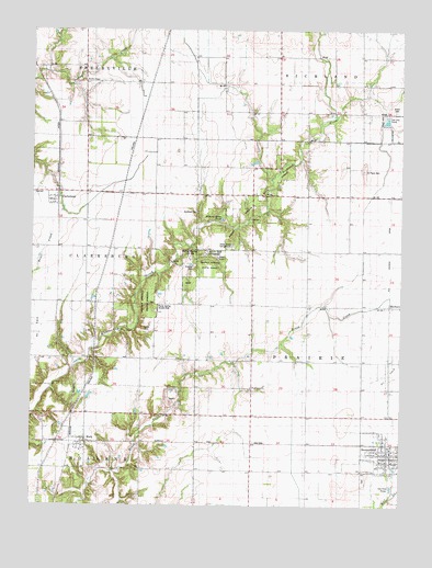
Stewardson West, IL USGS Topographic Map
Click on map above to begin viewing in our Map Viewer.

This topographic map contains these locations and features:
Feature Name Type Latitude Longitude GNIS ID View Map
Bass LakeReservoirN39.3617°W88.7401°1691843View Map
Bass Lake DamDamN39.3617°W88.7401°1691842View Map
Brush Creek QuarryMineN39.2778°W88.7039°1967387View Map
ClarksburgPopulated PlaceN39.3300°W88.7417°406176View Map
Clarksburg TownhallBuildingN39.3317°W88.7495°1725247View Map
East Salem School (historical)SchoolN39.3606°W88.7131°407692View Map
Grace CemeteryCemeteryN39.3542°W88.6270°409223View Map
Graybill CemeteryCemeteryN39.3128°W88.6956°1725263View Map
HerbornPopulated PlaceN39.3025°W88.6289°1725265View Map
Hickory Ridge PondReservoirN39.3253°W88.6862°1725266View Map
Hidden Springs State ForestForestN39.3187°W88.6901°1725267View Map
Holland School (historical)SchoolN39.2889°W88.7495°410392View Map
ModePopulated PlaceN39.2664°W88.7337°413695View Map
Mode Post OfficePost OfficeN39.2656°W88.7337°1821181View Map
Possum Creek CampgroundLocaleN39.3162°W88.6909°1725309View Map
Rockford CemeteryCemeteryN39.3270°W88.6942°1725316View Map
Rockford Church (historical)ChurchN39.3275°W88.6948°416844View Map
Rockford School (historical)SchoolN39.3323°W88.6762°416847View Map
Rocky Spring Access AreaParkN39.3020°W88.7076°1725317View Map
Rolling Meadows Use AreaParkN39.3148°W88.6964°1725318View Map
Saint Paul's CemeteryCemeteryN39.3384°W88.6381°417697View Map
Seventh Day Adventist ChurchChurchN39.2642°W88.6298°1967364View Map
Shady Grove CampgroundLocaleN39.3181°W88.6823°1725324View Map
StewardsonPopulated PlaceN39.2631°W88.6298°419122View Map
Stewardson CemeteryCemeteryN39.2561°W88.6372°419123View Map
Stewardson Fire and Ambulance Protection DistrictBuildingN39.2655°W88.6281°2681779View Map
Stewardson Post OfficePost OfficeN39.2636°W88.6281°2788812View Map
Stewardson United Methodist ChurchChurchN39.2620°W88.6298°1967365View Map
Township of PrairieCivilN39.2809°W88.6381°429597View Map
Union CemeteryCemeteryN39.2953°W88.7109°1725338View Map
Union Church (historical)ChurchN39.2953°W88.7095°420055View Map
Village of StewardsonCivilN39.2640°W88.6301°2399899View Map
Washington ChurchChurchN39.2820°W88.6759°420554View Map
Wesley ChapelChurchN39.3617°W88.7323°420767View Map
Whitlatch School (historical)SchoolN39.3709°W88.6664°421105View Map

Note: Coordinates in the location and feature list above are referenced to NAD83 datum.


Copyright (C) 2008-2025 Ryan Niemi / Sunset Dynamics ... All Rights Reserved