TopoQuest Logo
Do you find TopoQuest useful?
Help keep TopoQuest running and adding new maps/features by donating!
Bitcoin:  19c7KJd3qBynnjoSw5npx9KScwjBe4ifkT
Litecoin:  LXs6TkuXGGXo1vDsWCkWVdjQX94eUKd6ui
Home View Maps Find Maps Find Places Resources & Links


Polkton, North Carolina Topographic Map

USGS Map Title: Polkton, NC
USGS Map MRC: 35080A2
DRG (GeoTIFF) Download: o35080a2.tif


Neighboring USGS Topographic Map Quads:


  Oakboro, NC  
35080B3
 

  Aquadale, NC  
35080B2
 

  Mount Gilead West, NC  
35080B1
 

  Olive Branch, NC  
35080A3
 

  Polkton, NC  
35080A2
 

  Ansonville, NC  
35080A1
 

  Marshville, NC  
34080H3
 

  Russellville, NC  
34080H2
 

  Wadesboro, NC  
34080H1


Map MRC Location:

N36°
W81°
N36°
W80°
H8 H7 H6 H5 H4 H3 H2 H1
G8 G7 G6 G5 G4 G3 G2 G1
F8 F7 F6 F5 F4 F3 F2 F1
E8 E7 E6 E5 E4 E3 E2 E1
D8 D7 D6 D5 D4 D3 D2 D1
C8 C7 C6 C5 C4 C3 C2 C1
B8 B7 B6 B5 B4 B3 B2 B1
A8 A7 A6 A5 A4 A3 A2 A1
N35°
W81°
N35°
W80°

Polkton, NC USGS 1:24K Topographic Map Preview:
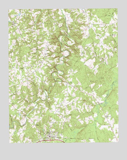
Polkton, NC USGS Topographic Map
Click on map above to begin viewing in our Map Viewer.

This topographic map contains these locations and features:
Feature Name Type Latitude Longitude GNIS ID View Map
Big BranchStreamN35.0379°W80.2198°981358View Map
Brown Creek ChurchChurchN35.0243°W80.1384°982012View Map
Brown Creek Church CemeteryCemeteryN35.0249°W80.1381°2778978View Map
BurnsvillePopulated PlaceN35.1124°W80.2445°982292View Map
Burnsville Fire and Rescue ServiceBuildingN35.1132°W80.2443°2638174View Map
Cabin BranchStreamN35.0535°W80.1331°982380View Map
Canebreak BranchStreamN35.0407°W80.2170°982603View Map
Cedar BranchStreamN35.0404°W80.2078°982793View Map
Cedar Grove ChurchChurchN35.0827°W80.2076°982837View Map
Cedar Grove Church CemeteryCemeteryN35.0829°W80.2085°2778983View Map
Cranes BranchStreamN35.0338°W80.1495°983718View Map
D and J Farms LakeReservoirN35.1202°W80.2370°998412View Map
D and J Farms Lake DamDamN35.1202°W80.2365°998411View Map
Deep Bottom BranchStreamN35.0996°W80.1823°984047View Map
Flag BranchStreamN35.0465°W80.2412°985142View Map
Griffins CrossroadsPopulated PlaceN35.0171°W80.2198°1006223View Map
Haileys BranchStreamN35.0104°W80.1706°986286View Map
Hopewell ChurchChurchN35.0699°W80.2331°987047View Map
Hopewell Church CemeteryCemeteryN35.0697°W80.2326°2778980View Map
Jacks BranchStreamN35.0568°W80.1287°987473View Map
KikersPopulated PlaceN35.0757°W80.2112°987950View Map
Lanesboro Fire DistrictBuildingN35.0061°W80.2040°2638391View Map
Little Brown CreekStreamN35.0018°W80.1845°988554View Map
Little Cribs CreekStreamN35.1135°W80.2198°988617View Map
Mount Vernon ChurchChurchN35.0574°W80.1567°990597View Map
Oak Dale ChurchChurchN35.0363°W80.2453°991346View Map
Pinch Gut CreekStreamN35.0160°W80.1509°992223View Map
Pleasant Hill ChurchChurchN35.1007°W80.1314°992519View Map
Pleasant Hill Church CemeteryCemeteryN35.1007°W80.1317°2778975View Map
PolktonPopulated PlaceN35.0077°W80.2009°992644View Map
Polkton Post OfficePost OfficeN35.0062°W80.2042°2773819View Map
Red Hill ChurchChurchN35.1082°W80.1578°993117View Map
Red Hill Church CemeteryCemeteryN35.1083°W80.1567°2778974View Map
Richmond - Sturdivant CemeteryCemeteryN35.0039°W80.1591°993326View Map
Rocky BranchStreamN35.0196°W80.2456°993568View Map
Saron ChurchChurchN35.0340°W80.1834°994351View Map
Saron Church CemeteryCemeteryN35.0338°W80.1830°2778979View Map
Sugar TownPopulated PlaceN35.0557°W80.1823°995652View Map
Town of PolktonCivilN35.0039°W80.1963°2407140View Map
Township of BurnsvilleCivilN35.1159°W80.2400°1026372View Map
Williams CemeteryCemeteryN35.0030°W80.2119°2778996View Map

Note: Coordinates in the location and feature list above are referenced to NAD83 datum.


Copyright (C) 2008-2025 Ryan Niemi / Sunset Dynamics ... All Rights Reserved