TopoQuest Logo
Do you find TopoQuest useful?
Help keep TopoQuest running and adding new maps/features by donating!
Bitcoin:  19c7KJd3qBynnjoSw5npx9KScwjBe4ifkT
Litecoin:  LXs6TkuXGGXo1vDsWCkWVdjQX94eUKd6ui
Home View Maps Find Maps Find Places Resources & Links


Dillsburg, Pennsylvania Topographic Map

USGS Map Title: Dillsburg, PA
USGS Map MRC: 40077A1
DRG (GeoTIFF) Download: o40077a1.tif


Neighboring USGS Topographic Map Quads:


  Carlisle, PA  
40077B2
 

  Mechanicsburg, PA  
40077B1
 

  Lemoyne, PA  
40076B8
 

  Mount Holly Springs, PA  
40077A2
 

  Dillsburg, PA  
40077A1
 

  Wellsville, PA  
40076A8
 

  Biglerville, PA  
39077H2
 

  Hampton, PA  
39077H1
 

  Abbottstown, PA  
39076H8


Map MRC Location:

N41°
W78°
N41°
W77°
H8 H7 H6 H5 H4 H3 H2 H1
G8 G7 G6 G5 G4 G3 G2 G1
F8 F7 F6 F5 F4 F3 F2 F1
E8 E7 E6 E5 E4 E3 E2 E1
D8 D7 D6 D5 D4 D3 D2 D1
C8 C7 C6 C5 C4 C3 C2 C1
B8 B7 B6 B5 B4 B3 B2 B1
A8 A7 A6 A5 A4 A3 A2 A1
N40°
W78°
N40°
W77°

Dillsburg, PA USGS 1:24K Topographic Map Preview:
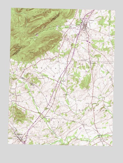
Dillsburg, PA USGS Topographic Map
Click on map above to begin viewing in our Map Viewer.

This topographic map contains these locations and features:
Feature Name Type Latitude Longitude GNIS ID View Map
Barrens SchoolSchoolN40.0618°W77.0025°1168762View Map
BeavertownPopulated PlaceN40.1079°W77.0528°1169069View Map
BermudianPopulated PlaceN40.0195°W77.0355°1169305View Map
Bermudian Valley AirparkAirportN40.0176°W77.0044°1193804View Map
Big DamLocaleN40.0351°W77.0228°1212378View Map
Big DamLocaleN40.0448°W77.0247°1169494View Map
Big Dam SchoolSchoolN40.0384°W77.0289°1169497View Map
Blackberry SchoolSchoolN40.0509°W77.1233°1169751View Map
Boners HillSummitN40.0276°W77.1147°1169975View Map
Borough of DillsburgCivilN40.1103°W77.0335°1215739View Map
Borough of FranklintownCivilN40.0760°W77.0295°1215744View Map
Borough of York SpringsCivilN40.0094°W77.1158°1214762View Map
Busheys SchoolSchoolN40.0440°W77.0953°1211136View Map
Camp TuckahoeLocaleN40.0981°W77.0961°1171109View Map
Center Point KnobSummitN40.1243°W77.1133°1171442View Map
Central SchoolSchoolN40.0765°W77.0655°1171494View Map
Chestnut Grove ChurchChurchN40.0445°W77.1172°1171712View Map
Chestnut Grove Lutheran Church CemeteryCemeteryN40.0443°W77.1176°2774874View Map
Chestnut HillPopulated PlaceN40.0637°W77.0855°1203268View Map
Chestnut Hill SchoolSchoolN40.0609°W77.0841°1171733View Map
Citizens Hose Company 1 Station 64BuildingN40.1093°W77.0347°2100020View Map
Clear SpringPopulated PlaceN40.0587°W77.0628°1171972View Map
Deardorffs MillPopulated PlaceN40.0254°W77.0808°1203394View Map
DillsburgPopulated PlaceN40.1109°W77.0350°1173273View Map
Dillsburg Area Public LibraryBuildingN40.1106°W77.0354°2100247View Map
Dillsburg CemeteryCemeteryN40.1090°W77.0419°1173274View Map
Dillsburg Post OfficePost OfficeN40.1120°W77.0356°2756671View Map
Franklin ChurchChurchN40.0656°W77.0553°1211273View Map
FranklintownPopulated PlaceN40.0768°W77.0283°1175179View Map
Franklintown Community Fire Company Station 65BuildingN40.0733°W77.0281°2652842View Map
Franklintown Post OfficePost OfficeN40.0764°W77.0284°2756640View Map
Gardners CemeteryCemeteryN40.0388°W77.1161°2774880View Map
Gardners ChurchChurchN40.0390°W77.1161°1175445View Map
Glenwood SchoolSchoolN40.0784°W77.0341°1175749View Map
Gochenours SchoolSchoolN40.0162°W77.0194°1175769View Map
Harbolds SchoolSchoolN40.0393°W77.1219°1176495View Map
Harmony ChurchChurchN40.0651°W77.1036°1176548View Map
Holy Trinity Church CemeteryCemeteryN40.0067°W77.1121°2774891View Map
HomewoodPopulated PlaceN40.1098°W77.0441°1177331View Map
Kimmels SchoolSchoolN40.0365°W77.0064°1178469View Map
LatimorePopulated PlaceN40.0456°W77.1211°1178905View Map
Latimore ChurchChurchN40.0326°W77.0755°1178906View Map
Latimore CreekStreamN40.0040°W77.0614°1178907View Map
Latimore Mennonite Meetinghouse CemeteryCemeteryN40.0326°W77.0760°2774897View Map
Lobach - Bushey CemeteryCemeteryN40.0434°W77.0930°2774899View Map
Locust Grove SchoolSchoolN40.0468°W77.0539°1179781View Map
Long MountainSummitN40.0887°W77.1178°1179867View Map
Mathna AirportAirportN40.0162°W77.0414°2442815View Map
Mechanicsville SchoolSchoolN40.0143°W77.0316°1180851View Map
Northern Joint High SchoolSchoolN40.0962°W77.0322°1182670View Map
Northern SchoolSchoolN40.0970°W77.0603°1211150View Map
Plainfield SchoolSchoolN40.0159°W77.0725°1183989View Map
Pond Mill BridgeBridgeN40.0014°W77.0586°2723090View Map
Pondtown Mill (historical)LocaleN40.0043°W77.0558°1211134View Map
Presbyterian CemeteryCemeteryN40.0022°W77.1111°2774926View Map
Red Mount ChurchChurchN40.0051°W77.0100°1184770View Map
Salem ChurchChurchN40.0626°W77.0019°1186818View Map
State Game Lands Number 243ParkN40.0668°W77.0414°1208345View Map
State Game Lands Number 305ParkN40.1168°W77.1164°1208064View Map
State Road SchoolSchoolN40.0170°W77.0941°1188561View Map
State Road SchoolSchoolN40.0906°W77.0255°1211137View Map
Stone HeadSummitN40.0851°W77.0936°1188721View Map
Stony Brook SchoolSchoolN40.1020°W77.0066°1188758View Map
Sunny Side CemeteryCemeteryN40.0225°W77.1154°1189072View Map
Swamp SchoolSchoolN40.0140°W77.0705°1211135View Map
Township of CarrollCivilN40.1142°W77.0191°1217280View Map
Township of FranklinCivilN40.0706°W77.0704°1217289View Map
Township of LatimoreCivilN40.0216°W77.0873°1215787View Map
Union ChurchChurchN40.0790°W77.0753°1190133View Map
UniontownPopulated PlaceN40.0654°W77.0555°1211009View Map
United ChurchChurchN40.1084°W77.0519°1190197View Map
Western SchoolSchoolN40.0684°W77.1069°1191149View Map
White RocksSummitN40.1234°W77.1047°1191314View Map
WKCD-FM (Mechanicsburg)TowerN40.1223°W77.0691°1214708View Map
Wolf RunStreamN40.0307°W77.0028°1191680View Map
York SpringsPopulated PlaceN40.0090°W77.1155°1191906View Map
York Springs Fire Company 1 Station 9BuildingN40.0103°W77.1149°2652608View Map
York Springs Police DepartmentBuildingN40.0146°W77.0973°2754569View Map
York Springs Post OfficePost OfficeN40.0054°W77.1119°2756698View Map

Note: Coordinates in the location and feature list above are referenced to NAD83 datum.


Copyright (C) 2008-2025 Ryan Niemi / Sunset Dynamics ... All Rights Reserved