TopoQuest Logo
Do you find TopoQuest useful?
Help keep TopoQuest running and adding new maps/features by donating!
Bitcoin:  19c7KJd3qBynnjoSw5npx9KScwjBe4ifkT
Litecoin:  LXs6TkuXGGXo1vDsWCkWVdjQX94eUKd6ui
Home View Maps Find Maps Find Places Resources & Links


Mechanicsburg, Pennsylvania Topographic Map

USGS Map Title: Mechanicsburg, PA
USGS Map MRC: 40077B1
DRG (GeoTIFF) Download: o40077b1.tif


Neighboring USGS Topographic Map Quads:


  Shermans Dale, PA  
40077C2
 

  Wertzville, PA  
40077C1
 

  Harrisburg West, PA  
40076C8
 

  Carlisle, PA  
40077B2
 

  Mechanicsburg, PA  
40077B1
 

  Lemoyne, PA  
40076B8
 

  Mount Holly Springs, PA  
40077A2
 

  Dillsburg, PA  
40077A1
 

  Wellsville, PA  
40076A8


Map MRC Location:

N41°
W78°
N41°
W77°
H8 H7 H6 H5 H4 H3 H2 H1
G8 G7 G6 G5 G4 G3 G2 G1
F8 F7 F6 F5 F4 F3 F2 F1
E8 E7 E6 E5 E4 E3 E2 E1
D8 D7 D6 D5 D4 D3 D2 D1
C8 C7 C6 C5 C4 C3 C2 C1
B8 B7 B6 B5 B4 B3 B2 B1
A8 A7 A6 A5 A4 A3 A2 A1
N40°
W78°
N40°
W77°

Mechanicsburg, PA USGS 1:24K Topographic Map Preview:
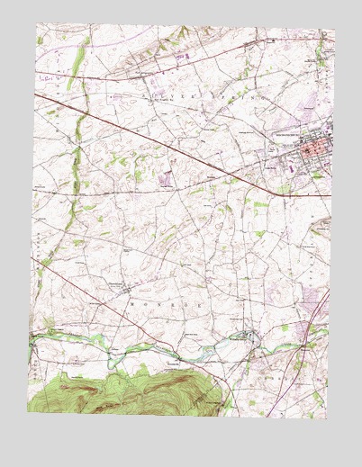
Mechanicsburg, PA USGS Topographic Map
Click on map above to begin viewing in our Map Viewer.

This topographic map contains these locations and features:
Feature Name Type Latitude Longitude GNIS ID View Map
AllenPopulated PlaceN40.1654°W77.0844°1211166View Map
Allenberry PlayhouseBuildingN40.1509°W77.1150°1168190View Map
Anderson SchoolSchoolN40.2173°W77.0544°1168289View Map
Bailey SchoolSchoolN40.1365°W77.0153°1211203View Map
Bakers Church CemeteryCemeteryN40.1783°W77.0842°1168612View Map
Bell SchoolSchoolN40.1531°W77.0839°1211204View Map
Berkshire HillsPopulated PlaceN40.1398°W77.0297°1201739View Map
Bethel Church (historical)ChurchN40.1662°W77.0836°1211199View Map
Borough of MechanicsburgCivilN40.2115°W77.0060°1215149View Map
BrandtsvillePopulated PlaceN40.1431°W77.0619°1170160View Map
Brindle SchoolSchoolN40.1726°W77.1016°1170259View Map
Brindles SchoolSchoolN40.1406°W77.1055°1170260View Map
Broad Street Elementary SchoolSchoolN40.2075°W77.0169°1211559View Map
Carroll ManorPopulated PlaceN40.1343°W77.0122°1201738View Map
Center Square ParkParkN40.1615°W77.0119°1206887View Map
Chestnut HillSummitN40.1854°W77.0011°1192255View Map
Chestnut Hill CemeteryCemeteryN40.1879°W77.0013°1171729View Map
ChurchtownPopulated PlaceN40.1651°W77.0841°1171874View Map
Citizens Fire and Rescue Company Station 27BuildingN40.2100°W77.0134°2652626View Map
Country EstatesPopulated PlaceN40.1843°W77.0180°1201736View Map
Cumberland Valley High SchoolSchoolN40.2401°W77.0547°1211476View Map
D and M JunctionLocaleN40.1434°W77.0330°1211168View Map
Dillsburg JunctionPopulated PlaceN40.2162°W77.0322°1203421View Map
Dogwood RunStreamN40.1473°W77.0291°1173351View Map
Fishers RunStreamN40.1265°W77.0069°1174830View Map
Garrett Grove SchoolSchoolN40.1801°W77.0125°1175465View Map
Givler SchoolSchoolN40.1731°W77.0614°1175648View Map
Heberling SchoolSchoolN40.2448°W77.1216°1176736View Map
Heberling School (historical)SchoolN40.2448°W77.1211°1211201View Map
Hidden SpringSpringN40.2134°W77.1103°1202296View Map
HogestownPopulated PlaceN40.2459°W77.0328°1177180View Map
Independent SchoolSchoolN40.1951°W77.1055°1211196View Map
KingtownPopulated PlaceN40.2404°W77.0753°1211198View Map
Kohlertown SchoolSchoolN40.2020°W77.0075°1994126View Map
Le High ParkPopulated PlaceN40.1781°W77.0464°1201735View Map
LeidighsPopulated PlaceN40.1445°W77.0911°1204004View Map
Liebys Trailer ParkPopulated PlaceN40.2290°W77.1030°1214224View Map
Lines SchoolSchoolN40.1918°W77.0497°1179421View Map
Locust PointPopulated PlaceN40.1973°W77.0639°1179788View Map
Maple Grove SchoolSchoolN40.1506°W77.0597°1180340View Map
MechanicsburgPopulated PlaceN40.2143°W77.0086°1180844View Map
Mechanicsburg Area Intermediate SchoolSchoolN40.2068°W77.0022°1211555View Map
Mechanicsburg Area Senior High SchoolSchoolN40.2046°W77.0167°1211556View Map
Mechanicsburg Borough Police DepartmentBuildingN40.2142°W77.0103°2754577View Map
Mennonite Church (historical)ChurchN40.1615°W77.0908°1211197View Map
Middle School WestSchoolN40.2401°W77.0547°1211477View Map
Monroe Elementary SchoolSchoolN40.1668°W77.0803°1211731View Map
Monroe Fire Company Station 25BuildingN40.1676°W77.0731°2653139View Map
Mount Oliver CampgroundsLocaleN40.1293°W77.0433°1181771View Map
Mount Zion CemeteryCemeteryN40.1587°W77.0950°1181900View Map
Mummas SchoolSchoolN40.2270°W77.0266°1211200View Map
Neiderer AirportAirportN40.2209°W77.1135°1193876View Map
New Kingston StationLocaleN40.2256°W77.0758°1182340View Map
New KingstownPopulated PlaceN40.2331°W77.0797°1182341View Map
New Kingstown Census Designated PlaceCensusN40.2311°W77.0727°2389542View Map
New Kingstown Fire Company Station 33BuildingN40.2309°W77.0790°2652634View Map
New Kingstown Post OfficePost OfficeN40.2343°W77.0774°2779920View Map
Northside Elementary SchoolSchoolN40.2201°W77.0066°1211558View Map
Oak Grove SchoolSchoolN40.1829°W77.0294°1182755View Map
Oak Grove School (historical)SchoolN40.1829°W77.0289°1211202View Map
Reading BanksSlopeN40.1354°W77.1047°1184734View Map
Rifes SchoolSchoolN40.1629°W77.0350°1185060View Map
Rose GardenPopulated PlaceN40.1534°W77.0114°1201737View Map
Rose Garden ParkParkN40.1501°W77.0125°1206886View Map
RosegardenPopulated PlaceN40.1479°W77.0111°1204545View Map
RoxburyPopulated PlaceN40.2006°W77.0503°1185585View Map
Salem Church (historical)ChurchN40.1831°W77.1100°1211195View Map
Silver SpringSpringN40.2412°W77.0066°1202290View Map
Silver Spring Ambulance and Rescue Station 72BuildingN40.2332°W77.0720°2719467View Map
Silver Spring Community Fire Company Station 31BuildingN40.2455°W77.0173°2653059View Map
Silver Spring Elementary SchoolSchoolN40.2418°W77.0647°1211475View Map
Silver Spring Meeting HouseBuildingN40.2412°W77.0053°1187693View Map
Silver Spring Presbyterian Church CemeteryCemeteryN40.2394°W77.0070°1190583View Map
Soldier and Sailor Memorial ParkParkN40.2131°W77.0183°1187979View Map
Stony RidgeRidgeN40.2020°W77.1066°1193480View Map
SunnylandPopulated PlaceN40.2029°W77.0114°1202027View Map
Taylor Aviation Air Field (historical)AirportN40.2343°W77.0697°1206888View Map
Township of MonroeCivilN40.1612°W77.0701°1216340View Map
Trindle SpringSpringN40.2065°W77.0233°1202464View Map
Trindle SpringsPopulated PlaceN40.2065°W77.0233°1189767View Map
Valley Stream EstatesPopulated PlaceN40.2101°W77.0297°1201734View Map
Washington Fire Company Station 28BuildingN40.2139°W77.0068°2653109View Map
WebercroftPopulated PlaceN40.2018°W77.0014°1201733View Map
White Rock AcresPopulated PlaceN40.1290°W77.0822°1201740View Map
Williams GrovePopulated PlaceN40.1518°W77.0347°1191460View Map
Williams Grove HeliportAirportN40.1501°W77.0330°1213745View Map
Williams Grove ParkParkN40.1556°W77.0336°1191461View Map
Williams Mill (historical)LocaleN40.1526°W77.0305°1211167View Map

Note: Coordinates in the location and feature list above are referenced to NAD83 datum.


Copyright (C) 2008-2025 Ryan Niemi / Sunset Dynamics ... All Rights Reserved