TopoQuest Logo
Do you find TopoQuest useful?
Help keep TopoQuest running and adding new maps/features by donating!
Bitcoin:  19c7KJd3qBynnjoSw5npx9KScwjBe4ifkT
Litecoin:  LXs6TkuXGGXo1vDsWCkWVdjQX94eUKd6ui
Home View Maps Find Maps Find Places Resources & Links


Fishhook, Illinois Topographic Map

USGS Map Title: Fishhook, IL
USGS Map MRC: 39090G8
DRG (GeoTIFF) Download: o39090g8.tif


Neighboring USGS Topographic Map Quads:


  Liberty, IL  
39091H1
 

  Kellerville, IL  
39090H8
 

  Mount Sterling, IL  
39090H7
 

  Richfield, IL  
39091G1
 

  Fishhook, IL  
39090G8
 

  Perry West, IL  
39090G7
 

  Barry, IL  
39091F1
 

  Baylis, IL  
39090F8
 

  New Salem, IL  
39090F7


Map MRC Location:

N40°
W91°
N40°
W90°
H8 H7 H6 H5 H4 H3 H2 H1
G8 G7 G6 G5 G4 G3 G2 G1
F8 F7 F6 F5 F4 F3 F2 F1
E8 E7 E6 E5 E4 E3 E2 E1
D8 D7 D6 D5 D4 D3 D2 D1
C8 C7 C6 C5 C4 C3 C2 C1
B8 B7 B6 B5 B4 B3 B2 B1
A8 A7 A6 A5 A4 A3 A2 A1
N39°
W91°
N39°
W90°

Fishhook, IL USGS 1:24K Topographic Map Preview:
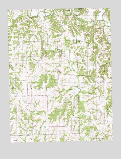
Fishhook, IL USGS Topographic Map
Click on map above to begin viewing in our Map Viewer.

This topographic map contains these locations and features:
Feature Name Type Latitude Longitude GNIS ID View Map
BeverlyPopulated PlaceN39.7934°W90.9910°404356View Map
Beverly Old CemeteryCemeteryN39.7962°W90.9912°1984913View Map
Bowman CemeteryCemeteryN39.8587°W90.9148°1720760View Map
ChestlinePopulated PlaceN39.8448°W90.9599°422546View Map
Crabapple CreekStreamN39.8742°W90.9324°406709View Map
East School (historical)SchoolN39.8198°W90.9471°407694View Map
Fairmount School (historical)SchoolN39.8303°W90.9037°408184View Map
Fairview CemeteryCemeteryN39.8589°W90.9360°1720520View Map
Ferguson FordCrossingN39.8612°W90.9035°422696View Map
FishhookPopulated PlaceN39.8056°W90.8854°408403View Map
Fishhook CreekStreamN39.8684°W90.9529°408404View Map
Greenwood School (historical)SchoolN39.8556°W90.9365°409471View Map
Highland School (historical)SchoolN39.8667°W90.9735°410228View Map
Kurfman CemeteryCemeteryN39.8225°W90.9043°1747248View Map
Lanes BranchStreamN39.8598°W90.9579°411804View Map
Little Missouri CreekStreamN39.8737°W90.8837°412374View Map
Long RidgeRidgeN39.7712°W90.9282°412603View Map
Mayfield Family CemeteryCemeteryN39.8014°W90.9968°1720546View Map
Mixer Family CemeteryCemeteryN39.8328°W90.9354°1720551View Map
Mound Prairie CemeteryCemeteryN39.7931°W90.9785°1984973View Map
Mound Prairie ChurchChurchN39.7925°W90.9799°414150View Map
Mound School (historical)SchoolN39.7864°W90.9496°413919View Map
Oak Grove School (historical)SchoolN39.8270°W90.9912°414804View Map
Perrigo CemeteryCemeteryN39.8606°W90.9604°1984983View Map
Pierce CemeteryCemeteryN39.7520°W90.9960°1747255View Map
Pleasant Hill School (historical)SchoolN39.7570°W90.9674°415847View Map
Reddick School (historical)SchoolN39.8514°W90.9035°416473View Map
Rubart CemeteryCemeteryN39.7987°W90.9271°1720566View Map
Seybold CemeteryCemeteryN39.7945°W90.9043°1747260View Map
The MoundSummitN39.7903°W90.9543°419634View Map
Township of BeverlyCivilN39.8010°W90.9732°428668View Map
Whiaker CemeteryCemeteryN39.8567°W90.9501°1984990View Map
Winner CemeteryCemeteryN39.7564°W90.9885°1747277View Map
Woodland CemeteryCemeteryN39.7739°W90.8848°1852505View Map
Woodland ChurchChurchN39.7739°W90.8849°1747278View Map
Woodland School (historical)SchoolN39.7745°W90.8843°421442View Map

Note: Coordinates in the location and feature list above are referenced to NAD83 datum.


Copyright (C) 2008-2024 Ryan Niemi / Sunset Dynamics ... All Rights Reserved