TopoQuest Logo
Do you find TopoQuest useful?
Help keep TopoQuest running and adding new maps/features by donating!
Bitcoin:  19c7KJd3qBynnjoSw5npx9KScwjBe4ifkT
Litecoin:  LXs6TkuXGGXo1vDsWCkWVdjQX94eUKd6ui
Home View Maps Find Maps Find Places Resources & Links


Wildie, Kentucky Topographic Map

USGS Map Title: Wildie, KY
USGS Map MRC: 37084D3
DRG (GeoTIFF) Download: o37084d3.tif


Neighboring USGS Topographic Map Quads:


  Paint Lick, KY  
37084E4
 

  Berea, KY  
37084E3
 

  Bighill, KY  
37084E2
 

  Brodhead, KY  
37084D4
 

  Wildie, KY  
37084D3
 

  Johnetta, KY  
37084D2
 

  Maretburg, KY  
37084C4
 

  Mount Vernon, KY  
37084C3
 

  Livingston, KY  
37084C2


Map MRC Location:

N38°
W85°
N38°
W84°
H8 H7 H6 H5 H4 H3 H2 H1
G8 G7 G6 G5 G4 G3 G2 G1
F8 F7 F6 F5 F4 F3 F2 F1
E8 E7 E6 E5 E4 E3 E2 E1
D8 D7 D6 D5 D4 D3 D2 D1
C8 C7 C6 C5 C4 C3 C2 C1
B8 B7 B6 B5 B4 B3 B2 B1
A8 A7 A6 A5 A4 A3 A2 A1
N37°
W85°
N37°
W84°

Wildie, KY USGS 1:24K Topographic Map Preview:
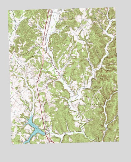
Wildie, KY USGS Topographic Map
Click on map above to begin viewing in our Map Viewer.

This topographic map contains these locations and features:
Feature Name Type Latitude Longitude GNIS ID View Map
Big Hurricane BranchStreamN37.4632°W84.3287°510665View Map
Brindle RidgeRidgeN37.4429°W84.3560°510926View Map
Brindle Ridge Baptist ChurchChurchN37.4340°W84.3413°510927View Map
Brindle Ridge Fire DepartmentBuildingN37.4690°W84.3330°2636369View Map
Brush CreekStreamN37.3751°W84.2685°510966View Map
Buckeye ChurchChurchN37.3831°W84.3119°511020View Map
Clay Lick BranchStreamN37.4724°W84.3305°511387View Map
Clear CreekStreamN37.4137°W84.3060°511394View Map
Clear Creek ChurchChurchN37.4904°W84.2555°511396View Map
ConwayPopulated PlaceN37.4779°W84.3344°511504View Map
Conway DivisionCivilN37.4656°W84.2924°1936945View Map
Conway Railroad Station (historical)LocaleN37.4737°W84.3320°2726008View Map
Cove SchoolSchoolN37.4043°W84.2519°511583View Map
Crane BranchStreamN37.4898°W84.3660°511619View Map
Crawford AirportAirportN37.4204°W84.3691°517342View Map
Davis BranchStreamN37.4870°W84.2552°511737View Map
DisputantaPopulated PlaceN37.4884°W84.2574°511822View Map
Fairview ChurchChurchN37.4986°W84.3158°512111View Map
HummelPopulated PlaceN37.3965°W84.2855°512847View Map
Johnetta SchoolSchoolN37.4218°W84.2502°516573View Map
Kentucky Music Hall of Fame and MuseumBuildingN37.3881°W84.3302°1989326View Map
Lake LinvilleReservoirN37.3849°W84.3490°513442View Map
Langford Railroad Station (historical)LocaleN37.3890°W84.2924°2726027View Map
Lear KnobSummitN37.4273°W84.3644°513279View Map
Linville KnobSummitN37.4720°W84.3072°513441View Map
Little Clear CreekStreamN37.4915°W84.3183°513466View Map
Little Hurricane BranchStreamN37.4650°W84.3376°513490View Map
Little Renfro CreekStreamN37.3906°W84.3460°513515View Map
Loman BranchStreamN37.4706°W84.2530°513577View Map
May Apple ChurchChurchN37.4918°W84.3135°513834View Map
Merritt CemeteryCemeteryN37.4040°W84.3016°513908View Map
Mount Zion ChurchChurchN37.4134°W84.3560°514120View Map
New Testament ChurchChurchN37.4501°W84.3259°514250View Map
North Fork Copper CreekStreamN37.4749°W84.3733°510192View Map
Owens KnobSummitN37.4920°W84.2966°514395View Map
Renfro CreekStreamN37.3831°W84.2916°514888View Map
Renfro ValleyPopulated PlaceN37.3879°W84.3316°514889View Map
Renfro Valley Barn Dance and Pioneer MuseumBuildingN37.3873°W84.3302°2726034View Map
Riddle CemeteryCemeteryN37.4429°W84.3513°514918View Map
Rimmel CemeteryCemeteryN37.4381°W84.3353°512712View Map
Rose Hill ChurchChurchN37.3787°W84.3574°515108View Map
RoundstonePopulated PlaceN37.4384°W84.3147°515135View Map
Roundstone Railroad Station (historical)LocaleN37.4391°W84.3164°2726036View Map
Salt Spring HollowValleyN37.4926°W84.2599°515197View Map
Saylor CemeteryCemeteryN37.4587°W84.3633°515271View Map
Scaffold Cane BranchStreamN37.4434°W84.2780°515274View Map
Scaffold Cane ChurchChurchN37.4829°W84.2899°515275View Map
Sigmon CemeteryCemeteryN37.4306°W84.3313°515405View Map
Snider Switch StationLocaleN37.4958°W84.3243°2726039View Map
Todd BranchStreamN37.4776°W84.2599°515961View Map
Town BranchStreamN37.3795°W84.3174°515983View Map
Travis Todds Tannery (historical)LocaleN37.4771°W84.2608°2726065View Map
Turkey Pen HollowValleyN37.4522°W84.2680°516057View Map
Union ChapelChurchN37.4556°W84.3733°516098View Map
Valley Spring BranchStreamN37.4776°W84.3258°516173View Map
Wards Railroad Station (historical)LocaleN37.4023°W84.2949°2726070View Map
WildiePopulated PlaceN37.4234°W84.3022°516373View Map
Wolf CreekStreamN37.3895°W84.2644°516438View Map
WRVK-AM (Mount Vernon)TowerN37.3847°W84.3293°517869View Map

Note: Coordinates in the location and feature list above are referenced to NAD83 datum.


Copyright (C) 2008-2025 Ryan Niemi / Sunset Dynamics ... All Rights Reserved