TopoQuest Logo
Do you find TopoQuest useful?
Help keep TopoQuest running and adding new maps/features by donating!
Bitcoin:  19c7KJd3qBynnjoSw5npx9KScwjBe4ifkT
Litecoin:  LXs6TkuXGGXo1vDsWCkWVdjQX94eUKd6ui
Home View Maps Find Maps Find Places Resources & Links


Mount Vision, New York Topographic Map

USGS Map Title: Mount Vision, NY
USGS Map MRC: 42075E1
DRG (GeoTIFF) Download: o42075e1.tif


Neighboring USGS Topographic Map Quads:


  Edmeston, NY  
42075F2
 

  Hartwick, NY  
42075F1
 

  Cooperstown, NY  
42074F8
 

  Morris, NY  
42075E2
 

  Mount Vision, NY  
42075E1
 

  Milford, NY  
42074E8
 

  Otego, NY  
42075D2
 

  Oneonta, NY  
42075D1
 

  West Davenport, NY  
42074D8


Map MRC Location:

N43°
W76°
N43°
W75°
H8 H7 H6 H5 H4 H3 H2 H1
G8 G7 G6 G5 G4 G3 G2 G1
F8 F7 F6 F5 F4 F3 F2 F1
E8 E7 E6 E5 E4 E3 E2 E1
D8 D7 D6 D5 D4 D3 D2 D1
C8 C7 C6 C5 C4 C3 C2 C1
B8 B7 B6 B5 B4 B3 B2 B1
A8 A7 A6 A5 A4 A3 A2 A1
N42°
W76°
N42°
W75°

Mount Vision, NY USGS 1:24K Topographic Map Preview:
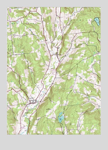
Mount Vision, NY USGS Topographic Map
Click on map above to begin viewing in our Map Viewer.

This topographic map contains these locations and features:
Feature Name Type Latitude Longitude GNIS ID View Map
Arnold LakeLakeN42.6114°W75.0044°942579View Map
Babcock CemeteryCemeteryN42.5185°W75.0744°942748View Map
Bowe HillSummitN42.6035°W75.0200°2790680View Map
Bunn HillSummitN42.6140°W75.0432°945187View Map
East HillSummitN42.5240°W75.0702°949111View Map
Elm Row CemeteryCemeteryN42.5275°W75.0989°2358514View Map
Fall BridgePopulated PlaceN42.5922°W75.0733°2365188View Map
Gifford HillSummitN42.5224°W75.0345°951078View Map
Gifford HillSummitN42.5192°W75.0391°951079View Map
Keyes BrookStreamN42.5706°W75.0607°954578View Map
Lake BrookStreamN42.5320°W75.0841°954899View Map
Lane HillSummitN42.5787°W75.0240°955026View Map
LaurensPopulated PlaceN42.5306°W75.0896°955097View Map
Laurens Central SchoolSchoolN42.5316°W75.0885°2597214View Map
Laurens Post OfficePost OfficeN42.5338°W75.0876°2598928View Map
Laurens Presbyterian ChurchChurchN42.5308°W75.0938°2597899View Map
Laurens Village CemeteryCemeteryN42.5319°W75.0950°2558757View Map
Laurens Volunteer Fire DepartmentBuildingN42.5305°W75.0909°2735151View Map
LenaPopulated PlaceN42.6242°W75.0841°972718View Map
Lena CemeteryCemeteryN42.6137°W75.0790°955193View Map
Maple Grove CemeteryCemeteryN42.5273°W75.0991°956409View Map
Meadow Vale CampsitesLocaleN42.6062°W75.1248°2598951View Map
Mount VisionPopulated PlaceN42.5784°W75.0579°957927View Map
Mount Vision CemeteryCemeteryN42.5783°W75.0650°2558758View Map
Mount Vision Post OfficePost OfficeN42.5786°W75.0582°2598931View Map
Mount Vision Volunteer Fire DepartmentBuildingN42.5787°W75.0600°2735153View Map
Old Mount Vision CemeteryCemeteryN42.5765°W75.0575°2558759View Map
Oneonta Municipal AirportAirportN42.5217°W75.0667°978204View Map
Pleasant ValleyValleyN42.6009°W75.0507°960728View Map
Pool BrookStreamN42.5395°W75.0802°960913View Map
Saint Matthew Lutheran ChurchChurchN42.5332°W75.0868°2597912View Map
School Number 10 (historical)SchoolN42.5976°W75.1152°974938View Map
School Number 11 (historical)SchoolN42.6154°W75.0996°974979View Map
School Number 13 (historical)SchoolN42.5054°W75.0304°975052View Map
School Number 14 (historical)SchoolN42.6201°W75.0343°975083View Map
School Number 3 (historical)SchoolN42.5742°W75.0566°975249View Map
School Number 5 (historical)SchoolN42.5912°W75.0732°975403View Map
School Number 9 (historical)SchoolN42.5759°W75.0146°975630View Map
South HartwickPopulated PlaceN42.6167°W75.0582°965766View Map
Tiffany CemeteryCemeteryN42.5809°W75.1171°967515View Map
Town of LaurensCivilN42.5380°W75.1162°979133View Map
Village of LaurensCivilN42.5313°W75.0887°2390935View Map
West Branch Otego CreekStreamN42.5892°W75.0577°969130View Map
Wharton CreekStreamN42.5062°W75.0968°970978View Map
Wilber LakeLakeN42.5170°W75.0528°971232View Map

Note: Coordinates in the location and feature list above are referenced to NAD83 datum.


Copyright (C) 2008-2025 Ryan Niemi / Sunset Dynamics ... All Rights Reserved