TopoQuest Logo
Do you find TopoQuest useful?
Help keep TopoQuest running and adding new maps/features by donating!
Bitcoin:  19c7KJd3qBynnjoSw5npx9KScwjBe4ifkT
Litecoin:  LXs6TkuXGGXo1vDsWCkWVdjQX94eUKd6ui
Home View Maps Find Maps Find Places Resources & Links


Bingham, Illinois Topographic Map

USGS Map Title: Bingham, IL
USGS Map MRC: 39089A2
DRG (GeoTIFF) Download: o39089a2.tif


Neighboring USGS Topographic Map Quads:


  Bald Knob, IL  
39089B3
 

  Ramsey Lake, IL  
39089B2
 

  Ramsey, IL  
39089B1
 

  Fillmore, IL  
39089A3
 

  Bingham, IL  
39089A2
 

  Vera, IL  
39089A1
 

  Mulberry Grove, IL  
38089H3
 

  Hagarstown, IL  
38089H2
 

  Vandalia, IL  
38089H1


Map MRC Location:

N40°
W90°
N40°
W89°
H8 H7 H6 H5 H4 H3 H2 H1
G8 G7 G6 G5 G4 G3 G2 G1
F8 F7 F6 F5 F4 F3 F2 F1
E8 E7 E6 E5 E4 E3 E2 E1
D8 D7 D6 D5 D4 D3 D2 D1
C8 C7 C6 C5 C4 C3 C2 C1
B8 B7 B6 B5 B4 B3 B2 B1
A8 A7 A6 A5 A4 A3 A2 A1
N39°
W90°
N39°
W89°

Bingham, IL USGS 1:24K Topographic Map Preview:
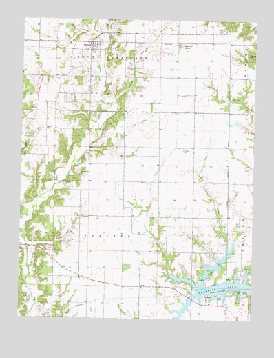
Bingham, IL USGS Topographic Map
Click on map above to begin viewing in our Map Viewer.

This topographic map contains these locations and features:
Feature Name Type Latitude Longitude GNIS ID View Map
Bayle CityPopulated PlaceN39.1139°W89.1662°403986View Map
Bear Creek School (historical)SchoolN39.0431°W89.1570°1736918View Map
Bethel ChurchChurchN39.0175°W89.2173°404301View Map
BinghamPopulated PlaceN39.1142°W89.2134°404451View Map
Brackenbush CemeteryCemeteryN39.0825°W89.2448°1802259View Map
Browning CemeteryCemeteryN39.0320°W89.2256°404971View Map
Browning School (historical)SchoolN39.0170°W89.2226°1736929View Map
Brush College School (historical)SchoolN39.0428°W89.2317°1736930View Map
Burnett School (historical)SchoolN39.0059°W89.1428°1736932View Map
Canaan ChurchChurchN39.0792°W89.2365°405541View Map
Cloverleaf School (historical)SchoolN39.1084°W89.2420°1736935View Map
Cook CemeteryCemeteryN39.0611°W89.2145°406498View Map
Crisson School (historical)SchoolN39.0684°W89.1931°1736938View Map
Dry ForkStreamN39.0364°W89.2487°407423View Map
Hoffman CemeteryCemeteryN39.0706°W89.1637°410339View Map
Holy Cross Lutheran CemeteryCemeteryN39.0578°W89.1495°1802265View Map
Isbell CemeteryCemeteryN39.0875°W89.2459°410947View Map
Lawler CemeteryCemeteryN39.0192°W89.1481°411856View Map
Liberty CreekStreamN39.1139°W89.2051°412005View Map
Monclovia CemeteryCemeteryN39.1098°W89.1281°413718View Map
Panther CreekStreamN39.0892°W89.2015°415351View Map
Peak School (historical)SchoolN39.0139°W89.1809°1736976View Map
Pope CemeteryCemeteryN39.1045°W89.1901°416019View Map
Rush CemeteryCemeteryN39.0567°W89.2270°417051View Map
Rush School (historical)SchoolN39.0431°W89.1945°1736988View Map
ShafterPopulated PlaceN39.0137°W89.1851°423179View Map
Spunk School (historical)SchoolN39.0753°W89.2367°1737000View Map
Township of ShafterCivilN39.0428°W89.1945°429735View Map
Township of South HurricaneCivilN39.1193°W89.1949°429769View Map
Vandalia LakeReservoirN39.0044°W89.1616°403314View Map
Vandalia Municipal ReservoirReservoirN39.0098°W89.1564°1691745View Map
Village of BinghamCivilN39.1122°W89.2137°2398122View Map
Washington School (historical)SchoolN39.0723°W89.1576°1737011View Map

Note: Coordinates in the location and feature list above are referenced to NAD83 datum.


Copyright (C) 2008-2025 Ryan Niemi / Sunset Dynamics ... All Rights Reserved