TopoQuest Logo
Do you find TopoQuest useful?
Help keep TopoQuest running and adding new maps/features by donating!
Bitcoin:  19c7KJd3qBynnjoSw5npx9KScwjBe4ifkT
Litecoin:  LXs6TkuXGGXo1vDsWCkWVdjQX94eUKd6ui
Home View Maps Find Maps Find Places Resources & Links


Murfreesboro, Arkansas Topographic Map

USGS Map Title: Murfreesboro, AR
USGS Map MRC: 34093A6
DRG (GeoTIFF) Download: o34093a6.tif


Neighboring USGS Topographic Map Quads:


  Center Point NE, AR  
34093B7
 

  Narrows Dam, AR  
34093B6
 

  Murfreesboro NE, AR  
34093B5
 

  Nathan, AR  
34093A7
 

  Murfreesboro, AR  
34093A6
 

  Delight, AR  
34093A5
 

  Nashville, AR  
33093H7
 

  McCaskill, AR  
33093H6
 

  Pisgah, AR  
33093H5


Map MRC Location:

N35°
W94°
N35°
W93°
H8 H7 H6 H5 H4 H3 H2 H1
G8 G7 G6 G5 G4 G3 G2 G1
F8 F7 F6 F5 F4 F3 F2 F1
E8 E7 E6 E5 E4 E3 E2 E1
D8 D7 D6 D5 D4 D3 D2 D1
C8 C7 C6 C5 C4 C3 C2 C1
B8 B7 B6 B5 B4 B3 B2 B1
A8 A7 A6 A5 A4 A3 A2 A1
N34°
W94°
N34°
W93°

Murfreesboro, AR USGS 1:24K Topographic Map Preview:
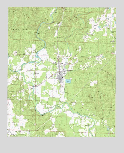
Murfreesboro, AR USGS Topographic Map
Click on map above to begin viewing in our Map Viewer.

This topographic map contains these locations and features:
Feature Name Type Latitude Longitude GNIS ID View Map
Alford LakeLakeN34.0285°W93.6979°75625View Map
American MineMineN34.0546°W93.6346°81581View Map
Arkansas MineMineN34.0318°W93.6735°81582View Map
Arp (historical)Populated PlaceN34.1062°W93.6319°64596View Map
Ball (historical)Populated PlaceN34.0071°W93.7085°64599View Map
Blocker CreekStreamN34.0126°W93.6488°46722View Map
Caney CreekStreamN34.0612°W93.6807°47406View Map
City of MurfreesboroCivilN34.0651°W93.6903°2404341View Map
College Hill CemeteryCemeteryN34.0787°W93.7355°47926View Map
Crater of DiamondsMineN34.0318°W93.6732°48147View Map
Crater of Diamonds State ParkParkN34.0334°W93.6724°64608View Map
East HillSummitN34.0346°W93.6735°81583View Map
Emergency Medical TransportBuildingN34.0704°W93.6846°2119057View Map
Hickory Grove ChurchChurchN34.0179°W93.6405°50063View Map
Japany ChurchChurchN34.0212°W93.6557°50592View Map
Johnson BranchStreamN34.1037°W93.6688°50675View Map
KimberleyPopulated PlaceN34.0437°W93.6891°58019View Map
Kimberlite MineMineN34.0548°W93.6399°81584View Map
KMTB-FM (Murfreesboro)TowerN34.0957°W93.6921°85410View Map
Lake SloughStreamN34.0307°W93.6930°50950View Map
Maple Springs Baptist ChurchChurchN34.0023°W93.6907°77593View Map
Mauney MineMineN34.0346°W93.6716°81585View Map
Maxwell (historical)Populated PlaceN34.0173°W93.7010°64626View Map
Middle HillSummitN34.0337°W93.6757°81586View Map
Mount MoriahPopulated PlaceN34.1090°W93.6910°58223View Map
Mount Moriah FieldAirportN34.1170°W93.6957°2770241View Map
Mount Moriah Missionary Baptist ChurchChurchN34.1076°W93.6921°64627View Map
Muddy ForkStreamN34.0629°W93.7382°52530View Map
MurfreesboroPopulated PlaceN34.0623°W93.6899°77783View Map
Murfreesboro CemeteryCemeteryN34.0601°W93.6918°64631View Map
Murfreesboro Elementary SchoolSchoolN34.0577°W93.6880°64632View Map
Murfreesboro Fire StationBuildingN34.0611°W93.6913°2116837View Map
Murfreesboro High SchoolSchoolN34.0576°W93.6861°64633View Map
Murfreesboro Police DepartmentBuildingN34.0618°W93.6889°2118971View Map
Murfreesboro Post OfficePost OfficeN34.0625°W93.6890°2781936View Map
Oak Grove CemeteryCemeteryN34.0112°W93.7368°77873View Map
Ozark MineMineN34.0340°W93.6710°81587View Map
Parker CreekStreamN34.0512°W93.6821°53189View Map
Pike County CourthouseBuildingN34.0621°W93.6902°64638View Map
Pike County Hospital HeliportAirportN34.0498°W93.6841°83793View Map
Pike County Memorial HospitalHospitalN34.0710°W93.6868°64639View Map
Pike County Sheriff's OfficeBuildingN34.0604°W93.6911°2118970View Map
Plaster BluffCliffN34.0209°W93.7143°53519View Map
Pleasant Home (historical)Populated PlaceN34.0932°W93.6274°64641View Map
Pleasant Home ChurchChurchN34.0929°W93.6266°53578View Map
Poorhouse BranchStreamN34.0373°W93.6810°81588View Map
Prairie CreekStreamN34.0326°W93.6805°53765View Map
Round PondLakeN34.0117°W93.6551°75838View Map
RoyPopulated PlaceN34.0084°W93.6971°58553View Map
Roy CemeteryCemeteryN34.0118°W93.6957°54258View Map
Spring CreekStreamN34.0659°W93.6813°55090View Map
Spring Hill Missionary Baptist ChurchChurchN34.0562°W93.7399°78438View Map
Stephenson (historical)Populated PlaceN34.1032°W93.6732°64651View Map
Sweet HomeLocaleN34.0054°W93.7252°55381View Map
Sweet Home ChurchChurchN34.0046°W93.7380°55389View Map
Tokio ChurchChurchN34.0046°W93.7493°55589View Map
Township of ThompsonCivilN34.0678°W93.6756°68970View Map
Twin KnobsSummitN34.0396°W93.6546°58774View Map
Valley Grove CemeteryCemeteryN34.0637°W93.7055°55876View Map
West Fork Prairie CreekStreamN34.1048°W93.6744°56186View Map
West HillSummitN34.0323°W93.6771°81589View Map
Womack LakeReservoirN34.1107°W93.6256°80671View Map
Womack Lake DamDamN34.1101°W93.6252°80670View Map

Note: Coordinates in the location and feature list above are referenced to NAD83 datum.


Copyright (C) 2008-2024 Ryan Niemi / Sunset Dynamics ... All Rights Reserved