TopoQuest Logo
Do you find TopoQuest useful?
Help keep TopoQuest running and adding new maps/features by donating!
Bitcoin:  19c7KJd3qBynnjoSw5npx9KScwjBe4ifkT
Litecoin:  LXs6TkuXGGXo1vDsWCkWVdjQX94eUKd6ui
Home View Maps Find Maps Find Places Resources & Links


Delight, Arkansas Topographic Map

USGS Map Title: Delight, AR
USGS Map MRC: 34093A5
DRG (GeoTIFF) Download: o34093a5.tif


Neighboring USGS Topographic Map Quads:


  Narrows Dam, AR  
34093B6
 

  Murfreesboro NE, AR  
34093B5
 

  Chalybeate Mountain West, AR  
34093B4
 

  Murfreesboro, AR  
34093A6
 

  Delight, AR  
34093A5
 

  Antoine, AR  
34093A4
 

  McCaskill, AR  
33093H6
 

  Pisgah, AR  
33093H5
 

  Piney Grove, AR  
33093H4


Map MRC Location:

N35°
W94°
N35°
W93°
H8 H7 H6 H5 H4 H3 H2 H1
G8 G7 G6 G5 G4 G3 G2 G1
F8 F7 F6 F5 F4 F3 F2 F1
E8 E7 E6 E5 E4 E3 E2 E1
D8 D7 D6 D5 D4 D3 D2 D1
C8 C7 C6 C5 C4 C3 C2 C1
B8 B7 B6 B5 B4 B3 B2 B1
A8 A7 A6 A5 A4 A3 A2 A1
N34°
W94°
N34°
W93°

Delight, AR USGS 1:24K Topographic Map Preview:
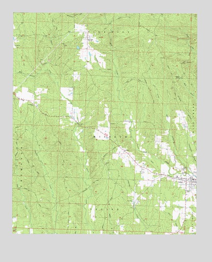
Delight, AR USGS Topographic Map
Click on map above to begin viewing in our Map Viewer.

This topographic map contains these locations and features:
Feature Name Type Latitude Longitude GNIS ID View Map
Brocktown (historical)Populated PlaceN34.0715°W93.6085°64603View Map
Brocktown CemeteryCemeteryN34.0726°W93.6110°46976View Map
City of DelightCivilN34.0299°W93.5058°2404211View Map
DelightPopulated PlaceN34.0315°W93.5030°57637View Map
Delight Ambulance ServiceBuildingN34.0309°W93.5041°2119055View Map
Delight Elementary SchoolSchoolN34.0291°W93.5006°64610View Map
Delight Rural Volunteer Fire DepartmentBuildingN34.0309°W93.5041°2116354View Map
Hopewell (historical)Populated PlaceN34.0637°W93.5435°64618View Map
Little Wolf CreekStreamN34.0334°W93.5021°51343View Map
Mill BranchStreamN34.0926°W93.6018°51978View Map
Pike CityPopulated PlaceN34.1123°W93.5752°53370View Map
Pike City Missionary Baptist ChurchChurchN34.1137°W93.5763°64637View Map
Saline Church of ChristChurchN34.0621°W93.5796°78283View Map
StelltownPopulated PlaceN34.0468°W93.5493°78457View Map
Township of MissouriCivilN34.0538°W93.5502°68964View Map
Wildcat SpringSpringN34.0890°W93.5117°56369View Map

Note: Coordinates in the location and feature list above are referenced to NAD83 datum.


Copyright (C) 2008-2025 Ryan Niemi / Sunset Dynamics ... All Rights Reserved