TopoQuest Logo
Do you find TopoQuest useful?
Help keep TopoQuest running and adding new maps/features by donating!
Bitcoin:  19c7KJd3qBynnjoSw5npx9KScwjBe4ifkT
Litecoin:  LXs6TkuXGGXo1vDsWCkWVdjQX94eUKd6ui
Home View Maps Find Maps Find Places Resources & Links


Nemo, South Dakota Topographic Map

USGS Map Title: Nemo, SD
USGS Map MRC: 44103B5
DRG (GeoTIFF) Download: o44103b5.tif


Neighboring USGS Topographic Map Quads:


  Deadwood South, SD  
44103C6
 

  Deadman Mountain, SD  
44103C5
 

  Tilford, SD  
44103C4
 

  Minnesota Ridge, SD  
44103B6
 

  Nemo, SD  
44103B5
 

  Piedmont, SD  
44103B4
 

  Rochford, SD  
44103A6
 

  Silver City, SD  
44103A5
 

  Pactola Dam, SD  
44103A4


Map MRC Location:

N45°
W104°
N45°
W103°
H8 H7 H6 H5 H4 H3 H2 H1
G8 G7 G6 G5 G4 G3 G2 G1
F8 F7 F6 F5 F4 F3 F2 F1
E8 E7 E6 E5 E4 E3 E2 E1
D8 D7 D6 D5 D4 D3 D2 D1
C8 C7 C6 C5 C4 C3 C2 C1
B8 B7 B6 B5 B4 B3 B2 B1
A8 A7 A6 A5 A4 A3 A2 A1
N44°
W104°
N44°
W103°

Nemo, SD USGS 1:24K Topographic Map Preview:
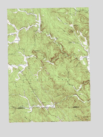
Nemo, SD USGS Topographic Map
Click on map above to begin viewing in our Map Viewer.

This topographic map contains these locations and features:
Feature Name Type Latitude Longitude GNIS ID View Map
BenchmarkPopulated PlaceN44.2253°W103.5782°1261253View Map
Blue DrawValleyN44.1927°W103.5184°1261305View Map
Box Elder Forks CampgroundLocaleN44.1978°W103.5346°1263020View Map
Boxelder CampLocaleN44.2094°W103.5502°1261333View Map
Boxelder Civilian Conservation CenterLocaleN44.2097°W103.5524°1263019View Map
Buck MountainSummitN44.1292°W103.5116°1261356View Map
Channing (historical)Populated PlaceN44.2417°W103.5171°1264570View Map
Corral CreekStreamN44.2250°W103.6091°1261489View Map
Crystal MountainSummitN44.2028°W103.5855°1261517View Map
Gingrass DrawValleyN44.1523°W103.5367°1261717View Map
Green DrawValleyN44.2195°W103.5214°1261741View Map
Green TopSummitN44.2237°W103.5293°1261745View Map
GreenwoodPopulated PlaceN44.2203°W103.5616°1265238View Map
Hay CreekStreamN44.2286°W103.5763°1261791View Map
Hill Side SchoolSchoolN44.1603°W103.5882°1261815View Map
Lucky Strike MineMineN44.2292°W103.5977°1262005View Map
MerrittPopulated PlaceN44.1408°W103.5685°1262057View Map
Middle Boxelder CreekStreamN44.2236°W103.6105°1262066View Map
NemoPopulated PlaceN44.1942°W103.5049°1262118View Map
Nemo CemeteryCemeteryN44.1873°W103.5063°2779181View Map
Nemo Post OfficePost OfficeN44.1927°W103.5037°2710618View Map
Nemo Volunteer Fire DepartmentBuildingN44.1926°W103.5037°2580990View Map
Nemo Work CenterLocaleN44.1930°W103.5046°1263021View Map
North Boxelder CreekStreamN44.2236°W103.6105°1262140View Map
North Fork Estes CreekStreamN44.1692°W103.5349°1262145View Map
NovakPopulated PlaceN44.2164°W103.5519°1265307View Map
Pilot KnobSummitN44.1453°W103.5720°1262204View Map
Richard DrawValleyN44.1918°W103.5138°1262301View Map
Roberts DrawValleyN44.1791°W103.5018°1262310View Map
Silver Arrow TrailTrailN44.1292°W103.5494°1263036View Map
Slabtown (historical)LocaleN44.2139°W103.5552°1264538View Map
South Boxelder CreekStreamN44.1967°W103.5341°1262452View Map
South Boxelder Summer Home GroupLocaleN44.1964°W103.5382°1263022View Map
String Town Logging Camp (historical)LocaleN44.1486°W103.5241°1264536View Map
TomahawkPopulated PlaceN44.2119°W103.5285°1262601View Map
West Fork Estes CreekStreamN44.1650°W103.5313°1258896View Map
White MansionSummitN44.2294°W103.5202°1262698View Map
Wilson DrawValleyN44.2289°W103.5262°1262728View Map

Note: Coordinates in the location and feature list above are referenced to NAD83 datum.


Copyright (C) 2008-2024 Ryan Niemi / Sunset Dynamics ... All Rights Reserved