TopoQuest Logo
Do you find TopoQuest useful?
Help keep TopoQuest running and adding new maps/features by donating!
Bitcoin:  19c7KJd3qBynnjoSw5npx9KScwjBe4ifkT
Litecoin:  LXs6TkuXGGXo1vDsWCkWVdjQX94eUKd6ui
Home View Maps Find Maps Find Places Resources & Links


Neoga, Illinois Topographic Map

USGS Map Title: Neoga, IL
USGS Map MRC: 39088C4
DRG (GeoTIFF) Download: o39088c4.tif


Neighboring USGS Topographic Map Quads:


  Windsor, IL  
39088D5
 

  Mattoon West, IL  
39088D4
 

  Mattoon East, IL  
39088D3
 

  Stewardson East, IL  
39088C5
 

  Neoga, IL  
39088C4
 

  Johnstown, IL  
39088C3
 

  Effingham North, IL  
39088B5
 

  Teutopolis, IL  
39088B4
 

  Woodbury, IL  
39088B3


Map MRC Location:

N40°
W89°
N40°
W88°
H8 H7 H6 H5 H4 H3 H2 H1
G8 G7 G6 G5 G4 G3 G2 G1
F8 F7 F6 F5 F4 F3 F2 F1
E8 E7 E6 E5 E4 E3 E2 E1
D8 D7 D6 D5 D4 D3 D2 D1
C8 C7 C6 C5 C4 C3 C2 C1
B8 B7 B6 B5 B4 B3 B2 B1
A8 A7 A6 A5 A4 A3 A2 A1
N39°
W89°
N39°
W88°

Neoga, IL USGS 1:24K Topographic Map Preview:
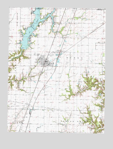
Neoga, IL USGS Topographic Map
Click on map above to begin viewing in our Map Viewer.

This topographic map contains these locations and features:
Feature Name Type Latitude Longitude GNIS ID View Map
Apperson School (historical)SchoolN39.3603°W88.4120°403575View Map
Beehive School (historical)SchoolN39.3281°W88.3787°404104View Map
Brush CreekStreamN39.3681°W88.4473°405029View Map
Brush Creek CemeteryCemeteryN39.2506°W88.3878°1820722View Map
Brush Creek ChurchChurchN39.2511°W88.3889°405038View Map
Bush CreekStreamN39.3631°W88.4592°405283View Map
Bush CreekStreamN39.3503°W88.4345°1964788View Map
Carrey School (historical)SchoolN39.2736°W88.4903°405633View Map
City of NeogaCivilN39.3219°W88.4500°2395170View Map
Clear CreekStreamN39.3728°W88.4631°406206View Map
Concord CemeteryCemeteryN39.3575°W88.4703°1820723View Map
Concord Church (historical)ChurchN39.3578°W88.4700°406446View Map
Copperas CemeteryCemeteryN39.2995°W88.4898°1821159View Map
Copperas School (historical)SchoolN39.2986°W88.4898°406577View Map
Crossing School (historical)SchoolN39.3453°W88.4434°406833View Map
Downey CemeteryCemeteryN39.2995°W88.4995°1821161View Map
First Christian Church of NeogaChurchN39.3192°W88.4512°1967355View Map
Grace United Methodist ChurchChurchN39.3211°W88.4539°1967356View Map
Illinois Central Pioneer CemeteryCemeteryN39.2510°W88.3874°1922836View Map
Illinois Central Railroad CemeteryCemeteryN39.3514°W88.4362°1923023View Map
Interchange 177CrossingN39.3323°W88.4334°1773393View Map
Lake MattoonReservoirN39.3561°W88.4694°1691086View Map
Lake Mattoon DamDamN39.3342°W88.4828°1691085View Map
Lambert School (historical)SchoolN39.3609°W88.3787°411777View Map
Lockhart CemeteryCemeteryN39.3573°W88.4706°1922840View Map
Lone Elm School (historical)SchoolN39.2592°W88.4534°412532View Map
Long Point CemeteryCemeteryN39.2953°W88.4095°1820734View Map
Long Point School (historical)SchoolN39.3009°W88.4073°412593View Map
Maple Grove School (historical)SchoolN39.3300°W88.4059°412931View Map
NeogaPopulated PlaceN39.3195°W88.4528°414363View Map
Neoga CemeteryCemeteryN39.3103°W88.4584°414364View Map
Neoga Elementary SchoolSchoolN39.3203°W88.4598°1773397View Map
Neoga Fire Protection DistrictBuildingN39.3215°W88.4527°2681745View Map
Neoga Police DepartmentBuildingN39.3188°W88.4538°2759041View Map
Neoga Post OfficePost OfficeN39.3189°W88.4502°1773398View Map
Neoga Railroad Crossing CemeteryCemeteryN39.3456°W88.4450°1820724View Map
Neoga Senior High SchoolSchoolN39.3195°W88.4420°1773399View Map
Prairie School (historical)SchoolN39.3598°W88.4898°416158View Map
Raney CemeteryCemeteryN39.2995°W88.4900°1928150View Map
Township of NeogaCivilN39.3234°W88.3970°429425View Map
Walk School (historical)SchoolN39.2867°W88.4523°420394View Map
Wateroak School (historical)SchoolN39.3314°W88.4895°420635View Map
West Union School (historical)SchoolN39.2725°W88.4150°420936View Map
Whitehall Church (historical)ChurchN39.2786°W88.3875°421089View Map
Whitehall School (historical)SchoolN39.2720°W88.3781°421090View Map
Williamson AirportAirportN39.3185°W88.4252°427597View Map
Zion CemeteryCemeteryN39.3595°W88.4439°1820745View Map
Zion Chapel United Brethren Church (historical)ChurchN39.3600°W88.4450°1820746View Map
Zion School (historical)SchoolN39.3600°W88.4481°421670View Map

Note: Coordinates in the location and feature list above are referenced to NAD83 datum.


Copyright (C) 2008-2024 Ryan Niemi / Sunset Dynamics ... All Rights Reserved